
Elevation 4,528 m | Length 3,500 km (2,200 mi) | |
 | ||
Mountains Mount Kirkpatrick, Mount Markham, Mount Hope Similar Beard Glacier, Antarctic ice sheet, Mount Erebus, Byrd Glacier, Lake Vostok | ||
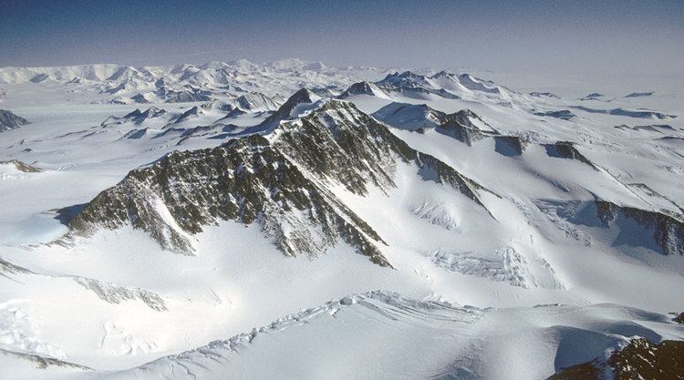
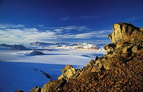
Flying over antarctica the transantarctic mountains
The Transantarctic Mountains (abbreviated TAM) comprise a mountain range of uplifted sedimentary rock in Antarctica which extend, with some interruptions, across the continent from Cape Adare in northern Victoria Land to Coats Land. These mountains divide East Antarctica and West Antarctica. They include a number of separately named mountain groups, which are often again subdivided into smaller ranges.
Contents
- Flying over antarctica the transantarctic mountains
- Transantarctic mountains on the way to the south pole
- Geography
- Biology
- History
- Geology
- References
The range was first sighted by James Clark Ross in 1841 at what was later named the Ross Ice Shelf in his honor. It was first crossed during the British National Antarctic Expedition of 1901-1904.
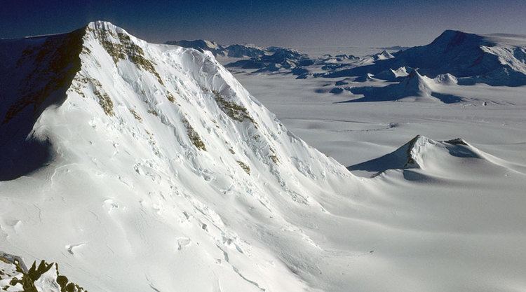
Transantarctic mountains on the way to the south pole
Geography
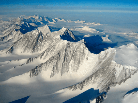
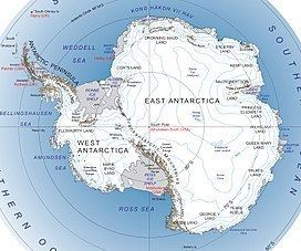
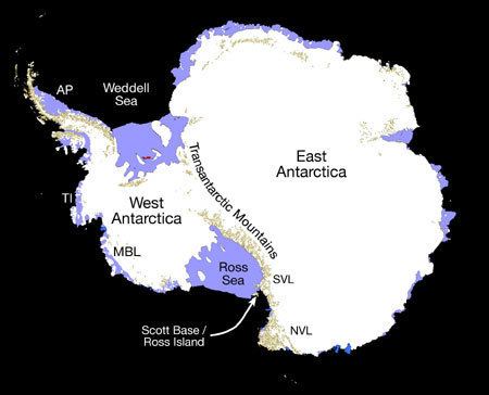
The mountain range stretches between the Ross Sea and the Weddell Sea the entire length of Antarctica, hence the name. With a total length of about 3,500 km, the Transantarctic Mountains are one of the longest mountain ranges on Earth. The 100–300 km wide range forms the boundary between East Antarctica and West Antarctica. The East Antarctic Ice Sheet bounds the TAM along their entire length on the Eastern Hemisphere side, while the Western Hemisphere side of the range is bounded by the Ross Sea (C.Michael Hogan. 2011) in Victoria Land from Cape Adare to McMurdo Sound, the Ross Ice Shelf from McMurdo Sound to near the Scott Glacier, and the West Antarctic Ice Sheet beyond.
The summits and dry valleys of the TAM are some of the few places in Antarctica not covered by ice, the highest of which rise more than 4,500 metres (14,800 ft) above sea level. The McMurdo Dry Valleys lie near McMurdo Sound and represent a special Antarctic phenomenon: landscapes that are snow and ice free due to the extremely limited precipitation and ablation of ice in the valleys. The highest mountain of the TAM is 4,528 m high Mount Kirkpatrick in the Queen Alexandra Range. Isolated peaks surrounded by ice are referred to as nunataks.
Biology
Penguins, seals, and sea birds live along the Ross Sea coastline in Victoria Land, while life in the interior of the Transantarctic Range is limited to bacteria, lichens, algae, and fungi. Forests once covered Antarctica, including plentiful Wollemi Pine and Southern Beech. However, with the gradual cooling associated with the break-up of Gondwana, these forests gradually disappeared. It is believed that the last trees on the Antarctic continent were on Transantarctic Mountains.
History
The Transantarctic Mountains were first seen by Captain James Ross in 1841 from the Ross Sea. The range is a natural barrier that must be crossed to reach the South Pole from the Ross Ice Shelf.
The first crossing of the Transantarctic Mountains took place during the 1902-1904 British National Antarctic Expedition at the Ross Ice Shelf. A reconnaissance party under the command of Albert Armitage reached 2700 m altitude in 1902. The following year a party under expedition leader Robert Falcon Scott crossed into East Antarctica at a location now known as Ferrar Glacier, named after the geologist of the expedition. They explored part of Victoria Land on the Antarctic Plateau before returning via the same glacier. In 1908, Ernest Shackleton's party crossed the mountains through the Beardmore Glacier. Robert Scott returned to that same glacier in 1911, while Roald Amundsen crossed the range via the Axel Heiberg Glacier.
Much of the range remained unexplored until the late 1940s and 1950s, when missions such as Operation Highjump and the International Geophysical Year (IGY) made extensive use of aerial photography and concentrated on a thorough investigation of the entire continent. The name "Transantarctic Mountains" was first applied to this range in a 1960 paper by geologist Warren B. Hamilton, following his IGY fieldwork. It was subsequently recommended by the US-ACAN committee, a US authority for geographic names, in 1962. This purely descriptive label (in contrast to many other geographic names on Antarctica) is internationally accepted at present.
The Leverett Glacier in the Queen Maud Mountains is the planned route through the TAM for the overland supply road between McMurdo Station and Amundsen–Scott South Pole Station.
Geology
The Transantarctic Mountains are considerably older than other mountain ranges of the continent that are mainly volcanic in origin. The range was uplifted during the opening of the West Antarctic Rift to the east, beginning about 65 million years ago in the early Cenozoic.
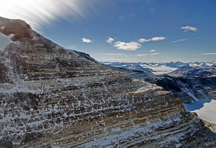
The mountains consist of sedimentary layers lying upon a basement of granites and gneisses. The sedimentary layers include the Beacon Supergroup sandstones, siltstones, and coal deposited beginning in the Silurian period and continuing into the Jurassic. In many places the Beacon Supergroup has been intruded by dikes and sills of Jurassic age Ferrar Dolerite. Many of the fossils found in Antarctica are from locations within these sedimentary formations.
Ice from the East Antarctic ice sheet flows through the Transantarctic Mountains via a series of outlet glaciers into the Ross Sea, Ross Ice Shelf, and West Antarctic Ice Sheet. These glaciers generally flow perpendicular to the orientation of the range and define subranges and peak groups. It is thought that many of these outlet glaciers follow the traces of large-scale geologic faults.