
Elevation 3,478 m | Last eruption 8350 BCE ± 1000 years Mountain range Flood Range | |
 | ||
Similar | ||
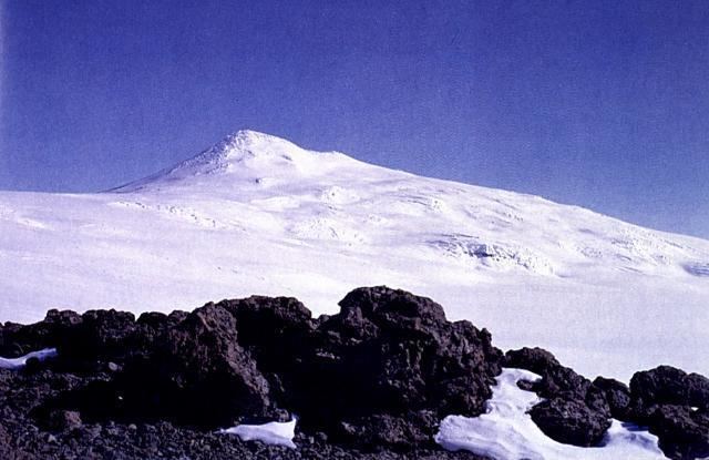
Mount Berlin is the sixth highest volcano in Antarctica, located 16 km west of Mount Moulton in Marie Byrd Land near the eastern coast of the Ross Sea. It is composed of two coalesced shield volcanoes: Merrem Peak (3,000 m) and Berlin Crater (3,478 m). The volcanic structure is considered active, as steaming fumaroles have been observed near the rim of the northern and western calderas, producing fumarolic ice towers.
Contents
- Map of Mount Berlin Antarctica
- Etymology
- Geomorphology and geography
- Petrology
- Eruptive history
- References
Map of Mount Berlin, Antarctica
Etymology
Mount Berlin was named by the Advisory Committee on Antarctic Names for Leonard M. Berlin, leader of the United States Antarctic Program party which sledged to this mountain in December 1940.
Geomorphology and geography
Mount Berlin is 3,478 metres (11,411 ft) high and lies in Marie Byrd Land. It is the highest volcano in the Flood Range and the most impressive as well. Mount Moulton lies 30 kilometres (19 mi) farther east, it is a 40 kilometres (25 mi) long volcanic mountain range with ages of 5.3 million years ago. Mount Berlin lies 100 kilometres (62 mi) away from the coast. The volcano protrudes from the West Antarctic Ice Cap and is itself covered with ice in its summit area.
Mount Berlin belongs to a group of large volcanoes in West Antarctica, together with Mount Takahe. A number of other volcanoes may exist there as well but do not extend above the ice sheets.
Mount Berlin is a large stratovolcano. It has a summit crater 2 kilometres (1.2 mi) wide, with pyroclastic materials exposed in its rims. A subsidiary crater is known as Merrem Crater, which is 2.5 by 1 kilometre (1.55 mi × 0.62 mi) wide and lies 3.5 kilometres (2.2 mi) west of the main summit. These two volcanoes coalesce together to form the Berlin volcano. Mafic volcanic rocks on the north flank may indicate that monogenetic cinder cones formed. An ignimbrite has been identified on the southeastern flank, a type of volcanic activity which is uncommon for Marie Byrd Land volcanoes. Older volcanics are exposed at Brandenburger Bluff, dates range around 2,738,000 ± 63,000 years ago. Brandenburger Bluff lies northwest of the main summit. Unlike the rest of Mount Berlin, which is formed by flow rocks, Brandenburger Bluff is formed by layered hyaloclastite tuffs. One interpretation is that Mount Berlin is formed by two trachytic volcanoes on top of a hydroclastic base. Incipient glacial cirques have been identified.
Petrology
Mount Berlin has erupted trachytes. These have a noticeable peralkaline composition. Additional rocks that were erupted from Berlin are basanite, hawaiite and mugearite.
Phonolithic and phonotephritic rocks are found at Brandenburger Bluff. Over time, the contents of iron in the rocks erupted by Mount Berlin increased and that of silica and potassium. This might indicate that eruptions of Mount Berlin were fed by a large magma chamber, but the more likely explanation is that different eruptions tapped different "batches" of magma which were progressively less evolved.
In the Mount Moulton tephra layers, Berlin rocks assume the form of obsidian and pumice. The pumice fragments can reach sizes of about 3 centimetres (1.2 in).
Eruptive history
Tephrochronology has been used to reconstruct the history of volcanic activity in Antarctica. Tephra from Mount Berlin has been identified in ice cores of the West Antarctic Ice Sheet, in the Mount Moulton ice cap and Vostok ice core. Other rocks on Berlin have been dated directly. The oldest exposed ice in West Antarctica has been determined through tephrochronology data stemming from Mount Berlin tephra as being older than 492,000 years.
Volcanic activity commenced in the Pliocene. The oldest volcanic activity occurred 2.74 ± 0.06 million years ago at Brandenburger Bluff and involved subglacial and subaerial phreatomagmatic activity. Benmoreitic volcanism was active also at Wedemeyer Rocks south of the Berlin main edifice 2.58 ± 0.2 million years ago. Later, trachytic volcanism occurred at Mefford Knoll west of the main edifice 630,000 ± 30,000 and southwest at Kraut Rocks 620,000 ± 50,000 years ago. Volcanic activity then shifted to Merrem Peak, starting 571,000 ± 8,900 years ago. Activity on Merrem Peak was accompanied by flank eruptions forming ignimbrites. Activity finally shifted to Mount Berlin proper, raising the summit of the volcano. Mount Berlin had a phase of increased volcanic activity between 24,000 and 28,000 years ago, according to tephra data. Some eruptions at Berlin were large scale Plinian eruptions, forming eruption columns exceeding heights of 28 kilometres (17 mi) and depositing volcanic ash over large areas.
Individual volcanic eruptions at Berlin occurred 135,600 ± 900 years ago, 118,100 ± 1,300 years ago, 92,100 ± 900 years ago, which was the origin of the so-called marine "Tephra A", 14,500 ± 3,800 and 10,300 ± 5,300 years ago. Two pyroclastic deposits in the Berlin crater wall are dated 25,500 ± 2,000 and 18,200 ± 5,800 years ago. Over time, volcanic activity migrated south-southwestward. Berlin further had volcanic activity in the Holocene, including a lava flow beneath an ice tower that is dated 10,300 ± 2,700 years ago. A tephra dated 7,756 BC is similar to a lava flow from Mount Berlin in terms of composition and may originate from an eruption there. Another similar tephra is dated 9,346 BCE.
LeMasurier in 1990 identified the volcano as "potentially active". Fumarolic activity has formed ice towers that emit steam, making it the only volcano in Marie Byrd Land with ongoing geothermal activity. One ice cave associated with an ice tower had rock temperatures measured at 12 °C (54 °F). These fumarolic phenomena all occur along the northern and western rims of the Berlin Crater. Volcano-tectonic earthquakes have been identified at Mount Berlin. They occur at depths of 15–20 kilometres (9.3–12.4 mi).