
 | ||
Islands Beaufort Island, Franklin Island | ||
The ross sea antarctic marine park behind the news
The Ross Sea is a deep bay of the Southern Ocean in Antarctica, between Victoria Land and Marie Byrd Land. It derives its name from the British explorer James Ross who visited this area in 1841. To the west of the sea lies Ross Island and to the east Roosevelt Island, while the southernmost part is covered by the Ross Ice Shelf, and is about 200 miles (320 km) from the South Pole.
Contents
- The ross sea antarctic marine park behind the news
- Map of Ross Sea
- Spectacular ross sea
- Description
- The Ross System
- Circulation
- Ecological importance and conservation
- Biodiversity
- Toothfish Fishery
- Marine Protected Area
- References
Map of Ross Sea
The underlying rocks are of upper Precambrian to lower Paleozoic age and are partly composed of calcium carbonate. The circulation of the Ross Sea is dominated by a wind-driven ocean gyre and the flow is strongly influenced by three submarine ridges that run from southwest to northeast. The circumpolar deep water current is a relatively warm, salty and nutrient-rich water mass that flows onto the continental shelf at certain locations. The Ross Sea is covered with ice for most of the year.
The nutrient-laden water supports an abundance of plankton and this encourages a rich marine fauna. At least ten mammal species, six bird species and 95 fish species are found here, as well as many invertebrates, and the sea remains relatively unaffected by human activities. New Zealand has claimed that the sea comes under their jurisdiction as part of the Ross Dependency, but this is disputed by other nations. Marine biologists consider the sea to have a high level of biological diversity and it is the site of much scientific research. It is also the focus of some environmentalist groups who have campaigned to have the area proclaimed as a world marine reserve.
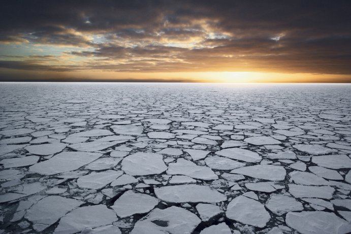
Spectacular ross sea
Description
The Ross Sea was discovered by James Ross in 1841. In the west of the Ross Sea is Ross Island with the Mt. Erebus volcano, in the east Roosevelt Island. The southern part is covered by the Ross Ice Shelf. Roald Amundsen started his South Pole expedition in 1911 from the Bay of Whales, which was located at the shelf. In the west of the Ross sea, McMurdo Sound is a port which is usually free of ice during the summer. The southernmost part of the Ross Sea is Gould Coast, which is approximately two hundred miles from the Geographic South Pole.
All land masses in the Ross Sea are claimed by New Zealand to fall under the jurisdiction of the Ross Dependency, but few non-Commonwealth nations recognise this claim.
A 10-metre (32.8 feet) long colossal squid weighing 495 kilograms (1,091 lb) was captured in the Ross Sea on February 22, 2007.
The Ross System
Ross System rocks are of upper Precambrian to lower Paleozoic age and each group of Ross System have an echelon vein pattern demonstrating possible dextral faulting. These miogeosyncline metasedimentary rocks are usually folded about northwest and southeast axes and are partly composed of calcium carbonate, often including limestone. Groups within the Ross System include the Robertson Bay Group, Priestley Group, Skelton Group, Beardmore Group, Byrd Group, Queen Maud Group, and Koettlitz Group. The Robertson Bay Group ranges from 56 to 76% silica and compares closely with other Ross System members. The Priestley Group rocks are similar to those of the Robertson Bay Group and include dark slates, argillites, siltstones, fine sandstones and limestones. They can be found near the Priestley and Campbell glaciers. For thirty miles along the lower Skelton Glacier are the calcareous greywackes and argillites of the Skelton Group. The region between the lower Beardmore Glacier and the lower Shackelton Glacier sits the Beardmore Group. North of the Nimrod Glacier are four block faulted ranges that make up the Byrd Group. The contents of the Queen Maud Group area are mainly post-tectonic granite.
Circulation
The Ross Sea circulation, dominated by polynya processes, is in general very slow-moving. Circumpolar Deep Water (CDW) is a relatively warm, salty and nutrient-rich water mass that flows onto the continental shelf at certain locations in the Ross Sea. Through heat flux, this water mass moderates the ice cover. The near-surface water also provides a warm environment for some animals and nutrients to excite primary production. CDW transport onto the shelf is known to be persistent and periodic, and is thought to occur at specific locations influenced by bottom topography. The circulation of the Ross Sea is dominated by a wind-driven gyre. The flow is strongly influenced by three submarine ridges that run from southwest to northeast. Flow over the shelf below the surface layer consists of two anticyclonic gyres connected by a central cyclonic flow. The flow is considerable in spring and winter, due to influencing tides. The Ross Sea is covered with ice for much of the year and ice concentrations and in the south-central region little melting occurs. Ice concentrations in the Ross Sea are influenced by winds with ice remaining in the western region throughout the austral spring and generally melting in January due to local heating. This leads to extremely strong stratification and shallow mixed layers in the western Ross Sea.
Ecological importance and conservation
The Ross Sea is one of the last stretches of seas on Earth that remains relatively unaffected by human activities. Because of this, it remains almost totally free from pollution and the introduction of invasive species. Consequently, the Ross Sea has become a focus of numerous environmentalist groups who have campaigned to make the area a world marine reserve, citing the rare opportunity to protect the Ross Sea from a growing number of threats and destruction. The Ross Sea is regarded by marine biologists as having a very high biological diversity and as such has a long history of human exploration and scientific research, with some datasets going back over 150 years.
Biodiversity
The Ross Sea is home to at least 10 mammal species, half a dozen species of birds, 95 species of fish, and over 1,000 invertebrate species. Some species of birds that nest in and near the Ross Sea include the Adélie penguin, emperor penguin, Antarctic petrel, snow petrel, and south polar skua. Marine mammals in the Ross Sea include the Antarctic minke whale, killer whale, Weddell seal, crabeater seal, and leopard seal. Antarctic toothfish, Antarctic silverfish, Antarctic krill, and crystal krill also swim in the cold Antarctic water of the Ross Sea.
The flora and fauna are considered similar to other southern Antarctic marine regions. Particularly in Summer, the nutrient-rich sea water supports an abundant planktonic life in turn providing food for larger species, such as fish, seals, whales, and sea- and shore-birds.
Albatrosses rely on wind to travel and cannot get airborne in a calm. The westerlies do not extend as far south as the ice edge and therefore albatrosses do not travel often to the ice-pack. An albatross would be trapped on an ice floe for many days if it landed in the calm.
The coastal parts of the sea contain a number of rookeries of Adélie and Emperor penguins, which have been observed at a number of places around the Ross Sea, both towards the coast and outwards in open sea.
Toothfish Fishery
In 2010, the Ross Sea Antarctic toothfish fishery was independently certified by the Marine Stewardship Council, and has been rated as a 'Good Alternative' by the Monterey Bay Aquarium Seafood Watch program. However, a 2008 document submitted to the CCAMLR reported significant declines in toothfish populations of McMurdo Sound coinciding with the development of the industrial toothfishing industry since 1996, and other reports have noted a coincident decrease in the number of orcas. The report recommended a full moratorium on fishing over the Ross shelf. In October 2012, Philippa Ross, James Ross' great, great, great granddaughter, voiced her opposition to fishing in the area.
Marine Protected Area
Beginning in 2005, the Commission for the Conservation of Antarctic Marine Living Resources (CCAMLR) commissioned scientific analysis and planning for Marine Protected Areas (MPA) in the Antarctic. In 2010, the CCAMLR endorsed their Scientific Committee’s proposal to develop Antarctic MPAs for conservation purposes. The US State Department submitted a proposal for a Ross Sea MPA at the September 2012 meeting of the CCAMLR.
In July 2013, the CCAMLR held a meeting in Bremerhaven in Germany, to decide whether to turn the Ross Sea into an MPA. The deal failed due to Russia voting against it, citing uncertainty about whether the commission had the authority to establish a marine protected area.
In October 2014, the MPA proposal was again defeated at the CCAMLR by votes against from China and Russia. At the October 2015 meeting a revised MPA proposal from the US and New Zealand was expanded with the assistance of China, who however shifted the MPA's priorities from conservation by allowing commercial fishing. The proposal was again blocked by Russia.
On 28 October 2016, at its annual meeting in Hobart, a Ross Sea marine park was finally declared by the CCAMLR, under an agreement signed by 24 countries and the European Union. It protects over 1.5 million square kilometres of sea, and is the world's largest. However, a sunset provision of 35 years was inserted as part of negotiations, which means it does not meet the International Union for Conservation of Nature definition of a marine protected area, which requires it to be permanent.