
Length 301.9 km | ||
 | ||
East end: Western Divide Highway at Quaking Aspen | ||
California state route 190 time lapse
State Route 190 (SR 190) is a state highway in the U.S. state of California that is split into two parts by the Sierra Nevada. The western portion of begins at Tipton at a junction with State Route 99 and heads east towards Porterville before ending at Quaking Aspen in the Sequoia National Forest. The eastern portion begins at US 395 at Olancha, heads east through Death Valley National Park, and ends at State Route 127 at Death Valley Junction. The 43.0-mile (69.2 km) portion over the Sierra Nevada remains unconstructed, and the California Department of Transportation (Caltrans) has no plans to build it through the wilderness areas.
Contents
- California state route 190 time lapse
- Map of CA 190 California USA
- Route description
- History
- Major intersections
- References
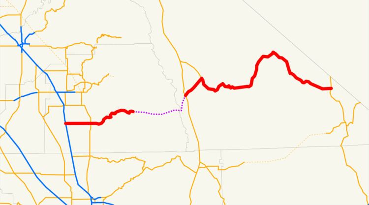
Map of CA-190, California, USA
The route east of State Route 136 near Keeler is on the California Freeway and Expressway System, but is a two-lane road. Except west of State Route 65 in Porterville, SR 190 is eligible for the State Scenic Highway System; the part within Death Valley National Park, known as the Death Valley Scenic Byway, has been added to the system and is a National Scenic Byway.
Route description
State Route 190 begins at State Route 99 just south of downtown Tipton in Tulare County and heads straight east along the flat San Joaquin Valley on Avenue 144. There is a short expressway segment in Porterville, including a cloverleaf interchange at State Route 65 and a partial interchange at Main Street, after which the highway begins to curve alongside the Tule River, passing the south side of Lake Success, as the terrain becomes more rugged. Following the river, it meets the south end of County Route J37, an access road to Balch Park in the Mountain Home State Forest, at the forks of the river near the community of Springville. SR 190 continues east near the Middle Fork and South Fork Middle Fork Tule River to near Camp Nelson, where it begins rising into the foothills, going around many hairpin curves in order to rise to Quaking Aspen, the source of the South Fork Middle Fork and the end of the western segment of SR 190. The county-maintained Western Divide Highway continues south to a point west of Johnsondale, where traffic can turn east to reach US 395 via Sherman Pass and County Route J41.
From Quaking Aspen across the Sierra Nevada to Olancha, Caltrans has adopted a proposed alignment, but is unlikely to build it, in part due to two protected wilderness areas—the Golden Trout Wilderness and South Sierra Wilderness—along the route. The unconstructed routing heads northeast from Quaking Aspen, cresting a small summit before following Freeman Creek easterly past the Freeman Creek Grove, crossing the Kern River near its forks, and then using the path of Rattlesnake Creek and Beach Creek to the Beach Meadows area. Crossing several ridges to the northeast, SR 190 would make its way to the South Fork Kern River near Monache Mountain, then heading southeast along that waterway to the vicinity of Haiwee Pass. That pass, elevation about 8200 feet (2500 m) above sea level, would take the highway over the Sierra crest into Inyo County, dropping for 12.0 miles (19.3 km) in a north-northeasterly direction to US 395 at Olancha (elevation 3650 feet/1100 m).
The eastern section of SR 190 begins at Olancha in the Owens Valley, at the intersection with US 395. The route heads northeast along the southeast side of Owens Lake to the junction with SR 136 southeast of Keeler, where it turns southeast and east around the south side of the Inyo Mountains. After passing the turnoff to Darwin, SR 190 enters Death Valley National Park and becomes curvier as it heads down into the Panamint Valley. The highway crosses the valley and then turns northeast over Towne Pass and into the northern part of Death Valley at Stovepipe Wells. Within the valley, at the intersection with North Highway, which leads to Scotty's Castle and Beatty, Nevada, SR 190 turns southeast through Death Valley, which it remains inside until the turnoff to Badwater Basin, the lowest point in North America, near the settlement of Furnace Creek. It leaves the valley to the southeast alongside Furnace Creek Wash, where the highway is usually closed at least once a year by flash floods. SR 190 turns east away from the wash at the turnoff to Dante's View, and soon leaves the park, after which it follows a mostly straight alignment to its end at State Route 127 at Death Valley Junction.
History
The path of SR 190 east of the Panamint Range in Death Valley National Park was followed in late 1849 and early 1850 by the Death Valley '49ers, a group of '49ers that had left the Old Spanish Trail at Enterprise, Utah to look for a shortcut to Walker Pass. The pioneers crossed the state line from Nevada near Ash Meadows, following the general route of present SR 190 from Death Valley Junction into Death Valley, which they left to the west into Panamint Valley and then turned south towards present State Route 178. After ore was discovered in Death Valley, the route became a primitive road, though most travel into the valley, such as the twenty mule team borax route, was from the south.
The second boom in Death Valley was tourism, started in the 1920s by Herman Eichbaum. After several failures in getting a toll road approved from Lida, Nevada or over Towne Pass, he scaled back plans to include only the part of the latter route between southeast of Darwin and his resort at Stovepipe Wells. The new Eichbaum Toll Road was certified complete on May 4, 1926, and toll rates were set: $2 per motor vehicle and 50¢ per person. In 1933, the state legislature added many roads to the state highway system, including a new (unsigned) Route 127, connecting Tipton with Baker via Lone Pine and Death Valley Junction. The Death Valley National Monument was created on February 11, 1933, and in December 1934 the Division of Highways paid $25,000 for the 30.35-mile (48.84 km) road, giving the 17 miles (27 km) east of the park boundary at the pass to the National Park Service. The state Division of Highways and National Park Service soon paved the route from Lone Pine (on US 395) through Towne Pass and Death Valley to Baker (on US 91). The work was completed in October 1937, including the 17.5-mile (18 km) Darwin cutoff that bypassed Darwin and the old toll road west of Panamint Springs. The National Park Service, using Civilian Conservation Corps labor, maintained the road through the park until August 1942, when an 11-mile (18 km) stretch east of the valley was washed out by a storm. At that time, maintenance was given back to the state, which rebuilt the destroyed segment.
When the state sign route system was created in 1934, Sign Route 190 was assigned to the portion of Route 127 west of Death Valley Junction, while the remainder to Baker became part of Sign Route 127. However, the highway was not continuous, with the roadway from Tipton (which had been built by Tulare County) ending at Quaking Aspen (east of Camp Nelson) and that from Death Valley ending southwest of Lone Pine. In 1923, Tulare County businessmen had begun to push for a new trans-Sierra highway connecting Porterville with Lone Pine, but were set back by a lack of state aid, as the road was not a state highway. The first piece, which would turn out to be the only one built, opened in early July 1931 to Quaking Aspen (and became a state highway in 1933). Grading of the 15-mile (24 km) Western Divide Highway, a county road that was supposed to continue south to State Route 155 at Greenhorn Summit, was completed from Quaking Aspen south to near Johnsondale in July 1962. A new road from Johnsondale across Sherman Pass, maintained by the U.S. Forest Service and Tulare and Inyo Counties (the latter as County Route J41), was completed in 1976, allowing traffic on the western segment of SR 190 to reach US 395, though via a longer route than the proposed SR 190.
In March 1959, Tulare County approved a change in location of the proposed highway to Olancha Pass (Haiwee Pass, just to the south, was soon considered for a possible alternate location), and the legislature moved the main line of Route 127 south to that location, crossing US 395 at Olancha, later that year. The old route from southeast of Keeler to Lone Pine remained as a branch, and was still signed as SR 190. Also in 1959, the original routing from Lone Pine through Death Valley to Baker was added to the proposed California Freeway and Expressway System, though no parts have been upgraded as such. The east–west piece between Tipton and Death Valley Junction legislatively received the State Route 190 designation in the 1964 renumbering, and the north–south part became State Route 127, which it had been signed as; the branch to Lone Pine became a new State Route 136. By the mid-1970s, the environmental movement had essentially killed the planned connection, and the designation of the Golden Trout Wilderness in 1978 and South Sierra Wilderness in 1984 were the final blow, though Caltrans still has an officially adopted alignment designated over Haiwee Pass.
Major intersections
Except where prefixed with a letter, postmiles were measured on the road as it was in 1964, based on the alignment that existed at the time, and do not necessarily reflect current mileage. R reflects a realignment in the route since then, M indicates a second realignment, L refers an overlap due to a correction or change, and T indicates postmiles classified as temporary (for a full list of prefixes, see the list of postmile definitions). Segments that remain unconstructed or have been relinquished to local control may be omitted. The numbers reset at county lines; the start and end postmiles in each county are given in the county column.