
ZIP codes 92309 Elevation 287 m Population 735 (1 Apr 2010) Local time Tuesday 9:56 AM | State California Area codes 442/760 Area 6.962 km² Zip code 92309 Number of airports 1 | |
 | ||
Weather 12°C, Wind E at 5 km/h, 44% Humidity | ||
Baker california
Baker is a census-designated place located in San Bernardino County, California, USA. As of the 2010 census, the town had a total population of 735. Baker's ZIP Code is 92309 and the community is within area codes 442 and 760.
Contents
- Baker california
- Map of Baker CA USA
- History
- Geography and climate
- Demographics
- Economy
- State and federal representation
- Appearances in films and television
- Mars rover test site
- Attractions
- Transportation
- References
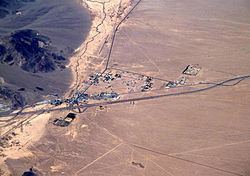
Map of Baker, CA, USA
History
Baker was founded as a station on the Tonopah and Tidewater Railroad in 1908, and was named after Richard C. Baker, business partner of Francis Marion Smith in building the railroad. Baker later became president of the T&T himself.
Baker was established in 1929 by Ralph Jacobus Fairbanks (1857–1942), who was an American prospector, entrepreneur and pioneer who established several towns in the Death Valley area of California, including Fairbanks Springs (1904–05) and Shoshone (1910).
It is the site of a vacant for-profit prison formerly operated by Cornell Corrections which experienced a major riot on December 2, 2003, four weeks before it was temporarily closed. It was permanently closed on December 25, 2009. GEO Group purchased Cornell Companies, its owner, on August 12, 2010. It had previously experienced escapes in August and November 1995, and two on July 15, 1997.
Geography and climate
Baker is located at (35.265099, -116.074768). Baker is located in the Mojave Desert at the junction of Interstate 15 and SR 127 (Death Valley Road). Its elevation is approximately 930 feet (283.5 m) above sea level, which is much lower than either Barstow or Las Vegas, due to its location at the southern end of the Death Valley geological depression. The Cronese Mountains are located southwest of the community. According to the United States Census Bureau, the CDP covers an area of 2.7 square miles (7.0 km²), all of it land. Summer temperatures in Baker routinely exceed 110 °F (43.3 °C); 2007 saw a record of 125 °F (51.7 °C).
Demographics
The 2010 United States Census reported that Baker had a population of 735. The population density was 273.5 people per square mile (105.6/km²). The racial makeup of Baker was 302 (41.1%) White (26.5% Non-Hispanic White), 1 (0.1%) African American, 5 (0.7%) Native American, 10 (1.4%) Asian, 14 (1.9%) Pacific Islander, 380 (51.7%) from other races, and 23 (3.1%) from two or more races. Hispanic or Latino of any race were 502 persons (68.3%).
The Census reported that 731 people (99.5% of the population) lived in households, 4 (0.5%) lived in non-institutionalized group quarters, and 0 (0%) were institutionalized.
There were 215 households, out of which 122 (56.7%) had children under the age of 18 living in them, 106 (49.3%) were opposite-sex married couples living together, 39 (18.1%) had a female householder with no husband present, 23 (10.7%) had a male householder with no wife present. There were 29 (13.5%) unmarried opposite-sex partnerships, and 1 (0.5%) same-sex married couples or partnerships. 28 households (13.0%) were made up of individuals and 4 (1.9%) had someone living alone who was 65 years of age or older. The average household size was 3.40. There were 168 families (78.1% of all households); the average family size was 3.74.
The population was spread out with 277 people (37.7%) under the age of 18, 80 people (10.9%) aged 18 to 24, 236 people (32.1%) aged 25 to 44, 121 people (16.5%) aged 45 to 64, and 21 people (2.9%) who were 65 years of age or older. The median age was 26.1 years. For every 100 females there were 113.7 males. For every 100 females age 18 and over, there were 111.1 males.
There were 303 housing units at an average density of 112.7 per square mile (43.5/km²), of which 116 (54.0%) were owner-occupied, and 99 (46.0%) were occupied by renters. The homeowner vacancy rate was 1.7%; the rental vacancy rate was 20.8%. 414 people (56.3% of the population) lived in owner-occupied housing units and 317 people (43.1%) lived in rental housing units.
According to the 2010 United States Census, Baker had a median household income of $33,068, with 9.9% of the population living below the federal poverty line.
Economy
Baker's economy is based primarily on tourism. The town is frequently used as a stop for food and fuel by drivers on Interstate 15 between Los Angeles and Las Vegas. Baker is approximately 90 miles (144.8 km) southwest of Las Vegas. It is the last town for those traveling on SR 127 north to Death Valley National Park or south to the Mojave National Preserve. Currently there is only one motel in Baker, the Wills Fargo Motel.
Baker Airport is a small facility owned by the U.S. Department of the Interior, Bureau of Land Management.
Baker is the starting point of the annual Baker To Vegas Challenge Cup relay race.
State and federal representation
In the California State Legislature, Baker is in the 16th Senate District, represented by Republican Jean Fuller, and in the 33rd Assembly District, represented by Republican Jay Obernolte.
In the United States House of Representatives, Baker is in California's 8th congressional district, represented by Republican Paul Cook.
Appearances in films and television
In 1991 the town was the setting for a skit on Fox's comedy show Totally Hidden Video.
It is referenced in the film Fear and Loathing in Las Vegas as a stop for Raoul Duke on his way back from Las Vegas going to Los Angeles.
The surrounding desert areas in Disney's Dinosaur were shot here.
It is a major setting of the 2003 science-fiction film The Big Empty.
An episode of the Food Network show Diners, Drive-Ins and Dives featured the Mad Greek's Diner in Baker.
Baker and the surrounding area were featured in two episodes of Gene Simmons Family Jewels when Gene Simmons broke down outside of Baker on Route 127. Episodes 5 and 6 of season 3 ran in March 2008 and featured the town.
Baker is referred to three times in the 1958 SciFi movie, Attack of the 50 Foot Woman; the title character's doctor is off in Baker, the local police contact the authorities in Baker, and they wait for the state troopers to come down from Baker.
Mars rover test site
The Mars Science Laboratory Team tested an engineering model of the Curiosity Rover in the desert near Baker.
Attractions
Transportation
Amtrak's Thruway Motorcoach had a stop located at a Jack in the Box restaurant and Shell gas station at 72352 Baker Blvd., and its Amtrak station code was BKR, but the stop was discontinued in November 2010. Low ridership and cost savings were cited as the reason for discontinuing the stop, but the Amtrak bus can still be seen driving down the freeway from the bus stop, even though it no longer stops.