
Elevation 3,369 m Country United States of America Mountains Telescope Peak | ||
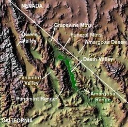 | ||
The Panamint Range is a short rugged fault-block mountain range on the northern edge of the Mojave Desert, in Death Valley National Park, Inyo County, California, United States. The origin of the name is the Paiute word Panümünt.
Contents
Map of Panamint Range, California, USA
Geography
The range runs north-south for approximately 100 miles (160 km) through Inyo County, forming the western wall of Death Valley and separating it from the Panamint Valley to the west. The range is part of the Basin and Range Province, at the western end of the Great Basin.
The highest peak in the range is Telescope Peak with an elevation of 11,049 feet (3,368 m).
Features
Both Mount Whitney and Badwater Basin in Death Valley are visible from some points on the Panamint Range, making it the only location where one can simultaneously see both the highest and lowest points in the contiguous United States.
The historic mining community of Ballarat, now a ghost town, is on the western side of the Panamint Range. The Wildrose Charcoal Kilns ruins are near Wildrose Canyon in the northern area.