
Length 29 km | Counties: Inyo | |
 | ||
East end: SR 190 towards Death Valley | ||
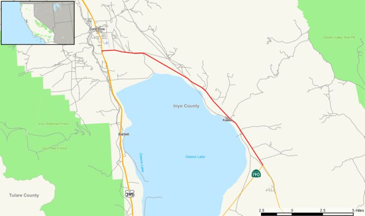
State Route 136 is a short state highway in California, USA, running from Lone Pine to State Route 190 along the northern edge of Owens Lake.
Contents
Route description
This route is part of the California Freeway and Expressway System.
The western terminus of SR 136 is at U.S. Route 395 in Lone Pine, near the Lone Pine Airport. SR 136 heads southeast, crossing through the small towns of Swansea and Keeler as it passes along the north shore of the dry lake Owens Lake. The eastern terminus is at State Route 190 which continues on to Death Valley.
History
SR 136 was adopted as a state route in 1933 as part of Legislative Route 127. It was defined to run from US 99 at Tipton, to US 66 (formerly LRN 31, currently I-15) at Baker. The route would run through Porterville, the Sierra Nevada (only partially constructed), Olancha, and Death Valley. The main line of the route would cross the southeast shore of the Owens Lake. An unsigned branch, also apart of LRN 127 would run along the northeast shore, connecting at US 395 just south of Lone Pine.
In 1964, all of the state routes were renumbered. LRN 127 was divided into three separate state routes. Route 190 became SR 190 over its signed portion. Similarly, Route 127 became SR 127 over its signed portion. The short branch section became a signed route (although poorly signed) as SR 136. The route has not changed since the 1964 renumbering.
Major intersections
Except where prefixed with a letter, postmiles were measured on the road as it was in 1964, based on the alignment that existed at the time, and do not necessarily reflect current mileage. R reflects a realignment in the route since then, M indicates a second realignment, L refers an overlap due to a correction or change, and T indicates postmiles classified as temporary (for a full list of prefixes, see the list of postmile definitions). Segments that remain unconstructed or have been relinquished to local control may be omitted. The entire route is in Inyo County.