
Length 683.7 km | ||
 | ||
Existed: 1928 as US 99, 1964 as SR 99 – present | ||
Driving on california state route 99 from fresno to manteca ca
State Route 99 (SR 99), commonly known as Highway 99 or, simply, as 99 (without any further designation), is a north–south state highway in the U.S. state of California, stretching almost the entire length of the Central Valley. From its southern end at Interstate 5 (I-5) near Wheeler Ridge to its northern end at SR 36 near Red Bluff, SR 99 goes through the densely populated eastern parts of the valley. Cities served include Bakersfield, Delano, Tulare, Visalia, Kingsburg, Selma, Fresno, Madera, Merced, Modesto, Stockton, Sacramento, Turlock, Yuba City, and Chico.
Contents
- Driving on california state route 99 from fresno to manteca ca
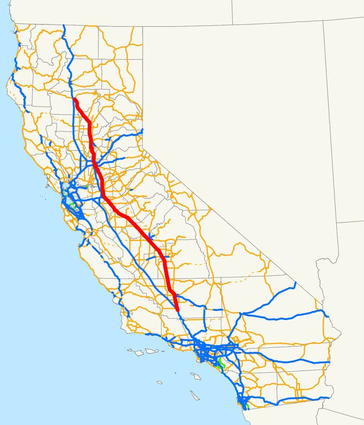
- Map of CA 99 California USA
- Route description
- Wheeler Ridge to Sacramento
- North Sacramento to Red Bluff
- From initial construction to US Route 99
- As a state route
- Future
- Exit list
- References
Map of CA-99, California, USA
The highway is a remnant of the former Mexico to Canada U.S. Route 99 (US 99), which was decommissioned after being functionally replaced by I-5 for long-distance traffic. Almost the entirety of the roadway from Wheeler Ridge to Sacramento has been upgraded as of January 2016 to a freeway at least four lanes wide, and Caltrans plans to further upgrade the segment to a minimum width of six lanes and also bring it into compliance with Interstate Highway standards, as a parallel route to I-5 for Los Angeles–Sacramento traffic. North of Sacramento, the road ranges from a rural two-lane road to a four-lane freeway.
Route description
SR 99 is part of the California Freeway and Expressway System.
Wheeler Ridge to Sacramento
From its southern terminus at I-5 in Wheeler Ridge (Wheeler Ridge Interchange) to Sacramento, SR 99 passes through the major cities of the San Joaquin Valley, including Bakersfield, Delano, Tulare, Visalia, Fresno, Madera, Merced, Modesto, and Stockton. The entirety of this segment is now built to freeway standards with complete access control, although some older portions are not yet in compliance with Interstate Highway standards. The portion of the highway between Fresno and Modesto has been designated the 100th Infantry Battalion Memorial Highway, honoring the US Army unit that was composed almost entirely with American soldiers of Japanese ancestry when it fought during World War II.
The freeway sections connect and serve the agriculture and industry of the California Central Valley, connecting agricultural production with processing and packing businesses. Most of the freeway also parallels the Union Pacific's Fresno Subdivision.
In Sacramento, SR 99 first joins with I-80 Business as part of the Capital City Freeway, then runs concurrently with I-5. These SR 99 concurrences are not officially designated by the California Department of Transportation (Caltrans), but mapmakers often show it as such. SR 99 signage had existed along that route for motorists' convenience, but was removed in 2000, and replaced by TO SR 99 signs instead.
North Sacramento to Red Bluff
SR 99 then splits from I-5 in northern Sacramento, and then heads along the eastern segment of the Sacramento Valley through Yuba City, and Chico to its northern terminus at SR 36 near Red Bluff. A majority of SR 99 from Sacramento to Red Bluff is a two-lane highway, while segments in Yuba City and Chico that are built to freeway standards. SR 99 remains a four-lane freeway as the route leaves Sacramento County, but shortly reverts to a four-lane divided expressway as the highway crosses into Sutter County. As SR 99 reaches the junction of SR 70, the route turns northwest by north and becomes an undivided expressway with the exceptions of crossing the Feather River near Nicolaus and the interchange with SR 113, where the route then turns straight north to Yuba City.
As SR 99 crosses SR 20 as a signaled intersection, the highway becomes a four-lane freeway for 3 miles (4.8 km) before reverting to a two-lane road, passing the smaller towns of Live Oak, Fagan, and Gridley. SR 99 briefly is a local four-lane road through Gridley before continuing as a two-lane highway. SR 99 passes by the western side of the Thermalito Afterbay. SR 162 joins SR 99 for 2 miles (3.2 km) before splitting off east towards the northern end of the Thermalito Afterbay. SR 99 then transitions from a two-lane road to a four-lane divided expressway just before the interchange at SR 149 turning northwest and eventually a freeway entering the Chico city limits. As SR 99 leaves Chico, the highway reverts to a 2-lane road before crossing into Tehama County and passing through rural areas and the town of Los Molinos. The route then curves to the west and terminates at the junction with SR 36, approximately 1.5 miles (2.4 km) from I-5 in Red Bluff.
The portion between Salida and Manteca is designated the 442nd Regimental Combat Team Memorial Highway, honoring the US Army infantry regiment that, like the 100th Infantry Battalion, was also composed almost entirely of American soldiers of Japanese ancestry during World War II.
From initial construction to U.S. Route 99
The first state highway bond issue, approved by the state's voters in 1910, included a north–south highway through the central part of the state consisting of Route 3 through the Sacramento Valley from the Oregon state line south to Sacramento, replacing the Siskiyou Trail, and Route 4 through the San Joaquin Valley from Sacramento to Los Angeles. In addition, a second route followed the west side of the Sacramento Valley, using Route 7 from Red Bluff south to Davis and the short Route 8 east along the proposed Yolo Causeway to Sacramento. North of Bakersfield these closely paralleled some of the main lines of the Southern Pacific Railroad, including the Fresno Line, East and West Valley lines, Shasta Line and Siskiyou Line.
By 1920 paving of both routes from Red Bluff to Los Angeles was completed or in progress, including the only mountain crossing south of Red Bluff, the Ridge Route just north of Los Angeles. To the north of Red Bluff, the road was being graded but not paved over the Siskiyou Mountains into Oregon. Paving was finally completed in mid-1933, when a new alignment (now SR 263) opened through the Shasta River Canyon.
The route from Davis to Oregon via Routes 7 and 3 came to be known as part of the Pacific Highway, an auto trail organized in 1910 to connect Canada and Mexico. The split in the Sacramento Valley was known as the East and West Side highways (the latter also carrying the Pacific Highway). South of Sacramento Route 4 was the Valley Route, but the San Joaquin Valley Tourist and Travel Association held a contest to rename it, selecting Golden State Highway as the winning entry in July 1927. To this day, "Golden State Highway" is SR 99's default name in areas not given other names by the Legislature, and the name continues from its end at Wheeler Ridge on I-5 as the Golden State Freeway from there to downtown Los Angeles.
This north–south central highway became part of US 99 in 1926, as part of the new United States Numbered Highway System developed by the American Association of State Highway Officials (AASHO), though signs were not posted in California until 1928. US 99 also continued southeast from Los Angeles along a paved state highway, Route 9 and 26, to US 80 in El Centro. The paved county road south from El Centro to the Mexican border became a state highway in mid-1931, and part of US 99 in mid-1932.
In mid-1929, AASHO approved a split designation between Sacramento and Red Bluff, with US 99W replacing the original western route via Davis, and US 99E following the East Side Highway (Route 3) via Roseville. A short-lived split also existed between Manteca and Stockton in the early 1930s, with US 99E becoming the main route and US 99W becoming an extended SR 120 where not concurrent with US 50.
A third highway heading north from Sacramento was constructed by the Natomas Company in the 1910s for 13 miles (21 km) along the Sacramento River levee in order to provide access to land reclaimed and sold by the company. Sacramento and Sutter counties continued the road alongside the Sacramento River and Feather River to Nicolaus, where an existing county road crossed the river on a drawbridge and ran north to the East Side Highway at Yuba City. This continuous roadway between Sacramento and Yuba City was dedicated in October 1924 as the Garden Highway.
Parts of the present SR 99 alignment between Sacramento and Yuba City were added to the state highway system in 1933, when the legislature added Route 87 (Sign Route 24, later US 40 Alternate) from Woodland north past Yuba City to northwest of Oroville, and in 1949, with the creation of Route 232 (later Sign Route 24) between Sacramento and Marysville. The final piece became Route 245 (no signed number) in 1959, connecting Route 232 near Catlett with Route 87 near Tudor, and following the old Garden Highway across the Feather River to a point east of Tudor. Despite this combined route connecting the same cities as the Garden Highway, the only other piece of the old county road taken for the state highway was a short segment just north of Sacramento, carrying Route 232 between Jibboom Street and El Centro Road.
As a state route
When the Interstate Highway System was being planned in the 1950s, there were two proposals on which way to route a freeway through the San Joaquin Valley. One was to upgrade US 99 to Interstate standards. The other alternative to build the proposed Westside Freeway, which would bypass all the Central Valley communities and thus provide a faster and more direct north–south route through the state. The latter route, which eventually became I-5, was ultimately chosen.
The implementation of the Interstate Highway System and the mid-1964 state highway renumbering ultimately sealed the fate of the U.S. Highway designation on US 99. The Interstates eventually replaced portions of US 99, causing it to be truncated at both of its ends. Since the remnant did not cross state lines, it was not allowed to keep its U.S. Highway status.
US 99 was truncated to Los Angeles, with the old route south to Mexico becoming mainly I-10 and SR 86. At the same time Route 99 was defined legislatively to run from I-5 near Wheeler Ridge to Red Bluff, but it was only marked as SR 99 between Sacramento and Yuba City, since the remainder was still US 99 or US 99E. The southern end of US 99 was moved further north to Sacramento in late 1966 and SR 99 was extended to Wheeler Ridge; the rest of former US 99 to Los Angeles was either I-5 or the locally maintained San Fernando Road. Several years later US 99 and its branches were removed altogether from California, making SR 99 signage match the legislative definition; all of US 99W, and US 99 north of Red Bluff, remained as other routes (I-80, SR 113, and I-5), while US 99E between Roseville and Marysville became SR 65. By 1968, all US 99 signs were removed or replaced with SR 99 signs following the completion of I-5.
During the latter 20th century, Caltrans gradually widened Route 99 into a four-lane expressway for the entire segment from Wheeler Ridge to Sacramento. As traffic levels on the highway continued to increase, the at-grade intersections on the expressway segments became extremely dangerous. Drivers on cross-streets who needed to cross the expressway often had to wait for several minutes to find suitable gaps in which to dart across heavy through traffic on Route 99 moving perpendicular to them at near-freeway speeds. Therefore, those intersections were gradually upgraded or replaced with freeway interchanges, and frontage roads were often added to provide access to adjoining lots. By 2012, there was only one remaining expressway segment with at-grade interchanges on Route 99 between Sacramento and Wheeler Ridge, in Merced County between the cities of Chowchilla and Atwater. On January 15, 2016, Caltrans officially opened the Plainsburg Road interchange, which completed the conversion of Route 99 south of Sacramento close to a freeway with near-interstate standards.
Future
Caltrans' long-range plans recommend that SR 99 be upgraded to Interstate Highway standards between its southern end and Stockton (or Sacramento), which would require upgrading some substandard sections. Caltrans indicates the route would be designated as either I-7 or I-9, in accordance with the Interstate Highway System's numbering standards (being just east of and parallel to I-5).
Exit list
Except where prefixed with a letter, postmiles were measured on the road as it was in 1964, based on the alignment that existed at the time, and do not necessarily reflect current mileage. R reflects a realignment in the route since then, M indicates a second realignment, L refers an overlap due to a correction or change, and T indicates postmiles classified as temporary (for a full list of prefixes, see the list of postmile definitions). Segments that remain unconstructed or have been relinquished to local control may be omitted. The numbers reset at county lines; the start and end postmiles in each county are given in the county column.