
First system formed January 12, 2016 Total storms 15 Dates 1 Jun 2016 – 30 Nov 2016 Total fatalities 749–1,803 total | Last system dissipated November 25, 2016 Total depressions 16 Hurricanes 7 Location Atlantic Ocean | |
 | ||
Other Instances 2017 Atlantic hurricane, 2015 Atlantic hurricane, 2014 Atlantic hurricane, 2013 Atlantic hurricane, 2012 Atlantic hurricane | ||
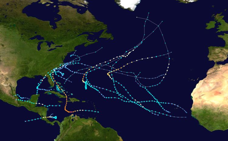
The 2016 Atlantic hurricane season was the first above average Atlantic hurricane season since 2012, producing a total of fifteen named storms, seven hurricanes, and four major hurricanes. The season officially started on June 1 and ended on November 30. The season began nearly five months before the official start, with the first storm, Hurricane Alex, forming in the Northeastern Atlantic in mid-January, the first Atlantic January hurricane since Hurricane Alice in 1955. The final storm, Otto, crossed into the Eastern Pacific on November 25.
Contents
- 2016 atlantic hurricane season animation
- Seasonal forecasts
- Pre season forecasts
- Mid season outlooks
- Hurricane Alex
- Tropical Storm Bonnie
- Tropical Storm Colin
- Tropical Storm Danielle
- Hurricane Earl
- Tropical Storm Fiona
- Hurricane Gaston
- Tropical Depression Eight
- Hurricane Hermine
- Tropical Storm Ian
- Tropical Storm Julia
- Tropical Storm Karl
- Tropical Storm Lisa
- Hurricane Matthew
- Hurricane Nicole
- Hurricane Otto
- Other systems
- Storm names
- Season effects
- References
The strongest, costliest and deadliest storm of the season was Hurricane Matthew, the southernmost Category 5 Atlantic hurricane on record and the first to form since Felix in 2007. With up to 1,657 deaths attributed to it, Matthew may have been the deadliest Atlantic hurricane since Stan of 2005. Furthermore, damage from Matthew is estimated to be at least US$15 billion, making Matthew the ninth costliest Atlantic hurricane in history.
Most forecasting groups predicted above average activity due to a developing La Niña and warmer than normal sea surface temperatures. All of the season's tropical cyclones, except Fiona, Ian and Lisa, impacted land, and nine of those storms caused loss of life, directly or indirectly. Between 749 and 1,803 were killed before the season's end on November 30, the highest number since 2008.
2016 atlantic hurricane season animation
Seasonal forecasts
Ahead of and during the season, several national meteorological services and scientific agencies forecast how many named storms, hurricanes and major hurricanes will form during a season and/or how many tropical cyclones will affect a particular country. These agencies include the Tropical Storm Risk (TSR) Consortium of the University College London, the National Oceanic and Atmospheric Administration (NOAA) and Colorado State University (CSU). The forecasts include weekly and monthly changes in significant factors that help determine the number of tropical storms, hurricanes, and major hurricanes within a particular year. Some of these forecasts also take into consideration what happened in previous seasons and the predicted weakening of the 2014–16 El Niño event. On average, an Atlantic hurricane season between 1981 and 2010 contained twelve tropical storms, six hurricanes, and two major hurricanes, with an accumulated cyclone energy (ACE) index of between 66 and 103 units.
Pre-season forecasts
The first forecast for the year was issued by CSU on December 10, who anticipated that one of four different scenarios could occur. TSR subsequently issued their first outlook for the 2016 season during December 16, 2015 and predicted that activity would be about 20% below the 1950–2015 average, or about 15% below the 2005–2015 average. Specifically they thought that there would be 13 tropical storms, 5 hurricanes, 2 major hurricanes and an ACE index of 79 units. A few months later, TSR issued their second prediction for the season during April 6, 2016 and lowered the predicted number of named storms to 12 but raised the number of hurricanes to 6. On April 14, CSU predicted that the season would be near-normal, predicting 13 named storms, 6 hurricanes and 2 major hurricanes with ACE near 93. On April 15, North Carolina State University predicted the season would be very active, with 15-18 named storms, 8-11 hurricanes and 3-5 major hurricanes. A month later, the United Kingdom Met Office (UKMO) released its forecast, predicting a slightly above-average season with 14 named storms and 8 hurricanes. It also predicted an ACE index of 125, above the defined average ACE index at 103. On May 27, NOAA issued its first outlook calling for a near-normal season with a 70% chance that 10-16 named storms could form, including 4-8 hurricanes of which 1-4 could reach major hurricane status. NOAA also stated that there is a 45% chance of a near-normal season, 30% chance of an above-normal season and 25% chance of a below-normal season. Also on May 27, TSR substantially increased their forecast numbers, predicting activity would be about 30% above the average with 17 named storms, 9 hurricanes, 4 major hurricanes and an ACE near 130. The reason for the increased activity forecast was the increased likelihood of La Niña forming during the season in addition to a trend towards a negative North Atlantic Oscillation, which generally favors a warmer tropical Atlantic. TSR predicted that there is a 57% chance that the 2016 Atlantic season would be above-normal, a 33% chance it would be near-normal, and only a 10% chance it would be below-normal.
Mid-season outlooks
CSU updated their forecast on June 1 to include 14 named storms, 6 hurricanes and 2 major hurricanes to include Tropical Storm Bonnie. It was again updated on July 1 to include 15 named storms, 6 hurricanes and 2 major hurricanes, to accommodate for tropical storms Colin and Danielle. On July 5, TSR released their fourth forecast for the season, slightly lowering the predicted numbers to 16 tropical storms, 8 hurricanes and 3 major hurricanes. On August 5, TSR released their final forecast for the season, lowering the numbers to 15 named storms and 7 hurricanes due to the influence that La Niña being less than anticipated previously.
The 2016 Atlantic hurricane season officially began on June 1, 2016. It was an above average season that was the most active since 2012, producing a total of 15 named storms, 7 hurricanes and 4 major hurricanes. The first storm, Hurricane Alex, developed on January 12, while the final system, Hurricane Otto, made a crossover to the Eastern Pacific on November 25.
The higher-than-normal activity was attributed to many factors. The most significant one however was the rapid dissipation of one of the strongest El Niño events recorded in history, which transformed to cool neutral conditions across the Pacific in late summer. This led to warmer then normal sea surface temperatures across the Atlantic (with the expectation of the subtropical regions, which were slightly cooler then normal), slightly lower then normal sea level pressures, and reduced wind shear, especially in the Caribbean, which had experienced record values of wind shear in the past recent years. Moisture levels however were anomalously dry, which likely caused some of the storms from becoming significant hurricanes. Steering currents had also been different from past years, which had previously had a trough of low pressure dominating the East Coast of the United States. Overall, these and some other factors led to the Atlantic being more favorable then it had been over the past few years, which was mostly dominated by unfavorable conditions which had led to lower seasonal totals.
The year opened up with an anomalous storm in January: Hurricane Alex, the first such system to develop in January since 1938. Activity picked up at the end of May into June, with three consecutive tropical storms: Bonnie, Colin, and Danielle. The latter two were the earliest third- and fourth-named storms on record. July saw no storm development for the first time in four years, however. August saw the formation of five tropical cyclones: Earl, Fiona, Gaston, Eight, and Hermine. A Category 1 hurricane, Earl wrought tremendous damage in Belize and Mexico. With 81 lives lost in Mexico during the passage of Earl, it was the deadliest in the country since Hurricane Stan in 2005. Gaston became the season's first major hurricane on August 28, attaining peak winds of 120 mph (195 km/h) over the central Atlantic. On September 1 Hermine struck the Florida Peninsula, ending an 11-year drought of hurricane landfalls in Florida.
September featured another five tropical cyclones: Ian, Julia, Karl, Lisa, and Matthew, the latter of which persisted into October. Matthew proved to be the most significant storm of the season, becoming the first Category 5 hurricane in the Atlantic since Hurricane Felix in 2007. It subsequently struck Haiti as a Category 4 hurricane, and inflicted catastrophic damage across the impoverished nation. Matthew also caused extensive damage in Cuba, The Bahamas, and the Southeastern United States. Concurrently, Hurricane Nicole meandered south of Bermuda for more than a week before making a direct hit on the territory as a major hurricane. The next four weeks were quiet, until Hurricane Otto formed in the southwestern Caribbean during late November. Otto eventually became the latest-forming major hurricane in the Atlantic basin on record, surpassing a storm in 1934. After striking Nicaragua and becoming the first hurricane on record to pass over Costa Rica, Otto then emerged into the Eastern Pacific basin, the first such occurrence since Hurricane Cesar–Douglas in 1996. The Atlantic hurricane season officially ended on November 30, 2016.
The season's above-normal activity was reflected with an Accumulated Cyclone Energy Index of 138.3075 units. This is the highest value since 2010 and well above the 1951–2000 full-season average of 93 units.
Hurricane Alex
A weak area of low pressure developed over northwestern Cuba in association with a stationary front on January 6. The frontal wave intensified as it moved into the central Atlantic, temporarily attaining hurricane-force winds by January 10. Steered by anomalous high pressure, the disturbance turned southeast and tracked over warmer waters. Its associated fronts dissipated, its wind field became more symmetric, and convection increased near the center, leading to the formation of Subtropical Storm Alex by 18:00 UTC on January 12. Despite marginal ocean temperatures, Alex benefited from rapidly cooling upper-air temperatures, and it intensified quickly while turning northeast. The presence of deeper convection and an eye on conventional satellite showcased the storm's transition into a fully tropical cyclone and intensification into a hurricane by 06:00 UTC on January 14. Six hours later, it peaked with maximum sustained winds of 85 mph (140 km/h). Alex turned north after peak, and the storm weakened to a tropical storm before making landfall on Terceira Island, Azores. With decreasing core convection and an impinging warm front, Alex transitioned into an extratropical cyclone by 18:00 UTC on January 15 and was absorbed by a larger extratropical low two days later.
The precursor disturbance to Hurricane Alex produced gusts up to 60 mph (97 km/h) on Bermuda, as well as swells up to 20 ft (6 m) offshore; this disrupted air travel, downed trees, caused sporadic power outages, and suspended ferry services. In the Azores, the cyclone produced maximum rainfall accumulations up to 4.04 in (103 mm) in Lagoa. Peak gusts of 57 mph (92 km/h) affected Ponta Delgada, causing minor to moderate damage. Landslides also contributed to minor damage. One death occurred when a victim that suffered a heart attack was unable to be airlifted to a hospital due to unsettled conditions.
Tropical Storm Bonnie
An area of low pressure developed into Tropical Depression Two at 18:00 UTC on May 27, while situated about 205 mi (330 km) northeast of Great Abaco in the Bahamas. Moving steadily west-northwestwards, Bonnie intensified into a tropical storm on May 28. Shortly thereafter, the storm reached its peak winds of 45 mph (75 km/h). However, due to hostile environmental conditions, Bonnie weakened to a depression hours before making landfall just east of Isle of Palms, South Carolina, on May 29. Steering currents collapsed afterwards, causing the storm to meander over South Carolina for two days. The storm weakened further into a non-tropical remnant low on May 31, before emerging off the coast while moving generally east-northeastwards. On June 2, Bonnie regenerated into a tropical depression just offshore North Carolina as conditions became slightly more favorable. The next day, despite increasing wind shear and cooling sea surface temperatures, Bonnie reintensified into a tropical storm and reached its minimum barometric pressure of 1,006 mbar (29.7 inHg). The storm weakened to a tropical depression late on June 4 and became a non-tropical low again early the next day to the north of Bermuda. The remnants moved east-southeast until dissipated on June 9.
Rip currents along the coastline of the Southeast United States led to dozens of water rescues; the body of one 20-year-old man was recovered in Brevard County, Florida, after he drowned, Lingering over South Carolina for a few days, Bonnie brought heavy rains and widespread floods to the Southeastern United States. Rainfall totals hit 6 in (150 mm) in much of South Carolina, and exceeded 10 in (250 mm) in some areas. Flooding resulted in the closure of the southbound lanes of Interstate 95 in Jasper County, and also inundated the Jasper County Sheriff’s Office and Detention Center. In Ridgeland, several buildings were damaged and the local wastewater treatment plant overflowed, spilling discharge into the nearby Captain Bill Creek. Damage in this county alone exceeded $640,000. Record-breaking rainfall was observed across much of the Outer Banks; on Hatteras Island, Cape Point Campground was closed for a week due to flooding. Two people drowned in rip currents along the coastline of the Southeast United States. In North Carolina, the body of a 21-year-old man was recovered in New Hanover County, several days after he went missing.
Tropical Storm Colin
On May 27, a tropical wave exited the coast of Africa. By early June, the wave entered the Caribbean Sea and spawned a low pressure system. The low remained disorganized with only isolated convection, mostly in the eastern quadrant. Convection began to wrap into the center as the storm curved northward into the Gulf of Mexico on June 3. After the low passed over the Yucatán Peninsula on June 5, the National Hurricane Center upgraded it to Tropical Depression Three and tropical storm warnings were issued for the Big Bend region of Florida. Later that day, the depression intensified into Tropical Storm Colin, just after tropical storm watches were put in place for eastern Florida and Georgia. The formation into a tropical storm marked the earliest formation on record of the third named storm within the Atlantic basin, exceeding the previous record set in 1887 by seven days. Gradually curving northeastwards, Colin remained disorganized as it accelerated towards the coast of Florida on June 6; in their forecast discussion, the NHC noted that their uncertainty in locating the circulation center, instead taking the midpoint between two small-scale circulations. However, a strong burst of convection increased the winds to 50 mph (85 km/h). Maintaining its intensity, Colin continued accelerating to the northeast and made landfall in the Big Bend region just after 03:00 UTC on June 7. Failing to weaken over land, Colin began undergoing extratropical transition after the increasingly ill-defined circulation moved off the coast of Georgia, and became fully extratropical hours later.
Much of Florida experienced heavy rainfall, and flash flood and tornado warnings were issued. At least three people drowned along the Florida Panhandle due to rip currents, and a fourth disappeared and was presumed dead. Damage from Colin in the Tampa Bay area totaled $10,000 (2016 USD).
Tropical Storm Danielle
A tropical wave emerged off the western coast of Africa on June 8, reaching the southwestern Caribbean Sea by June 15. Convection increased that day, and further organized after the system entered the Bay of Campeche three days later, subsequently leading to the formation of a tropical depression by 12:00 UTC on June 19. Steered west-northwest and then northwest by a mid-level ridge, the depression intensified into Tropical Storm Danielle by 06:00 UTC on June 20 and attained peak winds of 45 mph (75 km/h) six hours later. Interaction with land began to weaken the storm a few hours later, and Danielle made landfall near Tamiahua, Mexico with winds of 40 mph (65 km/h). The storm rapidly weakened as it moved inland, falling to tropical depression intensity by 00:00 UTC on June 21 and degenerating into a remnant low six hours later. The remnant low continued inland before dissipating over the mountains of eastern Mexico that same day.
A tropical storm warning was issued from the coast of Mexico from Laguna Verde to Rio Paranuco. It was later discontinued when Danielle moved ashore and rapidly weakened. Danielle dropped heavy rainfall across the affected regions, particularly the areas near Veracruz and Tamiahua. Official amounts were not reported, however the maximum rainfall that was observed was around 6.22 in (158 mm) at Cosaultán de Carvajal. The cyclone also brought wind gusts up to 45 mph (72 km/h), reported near Tampico. Across much of Veracruz, officials suspended school activities and the port of Veracruz was temporarily closed. Flooding in the Pueblo Viejo Municipality affected 1,200 families and prompted activation of public shelters. A homeless man drowned in a storm drain in Ciudad Madero, Tamaulipas, after flash flooding impacted the area.
Hurricane Earl
The NHC began monitoring a tropical wave in the central Atlantic on July 28. The disturbance's rapid movement prevented development for several days until it passed Jamaica on August 2, when a reconnaissance aircraft confirmed the presence of a closed circulation; already possessing tropical storm-force winds, it was upgraded to Tropical Storm Earl. Steered generally westward by a ridge over the South United States, Earl intensified amid warm ocean temperatures and low shear, attaining hurricane intensity and peaking with winds of 85 mph (140 km/h) on August 3. Earl made landfall just southwest of Belize City, Belize, around 06:00 UTC on August 4. It quickly weakened over land, although it emerged over the southern Bay of Campeche the following day while still maintaining minimal tropical storm intensity. A Hurricane Hunters mission flew into Earl later on August 5, unexpectedly measuring 60 mph (95 km/h) winds. The cyclone maintained these winds up to landfall just south of Veracruz, Veracruz, around 02:00 UTC on August 6. Once inland, Earl quickly weakened and the storm's circulation dissipated by 15:00 UTC.
The precursor to Earl brought heavy rain and gusty winds to the Lesser Antilles and Greater Antilles. Strong winds in the Dominican Republic downed a power line onto a bus, subsequently causing a fire that killed six people. A boat crash in Samaná Bay killed seven people. Significant impacts were reported in Belize after Earl moved ashore as a hurricane, including downed trees and power lines, blown transformers, damaged or ripped-off roofs, coastal and inland flooding, and a significant storm surge. Landslides in Mexico following the storm's second landfall resulted in an additional 54 deaths.
Tropical Storm Fiona
Late on August 14, the NHC began monitoring a tropical wave and its associated convection off the western coast of Africa for potential development. Steered northwest toward a weakness in the subtropical ridge over the central Atlantic, the wave organized sufficiently to be declared a tropical depression by 03:00 UTC on August 17. However, in post-analysis, it was revealed Fiona formed slightly earlier then what was operationally shown - it had developed around 18:00 UTC on August 16. The depression slowly organized after formation, and the development of a central dense overcast feature prompted an upgrade to Tropical Storm Fiona by 21:00 UTC on August 17. Despite strong westerly shear, abundant mid-level dry air, and an otherwise disheveled satellite appearance, an ASCAT pass showcased Fiona's peak intensity with winds of 50 mph (85 km/h) around 03:00 UTC on August 20. Although sporadic bursts of convection continued amid the hostile environment, Fiona weakened to a tropical depression by 03:00 UTC on August 22 and degenerated into a remnant low early on August 23.
Hurricane Gaston
On August 17, the NHC highlighted the potential for tropical cyclone development off the western coast of Africa in subsequent days. A weak area of low pressure associated with a tropical wave emerged into the eastern Atlantic three days later, and the disturbance steadily coalesced into a tropical depression by 12:00 UTC on August 22. The newly formed depression organized while headed northwest, intensifying into Tropical Storm Gaston six hours after classification and attaining hurricane intensity by 12:00 UTC on August 24 in accordance with data from the NASA Global Hawk unmanned aircraft and satellite data. After its initial peak in intensity, Gaston's satellite appearance began to degrade as an upper-level low imparted strong southwesterly shear on the cyclone, causing it to weaken back to a tropical storm. Upper-level winds slackened early on August 27, and a timely microwave pass highlighted the presence of a low-level eye well embedded in the storm's central dense overcast, indicating the resumption of Gaston's intensification phase.
Although the cyclone continued its northwest heading, its motion slowed in a weak steering regime. Amid low shear and warm ocean temperatures, Gaston attained hurricane intensity for a second time by 18:00 UTC on August 27 and further intensified to become a Category 3 hurricane, the first major hurricane of the season, by 18:00 UTC the next day. With a symmetric ring of deep convection surrounding a distinct eye, Gaston ultimately peaked with sustained winds of 120 mph (195 km/h) six hours later. A mid-level trough moving southeastward across the North Atlantic eroded a series of ridges steering Gaston, causing the system to drift north and northeast. Cold water upwelling, concurrent with an eyewall replacement cycle, caused Gaston to weaken on August 29, although unexpected re-intensification allowed Gaston to attain its peak winds of 120 mph (195 km/h) for a second time by 00:00 UTC on August 31. Later that day, Gaston began to enter increasingly cool waters and a higher shear environment and slowly degraded: it fell below major hurricane status by 18:00 UTC on August 31, and weakened below hurricane intensity by 12:00 UTC on September 2. Soon after, the continued unfavorable conditions caused deep convection to dissipate, and Gaston transitioned to a post-tropical cyclone as its center grazed Flores Island at 18:00 UTC that day. Gaston's remnant circulation dissipated 24 hours later northwest of the Azores.
Tropical Depression Eight
On August 25, a frontal boundary which had previously absorbed the remnant circulation of Tropical Storm Fiona, stalled near Bermuda. The front weakened the next day and a broad area of low pressure formed on the southwestern tail of this boundary late on August 26. By 00:00 UTC on August 27, the low became well-defined, however, it lacked sufficient thunderstorm activity to be classified, as it was sparse and disorganised. At this time, the National Hurricane Center (NHC) only assessed a low (<40%) chance of development, citing unfavourable conditions such as dry air entrainment and moderate wind shear, although the associated thunderstorms produced winds of 35 mph (55 km/h). However, a sudden and unexpected burst of convection near and to the west of the center prompted the upgrade to Tropical Depression Eight at 12:00 UTC on August 28 about 350 miles (560 km) southeast of Cape Hatteras, North Carolina, based on satellite data and a recent ASCAT pass that revealed winds of tropical depression strength. Operationally, it was not classified as a depression until 15:00 UTC.
A ridge to the north steered the nascent depression westward into an area of moderate wind shear that precluded initial development. Late on August 28, the center became exposed from the convection. By 24 hours later though, the thunderstorms increased and developed into banding features. On August 28, the NHC issued a tropical storm watch for the Outer Banks of North Carolina from Cape Lookout to Oregon Inlet, which was upgraded to a tropical storm warning on the next day. As it approached the Carolina coastline on August 30, a weakeness in the subtropical ridge it was steered by caused it to slow down and turn northward; its closest approach to the United States was 60 miles (97 km) south-southeast of Cape Hatteras later that day. Afterwards, the depression then turned eastwards in response to becoming entangled in the mid-latitude westerlies. As it accelerated, the circulation began to become elongated, signifying the beginning of a weakening trend. The depression then eventually opened up into a trough of low pressure by 00:00 UTC on September 1. Shortly afterwards, the remnants of the depression were absorbed into a frontal system on September 2.
As the depression approached the coastline, residents began to prepare for a possible landfall. In response, a Tropical Storm Watch was issued for Cape Lookout to Oregon Inlet, North Carolina early on August 29. This was later upgraded to a warning with the addition of including the Pamlico Sound in anticipation of the depression strengthening into a tropical storm. However, as the depression failed to intensify and moved away from the coastline, the warnings were discontinued at 00:00 UTC August 31. Effects from the system were relatively minimal, with only reports of some rainfall, gusty winds and minor surf in the Outer Banks.
Before the depression formed, its precursor low had caused some effects in Bermuda. On August 24, the disturbance had dropped about 1.17 inches (3.0 cm) on rainfall, triggering some localized flooding. Winds were relatively light, though. The next few days remained unsettled, as the disturbance brought a further 0.23 inches (0.58 cm) of rain to the island nation, before finally moving away and acquiring tropical characteristics.
Hurricane Hermine
On August 18, the NHC first noted a tropical wave southwest of Cape Verde as a potential area for development. On August 24, the system crossed Guadeloupe into the Caribbean Sea while producing gale-force winds. Marginal wind shear disrupted the system's organization, and the system crossed the southern Bahamas with scattered convection. While in its developmental stages, the precursor low dropped 3 to 5 in (76 to 127 mm) of rainfall across northern Cuba. In Batabanó on Cuba's southern coast, the southerly winds and 8.5 in (215 mm) of rainfall caused moderate flooding. On August 28, the convection increased and became more organized, and the NHC initiated advisories on Tropical Depression Nine at 21:00 UTC about halfway between the Florida Keys and the north coast of Cuba. On August 31, an impressive burst of thunderstorm activity around the center plus an increase of wind speed to 40 mph (64 km/h) was enough to finally classify the depression as a tropical storm, and was named Hermine. Despite only marginal favorable conditions, Hermine rapidly intensified into a Category 1 hurricane and accelerated northeastwards, nearing the Big Bend area, making it the first hurricane to form in the gulf since Ingrid in 2013. After making landfall on September 2, Hermine's circulation degraded. A few hours after exiting the coast, Hermine weakened into a depression and began extratropical transition. Hermine completed the transition early on September 3, and began restrengthening, as the forward motion of the storm slowed.
Tropical Storm Ian
On September 5, the NHC indicated that the development of a tropical cyclone was possible in the East Atlantic over subsequent days. A tropical wave emerged off the western coast of Africa the next morning, slowly coalescing into Tropical Storm Ian by 06:00 UTC on September 12. Steered north and the northeast by an approaching upper-level trough, the cyclone struggled within an environment of high shear, with its low-level center displaced west of its associated convection. An upper-level low became superimposed with the storm's center by late on September 14, yielding a more subtropical-like appearance on conventional satellite, and Ian briefly transitioned into a subtropical storm late that night. However, it was able to re-acquire tropical characteristics just 18 hours later when it moved northeastwards away from the aforementioned low. By 06:00 UTC on September 16, a small mid-level eye became apparent and Ian began to intensify, with winds reaching 60 mph (95 km/h) at that time. However, deep convection soon dissipated as cold air wrapped into the center, marking Ian's transition into an extratropical cyclone. The next day, Ian's remnants were absorbed by an even larger extratropical cyclone and thusly dissipated.
Tropical Storm Julia
Early on September 8, a concentrated area of shower and thunderstorm activity developed in association with a broad low east of the Leeward Islands. The disturbance increased in organization as it passed through the northwestern Bahamas late on September 12, but further development was not expected at the time. By 03:00 UTC on September 14, however, the system maintained sufficient organization to be declared Tropical Storm Julia, the first tropical cyclone on record to form over Florida. Following formation, the cyclone drifted northwards and then east offshore the Southeastern United States in a weak steering regime. A cyclonic loop occurred as strong westerly air developed in the region. The shear caused Julia to periodically fluctuate in intensity. This was also marked by periodic bursts of convection around the already disorganized center. By 03:00 UTC By September 19, the center of Julia had been devoid of strong convection, as rainbands began to rapidly diminished. By 03:00 UTC that day, Julia degraded into a remnant low. The remnants of the storm continued to drift, bringing more rain to the region.
Parts of North Carolina received as much as a foot of rain, while as much as 18 inches fell in the Hampton Roads area of Virginia. 63 people had to be rescued from their homes, and 61 were evacuated from nursing homes. One million gallons of sewage from Elizabeth City flowed into the Pasquotank River and Charles Creek. The Cashie River in Windsor, North Carolina, reached 15 feet on September 22, 2 feet above flood stage. That same day, Gov. Pat McCrory declared a state of emergency in 11 counties. Bertie, Currituck and Hertford Counties in North Carolina closed schools.
Tropical Storm Karl
The NHC began monitoring a tropical wave off the western coast of Africa on September 12. Steered west-northwest and then west, it steadily organized while passing through the Cabo Verde Islands, and the wave attained sufficient organization to be declared a tropical depression by 06:00 UTC on September 14. The effects of strong shear plagued the cyclone after formation, with its low-level circulation misplaced from the associated shower and thunderstorm activity. By 06:00 UTC on September 15, however, a significant burst of deep convection prompted the depression's upgrade to Tropical Storm Karl. The cyclone continued west for several days across the unfavorable central Atlantic, with convection sheared to the northeast and the circulation occasionally becoming poorly defined. Karl eventually weakened to a tropical depression by 06:00 UTC on September 21 as it passed close to an upper-level low. By the next afternoon, however, the upper-level low moved away to the south, causing a reduction in shear that allowed the system to reattain tropical storm intensity as it curved near Bermuda. Accelerating east-northeastwards, Karl continued to strengthen and it attained peak winds of 70 mph (110 km/h) early on September 25. However, cold air encroached on the low-level circulation by 12:00 UTC that day, marking Karl's transition to an extratropical cyclone. Karl's remnant low continued northeast over the North Atlantic and was absorbed by another extratropical system early on September 26.
On Bermuda, about 800 people lost power indirectly from the storm due to a mainline fault on the island. Otherwise, impacts on the island were relatively minimal. The maximum winds recorded were 34–52 mph (55–84 km/h) and gusts to over 62 mph (100 km/h). Along the east coast of the United States, long-period swells from Karl were recorded as it moved out to sea.
Tropical Storm Lisa
On September 14, the NHC noted the potential for tropical cyclone development in the East Atlantic later in the week. A tropical wave moved off the western coast of Africa two days later, developing into a tropical depression by 21:00 UTC on September 19. Then, on September 20, it strengthened to Tropical storm Lisa. At 09:00 UTC September 22, Lisa reached peak intensity of 50 mph (85 km/h) and a minimum pressure of 999 mbar. The storm started to weaken soon after due to increasing wind shear, but restrengthened a day later. Lisa managed to maintain tropical storm intensity while battling unfavorable conditions until September 23, where at 21:00 UTC the storm weakened to a tropical depression. Lisa became a remnant low at 03:00 UTC on September 25, and the National Hurricane Center issued their final advisory on the system. The remnants of Lisa were monitored for potential regeneration, but the remnants failed to redevelop and dissipated soon after.
Hurricane Matthew
On September 22, the NHC highlighted a tropical wave emerging off the western coast of Africa for potential development. The wave moved swiftly westward while coalescing, and although it initially struggled to develop a closed surface circulation, the disturbance acquired sufficient organization to be declared Tropical Storm Matthew by 15:00 UTC on September 28 just southeast of Saint Lucia. Continuing westward under the influence of a mid-level ridge, the storm steadily intensified to attain hurricane intensity by 15:00 UTC on September 29 despite a partially exposed center. The effects of southwesterly wind shear unexpectedly abated late that day, and Matthew began a period of rapid intensification; from a 24-hour period beginning at 03:00 UTC on September 30, the cyclone's maximum winds doubled, from 80 mph (130 km/h) to 160 mph (260 km/h), making Matthew a Category 5 hurricane – the first hurricane to reach this strength in the North Atlantic basin since Felix in 2007. The storm's small eye became less distinct early on October 1, prompting the NHC to downgrade Matthew to a Category 4 hurricane. Matthew remained a powerful Category 4 hurricane for several days, making landfall in Haiti around 11:00 UTC on October 4, and Cuba around 00:00 UTC on October 5. Cuba's and Haiti's mountainous terrain weakened Matthew into a Category 3, as it began to accelerate northwestwards, through the Bahamas. Restrengthening occurred as Matthew's circulation became better organized, with the storm passing Freeport with winds of 140 mph, making the storm a Category 4 hurricane again. Concentric eyewalls were noted at this time, thus, Matthew began to weaken as an eyewall replacement cycle began. Matthew began to decelerate soon after, with its weakened eye passing about 12 miles east of Melbourne, Florida, on October 6 with winds of 130 mph. Matthew continued to drift northwards, passing east of Georgia as a Category 3, and finally, Matthew made landfall at around 11:00 a.m. EDT (15:00 UTC) on 8 October at Cape Romain National Wildlife Refuge, near McClellanville, South Carolina, as a Category 1 hurricane with winds of 75 mph (120 km/h). Convection became displaced as Matthew pulled away from land, and the NHC declared that Matthew had become post-tropical, 11 days after the storm's first advisory.
One person died in St. Vincent when he was crushed by a boulder. Another person drowned in a river due to heavy rains in Uribia, La Guajira, in Colombia. In total, up to 1,659 deaths have been attributed to the storm, including 1,600 in Haiti, making it the deadliest Atlantic hurricane since Stan in 2005, which killed more than 1,600 in Central America and Mexico.
Hurricane Nicole
On September 25, a tropical wave moved off the coast of Africa, with moderate amounts of thunderstorm activity. Development was not anticipated as the wave lost most of its convection as it progressed westward. By October 1, the NHC began monitoring the tropical wave in the central Atlantic for possible tropical development as it began to turn northwestward. Still, development was considered unlikely due to wind shear from the outflow of Hurricane Matthew, which was situated to its west. However, on October 4, an ASCAT pass revealed the presence of a well-defined surface circulation and winds of up to 50 mph (85 km/h), and the NHC initiated advisories on Tropical Storm Nicole at 15:00 UTC that day. The NHC forecast only gradual strengthening as the storm moved slowly to the north due to weak steering currents. An eye then began to become visible at both mid- and upper-level heights, and Nicole rapidly strengthened to a Category 2 hurricane to the south of Bermuda, peaking at winds of 105 mph (165 km/h) and a pressure of 968 mbar (28.59 inHg). With Matthew much stronger at that time, this was the first time since 1964 that two hurricanes at or above Category 2 existed simultaneously in the Western Atlantic Ocean (65°W).
Nicole peaked in intensity and then stalled, and immediately wind shear finally began to take its toll; with the eye no longer visible and convection diminishing, Nicole rapidly weakened to a high-end tropical storm on October 7. Further weakening continued as it drifted southward, and by October 8, the cyclone's circulation was exposed and it was barely a tropical storm, with all convection displaced to the south. Later that evening an impressive burst of convection flared up over the center, and Nicole again became more organized as it began to turn to the north. Gradual intensification continued throughout the next few days before briefly stopping, then later resuming on October 11 as the storm turned towards Bermuda and re-strengthened to Category 1 status. On October 12, Nicole became a Category 2 hurricane again. Later on the same day, Nicole became the third major hurricane of the season when it strengthened to a Category 3 hurricane. The next day, Nicole briefly strengthened into a Category 4 hurricane; but weakened back to a Category 3 hurricane several hours later due to increasing vertical wind shear. At 15:00 UTC on October 13, the hurricane's eye passed directly over Bermuda, where automated surface station measured sustained winds of 87 mph (141 km/h) and a gust reaching 119 mph (191 km/h). At 09:00 UTC on October 14, southwesterly wind shear reduced the system to Category 1 status, although swells from Nicole continue to affect Bermuda and portions of the U.S. east coast and Atlantic Canada. In the early morning of October 15, Nicole weakened to a tropical storm but was expected to slightly restrengthen throughout the day. At 15:00 UTC that same day, Nicole restrengthened into a hurricane at a high latitude, eventually becoming one of the largest Atlantic hurricanes on record. Nicole slowly began to weaken the next day, and weakened to a tropical storm early on October 18. Nicole transitioned into a post-tropical cyclone at 09:00 UTC later that day.
Hurricane Otto
On November 14, an area of disturbed weather formed in the southwestern Caribbean Sea. Drifting for nearly a week, the weather system had a well-defined circulation and organized convection. The NHC designated it as Tropical Storm Otto on November 21 off the east coast of Nicaragua. Fueled by warm waters and good outflow, Otto intensified into a hurricane on the 23rd while drifting westward; this was the latest date for a tropical cyclone to reach that intensity over the Caribbean Sea, one day later than the previous record set by Hurricane Martha in 1969. Otto rapidly intensified throughout following day, and at 17:30 UTC November 24, the storm made landfall on the southern Nicaragua coast near San Juan de Nicaragua at peak intensity, as a Category 3 major hurricane with winds of 115 mph (185 km/h). With this, Otto became the southernmost hurricane to make landfall in Central America. Weakening ensued as Otto moved inland. Around 03:30 UTC on November 25, Otto exited into the Eastern Pacific, marking the first time a tropical cyclone survived the crossover from the Atlantic to the Eastern Pacific since Hurricane Cesar–Douglas in 1996.
Other systems
On September 15, Météo-France began monitoring a cyclone in the Bay of Biscay that they claimed was subtropical, having apparently possessing an asymmetric wind field of tropical-storm force winds and a warm thermal core. The system drifted southeastwards, attaining a peak intensity of 996 millibars (29.4 inHg), and eventually made landfall near the border of Spain and France, rapidly weakening and eventually dissipating shortly thereafter early on September 16. The Free University of Berlin, in accordance with their naming of cyclones that affect their area, named the cyclone "Stephanie". In some areas along the coastline, winds gusted up to 120 km/h (75 mph), however damage was relatively minimal.
Storm names
The following list of names was used for named storms that formed in the North Atlantic in 2016. Retired names, if any, will be announced by the World Meteorological Organization in the spring of 2017. The names not retired from this list will be used again in the 2022 season. This was the same list used in the 2010 season, with the exception of Ian and Tobias, which replaced Igor and Tomas, respectively. The name Ian was used for the first time this year.
Season effects
This is a table of all the storms that formed in the 2016 Atlantic hurricane season. It includes their duration, names, landfall(s), denoted in parentheses, damages, and death totals. Deaths in parentheses are additional and indirect (an example of an indirect death would be a traffic accident), but were still related to that storm. Damage and deaths include totals while the storm was extratropical, a wave, or a low, and all the damage figures are in 2016 USD.