
Formed September 8, 2010 Fatalities 4 direct | Dissipated September 23, 2010 Highest winds 249 km/h | |
 | ||
Lowest pressure 924 mbar (hPa); 27.29 inHg Damage $200 million (2010 USD) Areas affected Cape Verde, Northeastern Caribbean, Eastern United States, Bermuda, Newfoundland, Saint Pierre and Miquelon Date 8 September 2010 – 23 September 2010 Similar Hurricane Julia, Hurricane Earl, Hurricane Karl, Hurricane Danielle, Hurricane Tomas | ||
Hurricane igor grotto bay bermuda september 18 19 2010
Hurricane Igor was the most destructive tropical cyclone on record to strike the Canadian island of Newfoundland. Igor originated from a broad area of low pressure that moved off the west coast of Africa on September 6, 2010. Tracking slowly westward, it developed into a tropical depression on September 8 and strengthened into a tropical storm shortly thereafter. Higher wind shear temporarily halted intensification over the following days. On September 12, explosive intensification took place, and Igor reached Category 4 status on the Saffir–Simpson Hurricane Wind Scale. By this time, Igor had already begun a prolonged turn around the western periphery of the subtropical ridge. Peaking with winds of 155 mph (250 km/h), the cyclone began to enter an area unfavorable for continued strengthening, and Igor gradually weakened before brushing Bermuda as a minimal hurricane on September 20. After turning northeastward, the system began an extratropical transition, which it completed shortly after striking southern Newfoundland. The remnants of Igor were later absorbed by another extratropical cyclone over the Labrador Sea on September 23.
Contents
- Hurricane igor grotto bay bermuda september 18 19 2010
- Hurricane igor approach time lapse 8x bermuda september 17 18 2010
- Meteorological history
- Cape Verde and Leeward Islands
- United States
- Bermuda
- Canada
- Aftermath
- Retirement
- References
While the hurricane was over the open ocean, it produced large swells that caused the deaths of three people — two in the Caribbean and one in the United States. As it passed west of Bermuda as a minimal hurricane, damage was limited primarily to trees and power lines, with roughly 27,500 residences losing electricity. Total losses in the territory were less than US$500,000. However, in Newfoundland, Igor wrought extreme damage, claimed to be the worst ever seen in some areas. Large stretches of roadways were completely washed out by flooding, including a portion of the Trans-Canada Highway, isolating approximately 150 communities. Throughout the region, one person was killed and damage costs amounted to a record C$200 million. In the storm's wake, military personnel were deployed to assist in recovery efforts and aid distribution.
Hurricane igor approach time lapse 8x bermuda september 17 18 2010
Meteorological history

Hurricane Igor was first identified as a broad area of low pressure accompanying a tropical wave over western Africa in early September 2010. Tracking nearly due west, the system emerged into the eastern Atlantic Ocean on September 6. Gradual development took place as convection – thunderstorm activity – consolidated around its center. At 0600 UTC on September 8, the low was deemed sufficiently organized to be classified as a tropical depression while situated roughly 90 mi (140 km) southeast of the Cape Verde Islands. Attaining gale-force winds six hours later, the depression intensified into a tropical storm and was subsequently named Igor by the National Hurricane Center (NHC).
Development of Igor quickly ceased once it was named as a nearby disturbance produced moderate wind shear over the storm, displacing convection from its center. Embedded within a monsoon trough over the eastern Atlantic, the system maintained a slow westward track as it weakened to a tropical depression on September 9. Intensification resumed the following day once shear lessened and the dominant steering factor shifted to a mid-tropospheric ridge north of Igor; it would remain so throughout the remainder of the cyclone's existence. Contrary to its earlier movement, the storm's forward motion markedly increased. Following the development of an intermittent eye feature and steady convection around its center, Igor strengthened into a hurricane around 0000 UTC on September 12.
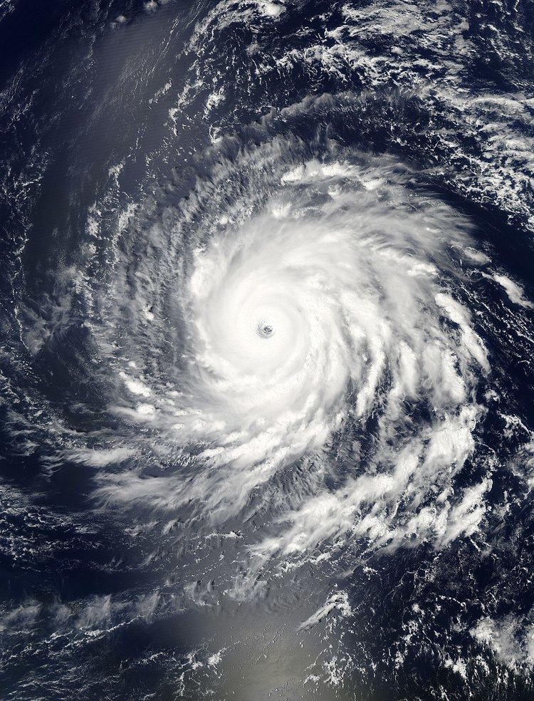
Once classified a hurricane, Igor underwent explosive intensification over the following 24 hours. During this time, satellite observations indicated that the storm's winds increased from 75 mph (120 km/h) to 150 mph (240 km/h) and its barometric pressure decreased by 52 mbar (hPa; 1.53 inHg). Near the end of this phase, forecasters at the NHC predicted that Igor would attain Category 5 status, the highest classification on the Saffir–Simpson Hurricane Wind Scale. With a symmetrical 17 mi (27 km) wide eye, deep convection and spiral banding, Igor maintained Category 4 intensity for nearly five days. Minor fluctuations took place during this period as multiple eyewall replacement cycles occurred. After the first of these cycles, the hurricane is estimated to have reached its peak strength around 0000 UTC on September 15 with winds of 155 mph (250 km/h) and an estimated pressure of 924 mbar (hPa; 27.29 inHg). By this time, Igor began a northwestward track as it executed a prolonged "C-shaped" curve over the Atlantic Ocean.
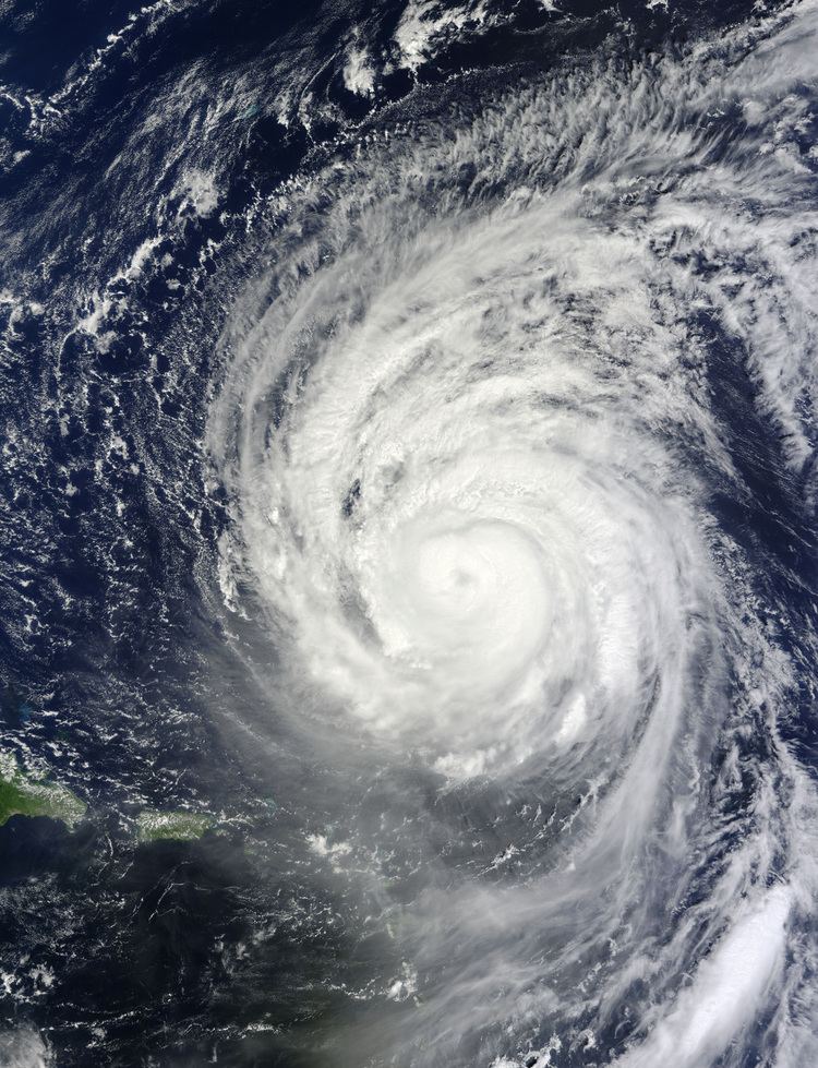
Passing roughly 345 mi (555 km) northeast of the Leeward Islands on September 17, Igor gradually weakened as it experienced increased wind shear and dry air intrusion. Over the following several days, the storm became exceedingly large, with tropical storm-force winds covering an area about 865 mi (1,390 km) wide. Due to an overestimated bias in Igor's intensity, forecasts from the NHC showed that the storm would strike Bermuda as a major hurricane. However, weakening was more marked than anticipated and by the time its center neared the territory on September 20, winds decreased to 75 mph (120 km/h). Igor made its closest approach to Bermuda around 0230 UTC, passing roughly 40 mi (65 km) to the west-northwest.
Once north of Bermuda, Igor began to undergo an extratropical transition as it turned northeastward. Though deep convection was no longer consistently over its center, data from Hurricane Hunters continued to support hurricane intensity. Accelerating along the leading edge of a trough over the Canadian Maritimes, the storm intensified within a baroclinic zone as it neared Newfoundland. The interaction between these two systems allowed the hurricane to strengthen despite moving over decreasing sea surface temperatures. Around 1500 UTC on September 21, Igor made landfall near Cape Race, with winds of 85 mph (140 km/h), slightly higher than several hours earlier. Shortly thereafter, the storm completed its transition into an extratropical cyclone as it became fully embedded within the baroclinic zone. After turning northwestward between Labrador and Greenland, the remnants of Igor were absorbed by another extratropical cyclone on September 23.
Cape Verde and Leeward Islands
Forming near the Cape Verde Islands, Igor prompted the issuance of tropical storm watches for the southern islands on September 8. Though the storm passed relatively close to the region, only minimal effects were recorded. Once the cyclone tracked away from Cape Verde, the watches were discontinued on September 9.
Although several hundred miles from the Leeward Islands, Igor produced large swells averaging 9 to 13 ft (2.7 to 4.0 m) in height, between September 16 and 21. There were also large breaking waves of 15 to 20 ft (4.6 to 6.1 m) or higher. The prolonged period of this event resulted in minor coastal flooding in St. Croix. One person drowned near Carambola Beach Resort after being overcome by large swells. Similar conditions affected Puerto Rico where another person drowned. On several occasions, Luquillo was flooded by the surf, though no damage took place. In nearby Haiti, still reeling from a devastating earthquake in January, officials warned residents of possible relocation from "tent cities" to safer areas. An orange alert was declared across the country, indicating that heavy rains could result in flooding. Portions of the Greater Antilles were affected by large swells and rip currents for several days as Igor approached Bermuda.
United States
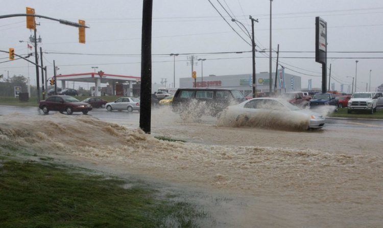
Though Igor's closest approach to the United States only brought it within 600 mi (970 km) of land, its large circulation produced significant swells along the entire East Coast. High surf advisories were issued in Long Island, New York as waves of 6 to 10 ft (1.8 to 3.0 m) affected the area. Rip currents in Florida pulled two people out to sea who were later rescued. One person drowned in Surf City, North Carolina after being overwhelmed by rough surf. Along the New Jersey coastline, waves averaging between 6 and 9 ft (1.8 and 2.7 m) and dangerous rip currents were reported.
Bermuda
Long seen to be within Igor's track, Bermuda was finally placed under a hurricane watch on September 17 as the threat became imminent. Later that day, the watch was upgraded to a warning as hurricane-force winds were anticipated to impact the islands within the following 24 hours. This remained in place for nearly three days while Igor battered Bermuda. Following the passage of hurricane winds, the advisory was changed to a tropical storm warning early on September 20 before being discontinued later that day.
The Bermudian government closed its schools and the Bermuda International Airport on September 20 and 21 in anticipation of Igor. No evacuation plans were put in place, although a local high school was converted into a shelter for residents who felt unsafe in their homes. Residents boarded up structures with plywood in order to protect windows. Tourists on the island wanting to escape the storm left more than a week before Igor's arrival. Additionally, a British Royal Navy vessel and helicopter were stationed offshore to assist with recovery efforts once the storm passed. Prior to Igor's arrival, there were fears that the enormous hurricane would be worse than Hurricane Fabian in 2003 and could "flatten" the territory. These fears resulted from forecasts from the National Hurricane Center which indicated the storm would strike Bermuda as a Category 3 hurricane. However, following post-storm analysis, it was found that the forecast model consensus overestimated the storm's future intensity.
Although effects from Igor were observed in Bermuda for several days, relatively little rain fell, with the highest amount being 3.19 in (81 mm). Winds proved to be the most significant factor; sustained winds reached 91 mph (146 km/h) and gusts peaked at 117 mph (188 km/h) at an unofficial AWOS station on St. David's Lighthouse. Additionally, a storm surge of 1.75 ft (0.53 m) took place in St. George's, this combined with tides to produce a storm tide of over 4 ft (1.22 m). As the storm arrived, the island's airport was shut down earlier than originally planned due to the threat of tornadoes. Against initial fears, Igor left relatively little damage across Bermuda. The most significant impact was from downed trees and powerlines which cut power to 27,500 residents. A few emergency rescues had to be made during the storm but no injuries took place. The causeway-bridge connecting St. George’s Islands to the main island of Bermuda sustained minor damage, leaving one lane closed for several days. Waves over 15 ft (4.6 m) battered the coast, breaking several ships from their moorings and tossing them into rocks. Officials in Bermuda stated that the biggest loss from Igor would be lessened tourism revenue following a mass exodus prior to the hurricane's arrival. Throughout the islands, damage from the storm was less than $500,000.
Canada
On September 20, roughly one day prior to Igor's arrival in Atlantic Canada, the Canadian Hurricane Center (CHC) issued tropical storm watches and warnings for southern Newfoundland and the French territory of Saint Pierre and Miquelon. The following day the CHC issued a hurricane watch for the eastern and northern coasts. Although sustained hurricane-force winds were recorded across parts of the island, warnings were not issued due to stronger-than-expected re-intensification of the storm as it transitioned into an extratropical cyclone. Early on September 22, all advisories were discontinued as Igor moved away from the region. In response to the storm's arrival, schools were closed and several flights were delayed or canceled at St. John's International Airport. Offshore, an oil rig with 110 personnel was mostly evacuated near the coast of Newfoundland on September 19. In comparison to Hurricane Earl two weeks earlier, there was substantially less media attention given to Igor, attributed to the possibility of it going out to sea.
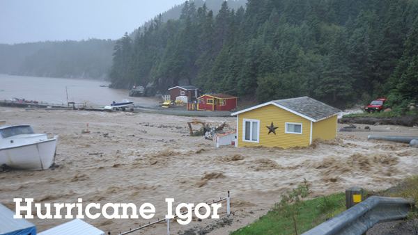
The combination of a stationary front and significant moisture from Hurricane Igor resulted in unprecedented rainfall across parts of eastern Newfoundland, leading to widespread flooding. In Bonavista, more than 10 in (250 mm) was estimated to have fallen between September 20 and 21. In St. Lawrence, a confirmed 9.37 in (238 mm) of rain fell, ranking Igor as the third-wettest tropical cyclone in Canadian history. The widespread nature of heavy rains ranked the storm as a 1-in-100 year event. Similar to the rainfall, winds across eastern Newfoundland were exacerbated by the interaction of the front and Igor. In Cape Pine, near where the center of Igor tracked, sustained winds of 80 mph (130 km/h) and gusts to 107 mph (172 km/h) battered the area. No records for sustained winds or gusts were broken; however, it was noted as a 1-in-50 year event even with powerful winter storms taken into account. Along the coast, Igor produced a storm tide of 3.5 ft (1.1 m). Additionally, offshore waves reached immense heights, measured up to 83.6 ft (25.5 m); one buoy reported a wave of 92 ft (28 m) but data is subject to further analysis to verify it.
The most significant impacts from Igor were attributed to torrential rains, which led to excessive runoff and flash flooding. Several rivers rose to record levels across the Bonavista and Burin Peninsulas where many roads were washed out. Entire bridges, homes and portions of roads were destroyed. In some instances, flood waters were higher than entire homes. In response to the widespread floods, Newfoundland Power Inc. warned residents who still had power by the afternoon of September 21 to turn off their main electrical panel if water enters their basement. Much of St. Bernard's – Jacques Fontaine had to be evacuated by boat during the storm as rising water obstructed all roads in and out of the small town. Portions of Clarenville had to be evacuated under similar circumstances after a state of emergency was declared for the town. Water and sewage lines in Sunnyside broke due to flooding. In Glovertown, downed power lines sparked two fires during the storm, both of which were put out by firefighters without injuries.
Roughly 150 communities were temporarily isolated as all roads leading to them were severely damaged or washed out. Overall damage to roadways was regarded as "colossal" by Tom Hedderson, the minister for emergency preparedness. A 100 ft (30 m) section of the Trans-Canada Highway in Terra Nova National Park was severely eroded, leaving a large ravine behind and disconnecting the main population of Newfoundland from the rest of the island, while a bridge washout on the Burin Peninsula left 20,000 people cut off from the rest of the island. Public infrastructure losses were estimated in excess of $100 million, mainly attributed to roadways. On Random Island, a man was killed when his driveway collapsed from flooding and he was swept out to sea.
In addition to flood damage, hurricane-force winds downed trees and power lines over large areas and many homes were damaged to varying degrees. An estimated 50,000 residences were left without electricity in the region. The small coastal community of South East Bight sustained some of the most significant wind damage where entire fishing sheds were hurled into the air. Along the East Coast hiking trail, an estimated 5,000 trees were downed. In all, losses from the hurricane were placed at $200 million, ranking it as the costliest cyclone in Newfoundland history. In terms of its overall impact, Igor was regarded as the worst hurricane to hit Newfoundland since 1935.
Aftermath
In Igor's wake, a state of emergency was declared for 30 communities in Newfoundland. The mayor of one of the towns affected by Igor, Sam Synard, remarked that "We've never seen such a violent storm before." More than 50 families involved in the storm-induced destruction were relocated to evacuation shelters. Electricity was gradually restored to residents; by six days after the hurricane's passage, a few hundred had yet to regain power.
In light of the widespread damage, 1,000 personnel from the Canadian military were brought in for recovery efforts. The military operation, known as Operation Lama, was to last for the duration of the emergency phase in the immediate aftermath. An initial deployment of 120 soldiers and 40 vehicles arrived on September 25 from the Canadian Forces Base Gagetown in Oromocto, New Brunswick arrived in Newfoundland. Three ships and a fleet of helicopters were called in for the distribution of emergency aid and the military set up temporary bridges while long-term plans for reconstruction were made. Operation Lama also enabled partial repairs of several buildings, and simultaneously, emergency personnel surveyed roughly 500 mi (900 km) of roads in Newfoundland. On September 27, government officials stated that it would take months for cleanup efforts to finish. Ten days after the storm, six towns were still isolated as progress on temporary road reconstruction was being made only slowly. Allocation of military aid continued through October 6, though the number of on-scene personnel began to decrease two days earlier.
Roughly a month after the storm, a benefit concert was held in St. John's. The concert raised about $400,000 (2010 CAD) toward storm relief in one night. In late October, the Government of Newfoundland and Labrador allocated $275,000 in funds for 200 workers who lost their jobs after two fish processing plants were damaged in Marystown and Port Union. However, union leaders claimed that the assistance was insufficient and accounted for just 420 of 600 work hours. Following more than a year of discussions, the plant's parent company, Ocean Choice International, decided to permanently shut down operations on December 2, 2011. Numerous insurance claims, reaching $65 million by early November, were made following Hurricane Igor's landfall Over the course of the recovery phase, several complaints, including concerns lodged by church ministers, that relief funds for victims of the storm were not being distributed fast enough and the overall process was taking too long. Roughly ten months after the hurricane, work on permanent reconstruction of roadways began in several areas across the Burin Peninsula. By January 24, 2011, The Salvation Army received about $1.6 million worth of donations for residents affected by Hurricane Igor, roughly half of which had been distributed at that point. An additional $200,000 had been pledged by donors.
In June 2011, a federal document detailing the actions made by province officials was released to be public and incited further outcry from residents affected by the storm. The main complaint raised was related to the delay in accepting federal aid despite the severity of the damage. In an email sent on September 21, 2010, Denys Doiron, the nation's Emergency Preparedness and Response Officer, relayed that local emergency services reported Igor to be the worst disaster they have had to deal with. Doiron also stated that no requests for federal aid were made.
Nearly a year after the passage of Igor, a weather buoy from St. John's was spotted near the Shetland Islands north of Scotland on September 12, 2011. In early October, Newfoundland was again struck by a tropical cyclone – Hurricane Ophelia. Though a weaker storm, Ophelia caused more damage than expected as it destroyed infrastructure repaired in the wake of Igor. The mayor of Marystown criticized government officials for not increasing the size of repairs, especially to culverts, to account for flooding.
Retirement
Due to the extensive damage in Newfoundland, the name Igor was retired in the spring of 2011 by request of the Meteorological Service of Canada, and will never again be used for an Atlantic hurricane. In Canada's report to the World Meteorological Organization, it was stated to be a storm without parallel in the island's history. This was only the second time that the Meteorological Service of Canada had requested that a hurricane name be retired (the first was Hurricane Juan in 2003). The hurricane is also considered a probable benchmark for future cyclones in the region, having illustrated to residents that they are not immune from hurricanes and their impacts. The name was replaced by Ian and was first used during the 2016 season.