
Formed August 31, 2007 Fatalities 130 direct, 3 indirect | Dissipated September 7, 2007 Highest winds 282 km/h | |
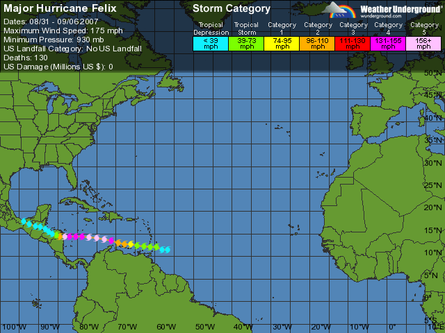 | ||
Lowest pressure 929 mbar (hPa); 27.43 inHg Damage $720 million (2007 USD) Areas affected Trinidad and Tobago, Windward Islands, Venezuela, Leeward Antilles, Colombia, Costa Rica, Nicaragua, Honduras, El Salvador, Belize, Guatemala, Mexico Date 31 August 2007 – 5 September 2007 Similar Hurricane Dean, Hurricane Noel, Hurricane Mitch, Hurricane Matthew, Hurricane Wilma | ||
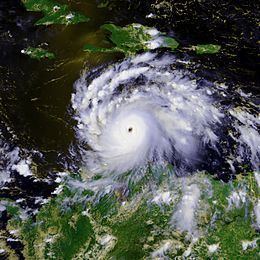
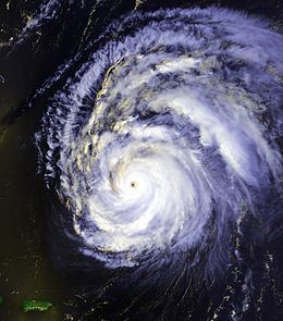
Sandy bay bilwi nicaragua hurricane felix 2007
Hurricane Felix was the southernmost landfalling Category 5 hurricane in the Atlantic; surpassing Hurricane Edith of 1971. It was the sixth named storm, second hurricane, and second Category 5 hurricane of the 2007 Atlantic hurricane season. Felix formed from a tropical wave on August 31, passing through the southern Windward Islands on September 1 before strengthening to attain hurricane status. A day later it rapidly strengthened into a major hurricane, and early on September 3 it was upgraded to Category 5 status; by 2100 UTC, the hurricane was downgraded to Category 4 status, but was upgraded to a Category 5 hurricane for the second and final time by the morning of September 4.
Contents
- Sandy bay bilwi nicaragua hurricane felix 2007
- Hurricane felix 2007 video 1 credit noaa aoc
- Meteorological history
- Preparations
- Caribbean Islands
- Central America
- Aftermath
- Retirement
- References
On September 4, Felix made landfall just south of the border between Nicaragua and Honduras, in the Mosquito Coast region, as a Category 5 hurricane with 160 mph (260 km/h) winds. Hurricane Felix struck Nicaragua on the same day as Hurricane Henriette struck the Baja California Peninsula in the eastern Pacific Ocean, which marked the second recorded occurrence that a North Atlantic hurricane and a Pacific hurricane made landfall on the same day; the previous occurrence was on August 23, 1992, when Hurricane Andrew hit the Bahamas on the same day Hurricane Lester hit Mexico's Baja California Peninsula. At least 133 deaths are attributed to Felix.
Hurricane felix 2007 video 1 credit noaa aoc
Meteorological history
A tropical wave moved off the coast of Africa on August 24, tracking westward at approximately 14 mph (23 km/h) with no associated deep convection and a weak low-level inverted-V curvature. Initially difficult to locate on satellites, the wave axis tracked through a moist environment and developed an area of scattered thunderstorms. By August 25 visible satellite imagery indicated broad cyclonic turning just north of the Intertropical Convergence Zone. The wave continued to develop moderate to strong convection, and on August 27 a 1012 mbar (hPa; 29.88 inHg) low pressure area developed about 830 mi (1,340 km) west-southwest of Praia, Cape Verde. For the next several days the system failed to organize significantly; however, on August 30 the wave became better defined with more representation of the cyclonic turning into the low. Convection increased early the next day, and a Hurricane Hunters flight into the system reported the presence of a closed low-level circulation; accordingly, the National Hurricane Center initiated advisories on Tropical Depression Six at 2100 UTC on August 31 while it was located about 180 mi (295 km) east-southeast of the southern Windward Islands.
Upon becoming a tropical cyclone, the depression was located to the south of a strong ridge, resulting in a west-northwest motion. The system maintained curved rainbands with expanding outflow, and with light wind shear and warm water temperatures the environment favored further development. Its deep convection consolidated very near the center, and shortly after passing over the island of Grenada the depression intensified into Tropical Storm Felix early at around 0900 UTC on September 1. Felix quickly strengthened as it developed a small inner core of convection with tightly-wound bands around the center, and by late on September 1 an eye feature was observed on satellite imagery. Based on reports from reconnaissance aircraft, the National Hurricane Center estimated that Felix attained hurricane status by early on September 2 while located about 155 mi (250 km) east-northeast of Bonaire.
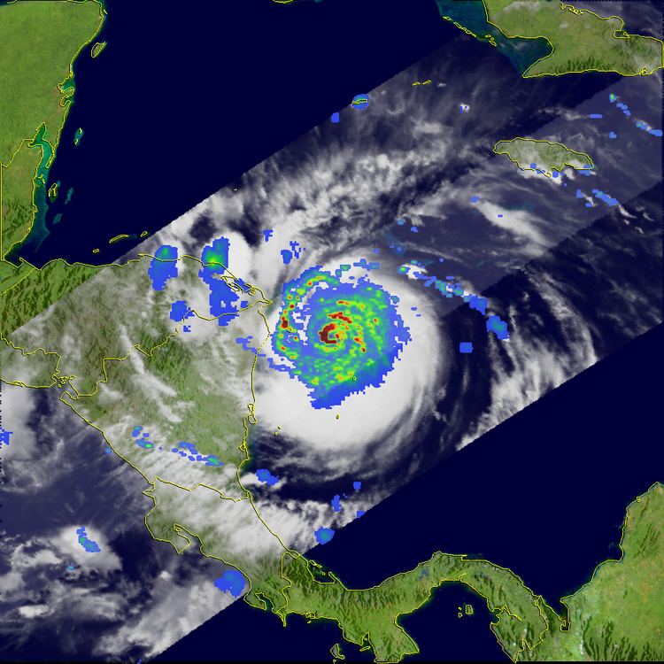
Tracking through an area of extremely low wind shear and increasingly high oceanic heat content, Hurricane Felix quickly developed a well-defined eye, a symmetric cloud structure, and strong upper-level outflow. Felix was upgraded to major hurricane status at around 1800 UTC on September 2 while located about 490 mi (790 km) southeast of Kingston, Jamaica. Rapid strengthening continued, and later that day the hurricane attained Category 4 status on the Saffir-Simpson Hurricane Scale with the pressure dropping to 957 mbar (hPa; 28.26 inHg); this corresponded to a falling rate of 3.4 mbar (hPa; 0.1 inHg) per hour, which the National Hurricane Center described as "one of the more rapid deepening rates we have observed." A Hurricane Hunters flight reported a stadium effect in the eye, and also reported the eye diameter shrank to 14 mi (22 km). A subsequent Hurricane Hunters flight experienced flight level winds of 175 mph (280 km/h), with peak surface winds of 163 mph (263 km/h) reported in the southwest quadrant of the eyewall; surface winds of 189 mph (306 km/h) were found in its northeastern quadrant, although the National Hurricane Center reported the peak reading could have been contaminated due to graupel in the clouds. Based on the observations, it is estimated Felix attained winds of 175 mph (280 km/h) by 0000 UTC on September 3 while located about 390 mi (625 km) southeast of Kingston, Jamaica, making Felix a Category 5 hurricane on the Saffir-Simpson Hurricane Scale. While investigating the hurricane, Hurricane Hunters encountered extreme turbulence and potentially dangerous graupel, which forced the flight to abort the mission.
Continuing quickly westward, the diameter of the eye decreased to 12 mi (19 km), and the National Hurricane Center estimates the hurricane attained a minimum central pressure of 929 mbar (hPa; 27.43 inHg) about seven hours after it reached Category 5 status. Initially, Felix was predicted to track west-northwestward, striking Belize before crossing the Yucatán Peninsula; however, its path remained nearly due westward. Subsequently, cloud tops near the center started to warm as the eye became less distinct, and by 1800 UTC on September 3, Felix weakened to Category 4 status with winds of 145 mph (235 km/h). On September 4, Felix had completed an eyewall replacement cycle and began strengthening again during the day. Felix was upgraded to a Category 5 for the second time at 1040 UTC, and made landfall in extreme north-eastern Nicaragua shortly thereafter with winds of 160 mph (260 km/h). By nine hours after moving ashore, the system maintained a well-organized cloud pattern and intense rainbands, although the winds rapidly decreased; early on September 5 Felix weakened to a tropical storm as its upper-level circulation became detached from the low-level portion. The system deteriorated to a tropical depression as it crossed into southern Honduras, and at 0900 UTC the National Hurricane Center issued the last advisory on Felix as it began degenerating into a broad low pressure area. The remnants of Felix tracked west-northwestward over other portions of Latin America, and eventually dissipated over the Mexican state of Tabasco on September 7.
Preparations
Upon Felix's becoming a tropical cyclone, a tropical storm warning was issued for Saint Vincent and the Grenadines, Tobago, and Grenada and its dependencies; a tropical storm watch was also issued for the northeastern Venezuela coast from Cumaná to Pedernales, including Isla Margarita, as well as the ABC islands. The National Emergency Management Agency of Tobago was fully activated, with 79 shelters opened on the island. Coinciding with the upgrade of Felix to tropical storm status, the watch for the ABC islands was upgraded to a tropical storm warning. A hurricane watch was added to the islands early on September 2, where several tourists attempted to leave by plane prior to the arrival of the storm. Early on September 2, the government of Jamaica issued a tropical storm watch for the island, which was canceled as the hurricane passed far to its south. Later on September 2, a tropical storm watch was issued for Grand Cayman, and the next day a tropical storm warning was put in place on Providencia Island. A hurricane watch was issued for the Caribbean coast of Guatemala and the entire coastline of Belize at 1200 UTC on September 3.
At 0300 UTC on September 3, the government of Honduras issued a hurricane watch from Limón to the Honduras/Nicaragua border, which was upgraded to a hurricane warning six hours later. At the same time, a hurricane watch was extended westward to the Honduras/Guatemala border, and early on September 4 a tropical storm warning was put in place for the same region. Officials ordered evacuations for citizens in low-lying areas near the coastline; by midday on September 3, around 300 tourists evacuated from the Bay Islands department, with an additional 400 preparing to leave by plane; approximately 2,000 people were evacuated from coastal areas. By the time the hurricane made landfall, about 20,000 people in Honduras left for safer areas.
At 1500 UTC on September 3, about 21 hours before its final landfall, the government of Nicaragua issued a hurricane warning from Puerto Cabezas northward to the national border. About 12 hours before landfall, a tropical storm warning was issued from Puerto Cabezas southward to Prinzapolka. Prior to the arrival of the hurricane, officials sent about 140,000 lbs (63,000 kg) of meals and emergency supplies to near the landfall location.
Caribbean Islands
At around 1200 UTC on September 1 a wind gust of 46 mph (74 km/h) was recorded on Barbados, and around the same time a gust of 44 mph (71 km/h) was observed in Saint Vincent. The storm produced heavy rainfall across the Windward Islands. On Trinidad, heavy precipitation caused mudslides and overflown rivers which destroyed some bridges; moderate winds damaged several buildings on the island. Damage on neighboring Tobago was concentrated on its northern portion, where several mudslides resulted from the rainfall; monetary damage on Tobago was estimated at $250,000 (2007 TTD; $40,000 2007 USD, $46.2 thousand 2017 USD). Felix produced gusty winds on Grenada, which downed several power lines and destroyed the roofs of two houses; rough waves also broke several vessels from their anchors. In St. Lucia, winds from the storm damaged the roof of a store in Castries, which collapsed and destroyed 12 vehicles.
In the ABC islands, the hurricane resulted in gusty winds and heavy rainfall. However, little damage was reported in Bonaire; the precipitation left several homes submerged under water in Curaçao. In Aruba, the winds damaged one house and briefly left a northern town without power. Hurricane Felix produced strong winds and 10 ft (3 m) waves along the north coast of Venezuela, which left one person missing in Puerto Cabello.
Central America
Early reports suggest severe damage in Honduras and Nicaragua after Felix made landfall as a Category 5 hurricane. In Puerto Cabezas, nearly every structure sustained at least roof damage, and many buildings were destroyed. Along the Mosquito Coast, flooding and mudslides were reported, destroying many houses and blocking highways. The government of Nicaragua declared the northern Caribbean coast a disaster area. The Miskito Cays, located about 43 mi (69 km) from Bilwi on the northeast coast of Nicaragua, was among the strongest hit areas. Hurricane Felix had not yet made landfall but reached maximum force when it passed over the Miskito Cays. The winds of the hurricane, with speeds of up to 160 mph (260 km/h), destroyed the Cays completely. Pillars that previously formed the base of the houses were the only remains on the Cays.
At least 133 people were reported dead. At least 130 of them were in Nicaragua. While few details have been disclosed, they include at least 25 dead Miskito fishermen swept away, a drowning death on a boat, impact from a fallen tree and at least one indirect death caused by medical complications after birth. There were three deaths reported in Honduras, one of which was caused by a motor vehicle accident caused by heavy rain and landslides, and two caused by flooding in the capital city of Tegucigalpa. However, hundreds of others were missing (mostly at sea), and communication was difficult to impossible in many areas. Some survivors were also found on the Mosquito Coast who were initially reported missing.
According to official information, at least 40,000 people were affected and 9,000 houses destroyed, most of them in the Nicaraguan city of Bilwi (Puerto Cabezas), where a "State of Disaster" was decreed by the government. A total lack of supplies and services were also reported in the area. The response was almost immediate. Help from Venezuela, Cuba, the United States, and Honduras was received, and a lot of organizations, such as the Nicaraguan Red Cross, the media and universities organized collections all over the country. Nicaraguan President Daniel Ortega visited Bilwi on the day after the catastrophe and promised the reconstruction of houses to the people affected. Damage in Nicaragua totaled 13.4 billion (2007 NIO; $716.3 million 2007 USD, $827 million 2017 USD).
Inland flooding was also reported in Honduras, particularly near Tegucigalpa and in the northwestern regions where the Ulua River and the Chamelecon River overflowed into an agricultural area. Coastal flooding also damages the town of Izabal in Guatemala where 850 people were evacuated. Crop damage in Honduras amounted to L68.28 million (2007 HNL; $3.64 million 2007 USD, $4.2 million 2017 USD).
Aftermath
After Felix, over 160,000 people were suffering as many communities were stranded due to the storm. An appeal was given out by the United Nations for over $48 million (2007 USD, $55.4 million 2017 USD) in emergency aid to the hard-hit areas, particularly in Nicaragua. The appeal United States federal government delivered over $1.17 million (2007 USD, $1.35 million 2017 USD) in assistance, and the European Union responded with a donation of €1 million euros ($1.36 million 2007 USD, $1.57 million 2017 USD). The United States Agency for International Development (USAID) and the Office of Foreign Disaster Assistance (OFDA) airlifted 120 rolls of plastic sheeting to the severely affected areas, which was used to repair the damaged roofs of health clinics and schools. USAID and OFDA also distributed 12,000 ten-liter water containers to Puerto Cabezas. Emergency relief supplies from both USAID and OFDA totaled to $94,190 (2007 USD, $109 thousand 2017 USD). In the aftermath of both Hurricane Dean and Felix, combined, USAID and OFDA donated $25,000 (2007 USD, $28.9 thousand 2017 USD) in aid to Honduras, and $1.2 million (2007 USD, $1.39 million 2017 USD) to Nicaragua. In addition, United States Department of Defense (USDOD) gave $1.5 million (2007 USD, $1.73 million 2017 USD) in humanitarian assistance to Nicaragua. In collaboration with USAID and OFDA, the USDOD delivered near 27.55 tons (25 metric tons) of food from the United Nation's World Food Program to the North Caribbean Coast Autonomous Region, Nicaragua.
Retirement
Due to the extensive damage and high death toll from Felix in Nicaragua, the name was officially retired on May 13, 2008 by the World Meteorological Organization during its annual meeting in Orlando, Florida, and will never be used again for any future Atlantic hurricanes. It was replaced by Fernand on List V of the Atlantic hurricane naming lists, which was used in the 2013 Atlantic hurricane season.