
Formed July 24, 1996 Highest winds 209 km/h | Dissipated August 6, 1996 | |
 | ||
Lowest pressure 946 mbar (hPa); 27.94 inHg Fatalities 113 deaths, 29 missing (all as Cesar) Damage $203 million (1996 USD) Areas affected Windward Islands, Trinidad and Tobago, Leeward Antilles, Venezuela, Colombia (as Cesar) Mexico, Socorro Island (as Douglas) Central America (as both) Date 24 July 1996 – 6 August 1996 Similar Hurricane Joan–Miriam, Hurricane Hortense, Hurricane Diana, Hurricane Fifi–Orlene, Tropical Storm Arthur | ||
Hurricane Cesar–Douglas was the most recent tropical cyclone to survive the crossover from the Atlantic to east Pacific basin until Hurricane Otto in 2016, and was also the last tropical cyclone to receive two names upon doing so. Cesar was the third named storm and second hurricane of the 1996 Atlantic hurricane season. The system formed in the southern Caribbean Sea and affected several countries in South America before crossing Nicaragua and entering the eastern Pacific where it was renamed Douglas. The storm killed 113 people in Central and South America and left 29 others missing, mainly due to flooding and mudslides.
Contents
Meteorological history
The origins of Hurricane Cesar were from a tropical wave and an elongated area of low pressure that emerged into the Atlantic from the west coast of Africa on July 17. For several days, the wave moved westward without any organization, although an anticyclone aloft provided conditions favorable for development. On July 22, convection, or thunderstorms, increased along the wave as it approached the southern Windward Islands. Surface pressure steadily dropped as the system moved through the Lesser Antilles, and a circulation began developing near Trinidad and Tobago. Based on surface and satellite data, it is estimated the system developed into Tropical Depression Three at 1800 UTC on July 24 near Isla Margarita, off the north coast of Venezuela. Operationally, the National Hurricane Center (NHC) did not consider it as a tropical depression until 18 hours later.
With an unusually strong high pressure area located over The Bahamas, the tropical depression moved westward through the southern Caribbean near the northern coast of South America. Around 1200 UTC on July 25, it struck the island of Curaçao, which reported sustained winds of 45 mph (75 km/h). The observation indicated the depression attained tropical storm status, although operationally the depression wasn't upgraded until the next day, at which point the NHC named the storm Cesar. After crossing Curaçao, the storm moved near or over Guajira Peninsula in extreme northern Colombia. Its proximity to South America prevented significant strengthening, until late on July 26 when the storm reached the open waters of the southwest Caribbean Sea.
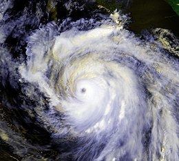
On July 27, Cesar attained hurricane status about halfway between Nicaragua and Colombia. Later that day, the hurricane passed over San Andrés island, which is part of a small Colombian archipelago off the east coast of Nicaragua. As Cesar approached Central America, a 17 mile (19 km) eye formed, surrounded by deep convection in the form of an eyewall. At about 0400 UTC on July 28, Hurricane Cesar made landfall just north of Bluefields, Nicaragua with winds of 75 mph (140 km/h). It moved quickly west-northward through the country, weakening to tropical storm status and emerging into the eastern Pacific Ocean by July 29. This made Cesar the most recent tropical cyclone to traverse from the Atlantic to east Pacific basin until Otto achieved the same feat in 2016. In addition, following the dissipation of Cesar–Douglas there was a policy change which determined that future storms would retain their original name upon crossing into another basin. Upon reaching the Pacific, the system was renamed Tropical Depression Seven-E, but in a post-analysis it was determined the cyclone maintained tropical storm status while crossing Central America. Once its status as a tropical storm was confirmed, it was renamed Tropical Storm Douglas. At the time, the agreement through the World Meteorological Organization was for storms to be renamed if they cross from the Atlantic to the Pacific.
As the storm moved westward, it quickly intensified, with an eye-like feature developing by 0900 UTC on July 29. Shortly thereafter, Douglas attained hurricane status about 115 mi (185 km) southwest of the Guatemala/Mexico border. Around that time, tropical cyclone prediction models anticipated two scenarios for the future of Douglas; one was a northwest track to make landfall near Acapulco, and the other was a continued west-northwest track while remaining offshore. Hurricane Douglas ultimately took the latter track. By late on July 29, the eye of the hurricane was well-defined on Mexican radar, and with favorable upper-level outflow, warm sea surface temperatures, and a climatologically favorable region for intense hurricanes, the NHC forecast Douglas to strengthen to winds of 115 mph (185 km/h). The next day, its structure became atypical of a strengthening hurricane, and the eye was briefly not seen on satellite imagery.
On July 31, Douglas became much better organized as it turned more west-northwestward, and it attained major hurricane status, or a Category 3 on the Saffir–Simpson scale, about 205 miles (330 km) southwest of Manzanillo. By early on August 1, Douglas reached peak winds of 130 mph (215 km/h), a Category 4 on the Saffir–Simpson scale. Later that day, the hurricane attained its lowest pressure of 946 mbar about 275 miles (440 km) south of the southern tip of the Baja California peninsula. Douglas maintained peak intensity for 36 hours, until August 2 when the eye became less-organized as the overall convection began to weaken. Weakening continued due to cooler waters as Douglas turned to the west, and on August 3 the hurricane deteriorated to tropical storm status. As a tropical storm, there was minimal deep convection, although the center remained very well-defined. On August 5, Douglas weakened to tropical depression status, and by the next day could no longer be classified as a tropical cyclone. The remnant circulation continued westward for several days.
Preparations
Prior to Cesar's arrival in Venezuela, a tropical storm warning was issued for areas west of La Vela de Coro to the border with Colombia; the warning was discontinued later that day. The government of Colombia issued a tropical storm warning on July 25 from the border with Venezuela to Barranquilla as well as the islands of Aruba and Curaçao. These warnings were discontinued later that day after the storm's passage.
As Cesar approached Central America, hurricane warnings were posted in Nicaragua 31 hours before landfall, leaving ample time to prepare for the hurricane. With Hurricane Joan occurring only 8 years prior, 10,724 people were evacuated before and during the hurricane to take refuge at special camps.
On July 29, shortly after Cesar emerged into the Pacific Ocean and was reclassified Tropical Depression Seven-E, the government of Mexico issued a tropical storm watch from Puerto Madero to Acapulco. About 12 hours later, after the depression intensified into Tropical Storm Douglas, the Mexican government canceled the watch and issued a new tropical storm warning from Salina Cruz to Acapulco; this was due to the large extent of tropical storm force winds associated with Douglas and its proximity to the south coast of Mexico. Another tropical storm watch was briefly issued on July 30 from Acapulco to Manzanillo.
Impact
Hurricane Cesar was a moisture-laden tropical cyclone that dropped heavy rains along its path through the southern Caribbean Sea and Central America. Damage was moderate to extreme due to mudslides and flooding, and at least 113 people were killed.
Lesser Antilles and South America
The precursor tropical wave to Cesar produced rains and gusty winds through a large portion of the Lesser Antilles. In Venezuela, heavy rains from the storm triggered flooding and landslides that killed at least five people. In the capital city of Caracas, 45 people were left homeless as a result of the storm. Although the storm passed directly over the region, the ABC islands off the coast of Colombia and Venezuela received little rainfall, peaking at 0.15 in (3.8 mm) on Curaçao. Peak gusts were also measured at 60 mph (95 km/h) on the island. The winds caused minor damage to roofs and trees across all three islands, as well as rough surf that drowned one person in Curaçao.
As a tropical storm, Cesar struck the northern coastline of Colombia, bringing heavy rains and gusty winds. At least three people were killed in storm related incidents, two of which occurred when an avalanche buried a house in Pueblo Bello in the northern part of the country. Cesar brought torrential rains to the Archipelago of San Andrés, Providencia and Santa Catalina offshore eastern Nicaragua. Eleven people were killed across the archipelago, including eight children who died in a landslide. Across the islands, 60 homes lost their roofs and numerous trees were felled due to high winds. The local governor stated that losses from Cesar reached 800 million COP ($440,00 USD).
Nicaragua
Torrential rainfall was the immediate effect of Cesar, peaking at 10.7 inches (271 mm) at Bluefields, Nicaragua with many other locations reporting over 6 inches (150 mm). The intense precipitation led to widespread mudslides and overflown rivers across the mountainous country. The most affected region was Lake Managua where the water level was approaching dangerous levels. The storm wrought extensive damage throughout the country, leaving roughly $50.5 million in damage behind. Large portions of the country's crops were affected, resulting in a food shortage following the hurricane. According to Nicaraguan officials, more than 2,500 homes, 39 bridges and 40 km (25 mi) of road were destroyed by Cesar. In all, the storm killed 42 people and left an estimated 100,000 homeless.
Costa Rica
Like Nicaragua, Costa Rica received heavy rainfall from Cesar, leading to mudslides and widespread flooding. River flooding damaged 51 houses and washed away 213 more; 72 bridges were also destroyed. The road network was significantly damaged. Costa Rica requested international aid subsequent to the storm. Across the country, at least 39 people were killed and damage amounted to $151 million. Additionally, 29 people were listed as missing.
El Salvador
As Cesar continued westward, it produced heavy flooding and mudslides in western El Salvador, killing 9 in the community of José Cecilio del Valle. Four others drowned in other parts of the country.
Mexico
Hurricane Douglas brought up to 6 inches (150 mm) of rain on the south coast of Mexico and resulted in a 4 foot (1.2 m) storm surge, but no deaths were reported.
Aftermath
The name Cesar was retired in spring of 1997, and will not be used again in the Atlantic basin. It was replaced with Cristobal in the 2002 season.
Because it caused no effects on land, the name Douglas was not retired. It was reused in the 2002, 2008, and the 2014 seasons.