
Existed: 1935 – present Constructed 1935 | Length 985.2 km | |
 | ||
Counties | ||
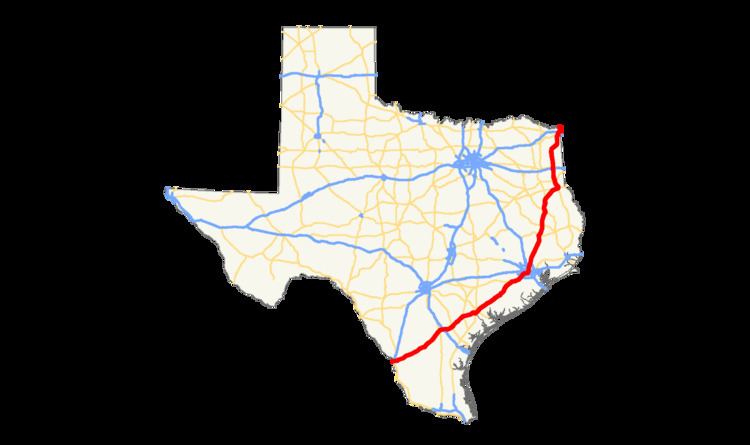
U.S. Highway 59 (US 59) in the U.S. state of Texas is named the Lloyd Bentsen Highway, after Lloyd Bentsen, former U.S. senator from Texas. In northern Houston, US 59, co-signed with Interstate 69 (I-69), is the Eastex Freeway (from Downtown Houston to the Liberty County/Montgomery County line). To the south, which is also co-signed with I-69, it is the Southwest Freeway (from Rosenberg to Downtown Houston). The stretch of the Southwest Freeway just west of The Loop was formerly one of the busiest freeways in North America, with a peak AADT of 371,000 in 1998.
Contents
- History
- Laredo to Interstate 37
- Interstate 37 to Houston
- Houston to Marshall
- Marshall to Texarkana
- Future
- References
US 59 (overlapped by US 71) actually straddles the border between Texas and Arkansas north of I-30 near Texarkana, with the east side of the highway on the Arkansas side and the west side of the highway on the Texas side. In the past, both highways remained on the border past I-30 as State Line Avenue to downtown Texarkana; today, only US 71 does so. Nearly 90 percent of this route is designated to become part of I-69 in the future. Currently 75-mile-per-hour (121 km/h) speed limits are allowed on US 59 in Duval County and portions of northern Polk County.
The total length of the southernmost segment of US 59 that passes through Texas and terminates at the Mexico–US border is 615 miles (990 km).
History
The US 96 designation was originally applied in 1926 from Rosenberg, Texas, near Houston, to Pharr in the Rio Grande valley. This diagonal route, south of U.S. 90, did not violate the convention of even numbers for east–west routes. The highway's east–west nature was boosted in 1934 when US 96 was rerouted from Alice to Laredo.
Laredo to Interstate 37
US 59 begins at the Mexico–US border with Loop 20 on the World Trade International Bridge over the Rio Grande in Laredo. The portion of US 59 that is co-signed with Loop 20 is also named the Bob Bullock Loop. At under 2 miles, the two highways run together concurrent with I-69W from the Mexico–US border until I-35 in Laredo, where I-69W temporarily ends. US 59 and Loop 20 continue to run together until just south of Lake Casa Blanca, where Loop 20 heads south to Mangana-Hein Road and US 59 heads towards Freer; traveling in a mostly northeast direction. In Duval County, the speed limit on US 59 is 75 miles per hour, the highest speed limit on the highway. US 59 shares a short congruency with SH 44 in and around Freer. From Freer, US 59 passes through the southeastern part of McMullen County, but does not intersect any highways. The highway continues northeast, intersecting US 281 in George West, before intersecting I-37 about 55 miles north of Corpus Christi. Between Laredo and Interstate 37, US 59 passes through many rural areas and ranching sites.
Interstate 37 to Houston
From I-37, US 59 heads northeast passing through Beeville. US 59 bypasses Victoria to the south, and becomes a divided highway, and has a series of interchanges, until it becomes a freeway south of Houston in Rosenberg and resumes the designation of I-69. Between Houston and Victoria, US 59 passes through Edna, Ganado, El Campo, and Wharton. US 59 intersects many major Texas highways in Houston, including I-10 (which goes to San Antonio and Beaumont) and I-45 (which goes to Dallas and Galveston).
Houston to Marshall
Leaving Houston, US 59 intersects Beltway 8 again on the northside of town, passing by Bush Intercontinental Airport and heads into Humble. Between Houston and Livingston, most of US 59 is a limited-access freeway but the I-69 designation ends at the Montgomery-Liberty county line. US 59 passes through or bypasses the towns of Cleveland and Livingston. 46 miles north of Livingston, US 59 bypasses Lufkin, where it overlaps US 69. 10 miles north of Lufkin, US 59 bypasses Nacogdoches and heads in an almost entirely east-west direction. Drivers wishing to stay on US 59 must turn left in Tenaha, where the highway intersects US 96 and ends its overlap with US 84. US 59 passes through Carthage before intersecting I-20 south of Marshall.
Marshall to Texarkana
US 59 intersects US 80 in Marshall, where US 59 is known as East End Boulevard (due to the fact the highway runs on the east side of town, near the city limits). US 59 passes through Jefferson, 15 miles west of Caddo Lake. US 59 passes through the towns of Linden and Atlanta before arriving in Bowie County. US 59 intersects SH 93 south of Texarkana, the old highway through the city. Shortly after, I-369 designation with US 59 when the freeway intersects Spur 151, where US 59 becomes a freeway on the westside of the city. Before US 59 intersects I-30, and overlaps I-30 until exit 223B, at the state line, I-369 designation ends. After leaving I-30, US 59 joins US 71, where both highways run on the state line between Texas and Arkansas, where both highways continue north towards DeQueen, Arkansas.
Future
US 59 is in the process of being upgraded between Laredo & Victoria, to become I-69W, Between Victoria & Tenaha, as I-69, and Tenaha & Texarkana, I-369. Segments of I-69 are currently designated. I-69W runs between Mexico and I-35. I-69 runs through the Houston Metro, and a segment of I-369 exists on the west side of Texarkana. The entire I-69 project in Texas does not have a completion date.