
Length 120.5 km | Constructed 5 December 2011 | |
 | ||
Existed: December 5, 2011 (2011-12-05) – present | ||
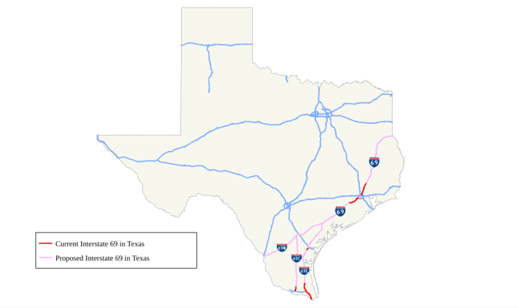
Interstate 69 (I-69) in the U.S. state of Texas is an extension of that existing Interstate Highway that will pass through the eastern part of the state and along the Gulf Coast to Victoria, where it will split into multiple segments with I-69E terminating in Brownsville, I-69C terminating in Pharr, and I-69W terminating in Laredo.
Contents
The first segment of I-69 in Texas was opened in 2011 near Corpus Christi. The American Association of State Highway and Transportation Officials (AASHTO) approved an additional 53 miles (85 km) of US 77 from Brownsville to Raymondville for designation as I-69, which was to be signed as I-69E upon concurrence from the Federal Highway Administration (FHWA). FHWA approval for this segment was announced on May 29, 2013. By March 2015, a 74.9 mile section of US-59 had been completed and designated as I-69 through the Houston Metropolitan Area.
Route description
The congressionally designated I-69 corridor begins at the Mexican border with 3 auxiliary routes:
I-69W and I-69E will merge just south of Victoria, Texas, where mainline I-69 will follow US 59 northeast to Fort Bend County. In the Houston area, I-69 follows US 59 (Southwest Freeway) from Fort Bend County to the west loop of I-610. I-69 then follows US 59 (Eastex Freeway) from the north loop of I-610 to the Liberty-Montgomery county line. The segment of US 59 inside Loop I-610, through downtown Houston, was approved for designation as I-69 by the FHWA on March 9, 2015 and approved for signage as I-69 by the Texas Transportation Commission on March 25, 2015.
I-69 will follow US 59 to the north, serving Cleveland, Shepherd, Livingston, Lufkin, Nacogdoches, and Tenaha. At Tenaha, I-69 will head into Louisiana along the US 84 corridor. The segment of US 59 from Tenaha to Texarkana will be signed as I-369.
Since the first section of US 77 between Corpus Christi and Robstown was signed as I-69, it implied that the I-69 mainline would follow the coastal (US 77) route from Victoria to Brownsville. This also implied that the branch along US 59 from Victoria to Laredo and the branch along US 281 from George West to Pharr would be signed as either three-digit spurs of I-69 (I-x69) or as separate two-digit Interstate Highways. While federal legislation designating the south Texas branches as I-69 suggested that these routes may be designated as "I-69E" (east, following US 77), "I-69C" (central, following US 281), and "I-69W" (west, following US 59), the American Association of State Highway and Transportation Officials Special Committee on Route Numbering rejected the Texas Department of Transportation's request for these three designations along the proposed I-69 branches, citing that AASHTO policy no longer allows Interstate Highways to be signed as suffixed routes. Stating that the I-69E, I-69C, and I-69W designations for the three I-69 branches south of Victoria were written into federal law, the initial denial of TxDOT's applications were subsequently overturned by the AASHTO Standing Committee on Highways, and the approval for the I-69E, I-69C, and I-69W branch designations were confirmed by the AASHTO Board of Directors, pending concurrence from the Federal Highway Administration during the AASHTO Spring Meeting on May 7, 2013. During this same meeting, the section of US 83 between Harlingen and Penitas was conditionally approved to be designated as I-2, with FHWA concurrence. The US 83 freeway in south Texas was widely anticipated to receive an I-x69 designation instead of I-2. In any case, Texas is proceeding in the same fashion as Indiana, conducting environmental studies for its portion of I-69 in a two-tier process. The mainline route through Texas will be approximately 500 miles (800 km). On June 11, 2008, TxDOT announced they planned to limit further study of I-69 to existing highway corridors (US 59, US 77, US 84, US 281, and SH 44) outside transition zones in the lower Rio Grande Valley, Laredo, Houston, and Texarkana.
Texas originally sought a public-private partnership to construct much of the route through Texas as a privately operated toll road under the failed Trans-Texas Corridor project. However, on June 26, 2008, TxDOT announced that they had approved a proposal by Zachry American and ACS Infrastructure to develop the I-69 corridor in Texas, beginning with upgrades to the US 77 corridor between Brownsville and I-37; the Zachry/ACS plan calls for the majority of the freeway to be toll-free; the only two tolled sections would be bypasses of Riviera and Driscoll.
Original plans for the route included a potential overlap with the "TTC-35" corridor component as well, but the preferred alternative for that component follows I-35 south of San Antonio instead of entering the lower Rio Grande Valley.
History
By July 2011, Texas has been proceeding with upgrading rural sections of US 59, US 77, and US 281 to interstate standards by replacing intersections with interchanges, and converting two-lane stretches to four lanes by adding a second carriageway to the existing roadway.
A stated goal of TxDOT's I-69 initiative is that "existing suitable freeway sections of the proposed system be designated as I-69 as soon as possible". A bill was introduced and passed by the House of Representatives that allows interstate quality sections of US 59, US 77, and US 281 to be signed as I-69 regardless of whether or not they connected to other Interstate Highways.
Meanwhile, TxDOT has submitted an application to the Federal Highway Administration (FHWA) and the American Association of State Highway and Transportation Officials (AASHTO) to designate 75 miles (121 km) of US 59 in the Houston area and eight miles (13 km) of US 77 near Corpus Christi as I-69, as these sections are already built to Interstate standards and connect to other Interstate Highways. In August 2011, TxDOT received approval from FHWA for a six-mile (9.7 km) segment of US 77 between I-37 and SH 44 near Corpus Christi, and was approved by AASHTO in October 2011. Officials held a ceremony on December 5, 2011, to unveil I-69 signs on the Robstown–Corpus Christi section. On May 29, 2013, the Robstown–Corpus Christi section of I-69 was re-signed as I-69E.
At the May 18, 2012, AASHTO meeting, 35 miles (56 km) of US 59 (Eastex Freeway) from I-610 in Houston (on the loop's northern segment) to Fostoria Road in Liberty County were also approved as ready for I-69 signage, pending concurrence from the Federal Highway Administration. FHWA later granted concurrence and with the final approval of the Texas Transportation Commission (TTC), the 35-mile (56 km) stretch was officially designated as I-69. It was announced on February 6, 2013, that FHWA had approved a 28.4-mile (45.7 km) segment of US 59 (Southwest Freeway) from I-610 in Houston (on the loop's western segment) to just southwest of Rosenberg, The TTC gave final approval later that month and signage was erected on April 3, 2013. The remaining segment of the original 75-mile (121 km) submission (the section within Houston between the northern and western sections of I-610) was approved for designation as I-69 by the FHWA on March 9, 2015, and approved for signage as I-69 by the TTC on March 25, 2015.
On May 29, 2013, the TTC gave approval to naming completed Interstate-standard segments of US 77 and US 281 as I-69. On July 15, 2013, the Interstate markers were unveiled. US 77 through Cameron and Willacy counties are signed as I-69E. That includes 53 miles (85 km) of existing freeway starting at the international boundary in the middle of the Rio Grande in Brownsville and running north past Raymondville. The 13 miles (21 km) of US 281 freeway in Pharr and Edinburg are signed as I-69C.
On November 20, 2014, The TTC voted to add two new sections totaling 6.1 miles (9.8 km) to I-69 in South Texas. The first section is 1.6 miles (2.6 km) of newly finished freeway near Robstown in Nueces County and was co-designated as I-69E/US 77 and the second section is a 4.5-mile (7.2 km) section of new freeway on the north side of Edinburg in Hidalgo County which was co-designated as I-69C/US 281. The designations were approved by the Federal Highway Administration and by AASHTO. As a result, there is now a total of 192 miles (309 km) of I-69 in Texas (including I-2).
Exit list
All exits are unnumbered.