
 | ||
State Line Avenue is a north–south arterial road in Texarkana, United States. It follows approximately 11 miles (18 km) of the Texas-Arkansas state line, and divides the cities. The street's centerline does not follow the state boundary precisely, but the southbound lanes of State Line Avenue are located in Texarkana, Texas (Bowie County), and the northbound lanes are in Texarkana, Arkansas (Miller County).
Map of State Line Ave, Texarkana, 71854, USA
State Line Avenue consists of two non-continuous portions, separated by a one-mile (1.6 km) gap directly south of the downtown area.
North State Line Avenue carries the U.S. Route 59/U.S. Route 71 (US 59/US 71) concurrency, south of the Red River bridge. The northern part of this route runs a few hundred feet west of the state line. From Highway 296 (Sugar Hill Road) south to 6th Street downtown, the roadway straddles the boundary line.
A concentration of hotels dominates the four quadrants of the State Line Avenue–Interstate 30 (I-30) interchange, with over a dozen different lodging chains being represented at this exit. At this interchange, US 59 splits from US 71, following I-30 westward for 3.5 miles (5.6 km), before heading southward on its own alignment.
Because Bowie County, Texas, is a dry county, several liquor stores line the Arkansas side of midtown State Line Avenue. Customers from Texas regularly cross the state line to purchase alcoholic beverages. State Line remains a five-lane street carrying US 71, lined with retail outlets, for about four miles (6.4 km) more before intersecting US 67/US 82 and entering downtown Texarkana. From here, US 71 turns sharply eastward, into a short wrong-way concurrency with US 67, before again turning southeast towards Shreveport, Louisiana.
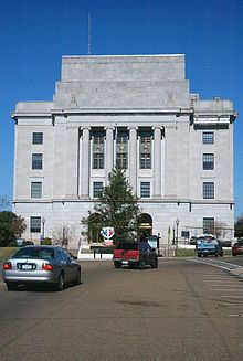
From here, State Line Avenue continues south. One block south of US 67/US 82, the street splits apart. The traffic island in the middle is occupied by the city's U.S. Post Office and Federal Building, the only such building to be located in two states.
Until 1980, State Line Avenue terminated at Texarkana Union Station, but it now ends at Broad Street. At the west end of downtown, the "Texas Viaduct" carries traffic over a rail yard to South State Line Avenue. Approximately five miles (8.0 km) south of the viaduct the road veers eastward, becoming Miller County Road 28, en route to Pleasant Hill.