
 | ||
The thumb wes montgomery
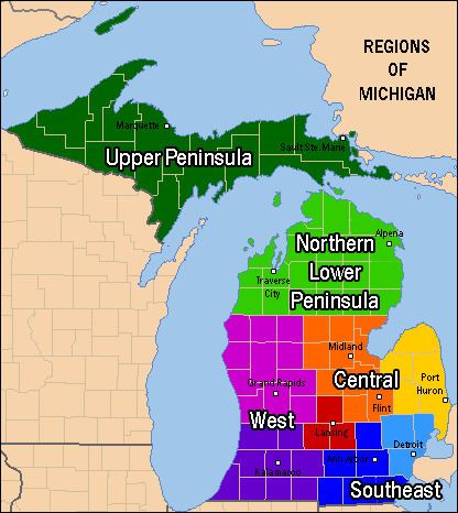
The Thumb is a region and a peninsula of the U.S. state of Michigan, so named because the Lower Peninsula is shaped like a mitten. The Thumb area is generally considered to be in the Central Michigan region, located east of the Tri-Cities, and north of Metro Detroit. The region is also branded as the Blue Water Area of Michigan.
Contents
- The thumb wes montgomery
- Piano lesson on the use of the thumb
- Economy
- Industry
- International Trade Corridor
- Tourism
- Unique to the Thumb
- Traveling around the Thumb
- Lighthouse Tour
- Huron
- Sanilac
- Tuscola
- Lapeer
- St Clair
- Borderline regions
- The Blue Water Area
- Discover the Blue
- Land features
- Major rivers
- Culture
- Historical events
- Notable people by town
- Cass City
- Harbor Beach
- Port Huron
- Deckerville
- Brown City
- Local elected officials
- United States Congress
- Michigan House
- Michigan Senate
- Colleges and universities
- Marysville
- Elsewhere in the Thumb
- Radio
- Newspapers
- Broadcast television
- Borders
- Major highways
- Rail
- Airports
- Area codes
- References
The counties which constitute the Thumb are those forming the extended peninsula that stretches northward into Lake Huron and Saginaw Bay. There is no formal declaration for which of these counties are part of the Thumb. However, virtually all common definitions include Huron, Tuscola, and Sanilac counties. This definition is almost always extended to include Lapeer and St. Clair counties as well.
Piano lesson on the use of the thumb
Economy
The Thumb region is very flat with fertile soil, the reason for its historical role as a chiefly agricultural area. Major agricultural products include sugar beets, navy beans, corn, fruits, and fish from the Saginaw Bay and Lake Huron. Manufacturing - particularly concerning the Automotive Industry - is also prevalent in Michigan's Thumb. Many different types of industries can be found in the thumb, mostly located in the southern portion of the region near the larger metropolitan areas of Detroit and Flint.
Industry
The Thumb has many notable businesses, many linked to agriculture.
International Trade Corridor
The I-69 International Trade Corridor is a strategic commercial gateway between the Midwestern United States and Ontario, Canada, with multi-modal transportation infrastructure that offers a wide range of distribution options.The I-69 International Trade Corridor Next Michigan Development Corporation (NMDC) offers economic incentives to growing businesses, both existing and new, that utilize two or more forms of transportation to move their products and are located within the territory of the NMDC. The I-69 International Trade Corridor Next Michigan Development Corporation is the largest in the state of Michigan with 35 municipal partners.
Constituent counties of the trade corridor are: Shiawassee, Genesee, Lapeer, and St. Clair Counties.
Tourism
Some towns, such as Bay Port, Caseville, Harbor Beach, Lakeport, Lexington, Port Austin, Port Hope, Port Huron, Port Sanilac, Sebewaing, and St. Clair enjoy seasonal tourism, due to their locations on Lake Huron, Saginaw Bay, or St. Clair River. Tourism and farming drive the local economy.
The Tip of The Thumb Heritage Water Trail is a nonprofit citizens organization working with the Huron County Parks to establish and maintain a water trail along Michigan's Lake Huron's shoreline.
Unique to the Thumb
Few of the residents commute for work to Metropolitan Detroit or Flint or the Tri-Cities. Large cities in the Thumb area are Vassar, Port Huron, Lapeer, Marysville, St. Clair, Sandusky, Bad Axe, and Caro. The majority of these cities are in the southern portion of the Thumb.
Unique features in the area include the following:
Traveling around the Thumb
A favorite of tourists who visit this area is traveling the Lake Huron and Saginaw Bay shoreline via M-25 (formerly US Highway 25 until 1973). M-25 starts at the end of I-69/I-94 in Port Huron at the foot of the Blue Water Bridge and ends in Bay City. The whole highway is about 160 miles (260 km), and passes through quaint cities and villages. Located along Lake Huron through which M-25 passes are five lighthouses: Fort Gratiot Lighthouse, Port Sanilac lighthouse, Pointe aux Barques Lighthouse, Harbor Beach Light, and the Port Austin Lighthouse.
The Great Lakes Circle Tour is a designated scenic road system connecting all of the Great Lakes and the St. Lawrence River. Many visitors choose to begin the circle tour in Port Huron, from which they can circle Lake Huron. M-25 winds around the Thumb and along the Saginaw Bay to Saginaw and Bay City. Lexington and Port Austin feature beaches and boardwalks that are favorites with visitors.
Lighthouse Tour
In order from east to west:
Huron
Huron County is located at the tip of the thumb. The county is surrounded on three sides by water – Saginaw Bay and Lake Huron, and has over 90 miles (140 km) of shoreline, from White Rock on Lake Huron to Sebewaing on Saginaw Bay, and more shoreline parks than any other county in the state.
The county's economy relies on agriculture and ranks as one of the top agricultural counties in Michigan. Rich farmland inland produces beans, sugar beets and grain, including most of the world's supply of navy beans. Tourism is also important to Huron County with bay front and lakefront towns such as Sebewaing, Caseville, Port Austin, Port Hope, and Harbor Beach, attracting tourists from all over. Huron County borders the Saginaw Bay and Lake Huron. There are two state parks – Sleeper State Park and Port Crescent State Park. Three roadside parks – Jenks Park, Brown Park, and White Rock Park. Also, Huron County maintains nine county parks along the shoreline, which are Caseville Park, Lighthouse Park, Stafford Park, McGraw Park, Philp Park, Port Austin Bird Creek Park, Wagener Park, Oak Beach Park, and Sebewaing Park.
The county seat is Bad Axe, located in the center of the county.
Sanilac
The County of Sanilac has the largest area of land in The Thumb. Like other counties, Sanilac has fertile and flat land, great for growing crops. Towns like Lexington and Port Sanilac bring in many tourists from the Detroit Area. Sandusky is the county seat and largest city.
Tuscola
Like Huron County, Tuscola is mostly dependent on agriculture. Industries such as sugar refining and ethanol processing, as well as growing various grains and beans, make up most of the economy. Caro, one of the largest cities in The Thumb (the largest if you exclude St. Clair and Lapeer Counties), is named after Cairo, Egypt and is the county seat. Tuscola County only has 18 miles (29 km) of shoreline along Saginaw Bay, so it is not as dependent on tourism as the other counties in the area. Tuscola County is economically tied to the surrounding region as well as to the Saginaw, Bay City, and Flint areas.
Lapeer
The origin of the name of the county is often disputed, but it may have derived from the French words "la pierre", meaning "the stone." This name could be a reference to the rounded stones, or flint pebbles, found in the rivers and streams throughout the area. Another theory, is that it may simply be an English variation of "Le Pays Plat", meaning "the flat land", which is one of the original names given to the area by the French, and can be found on many early fur trader maps of the area. The idea is that "Le Pays" may have evolved into the current pronunciation, "Lapeer."
Lapeer County is in many ways different from the other counties of The Thumb. First, it is heavily influenced by its proximity to Flint and Detroit, so as a result, its economy depends more heavily on manufacturing, than the other counties of the region. Second, although agriculture is still a key economic factor in Lapeer County, it is just not as important to the economy as in the other counties. Although there are still a few large scale farms located in the county, the numbers are not found to the same extent, and these days, most farming in Lapeer now takes place on smaller, independent farms, which usually supply the local markets only. Lastly, in addition to its economic and agricultural differences, Lapeer County's geography is also very different from the other counties of The Thumb. It's topography is generally, gently rolling to quite hilly, and unlike its neighbors, which are flatter, and border on Lake Huron or Lake St. Clair, Lapeer County is landlocked. The County still has hundreds of acres of inland lakes such as Barnes Lake-Miller Lake, Lake Neppessing, The Holloway Reservoir, Big Fish Lake, and Lake Metamora, and several state recreation areas, including the Ortonville Recreation Area and the Metamora-Hadley Recreation Area, which still bring in many campers and tourists.
St. Clair
St. Clair County has the largest population in The Thumb. Many residents farther north in The Thumb, especially Sanilac County, travel to Port Huron for shopping and work. It is the farthest county to the east in Michigan, and most of the eastern border is the St. Clair River, which separates Michigan from Ontario. For the most part, St. Clair County is flat and agriculturally dominating in the north and west, but also has steep hills and small canyons near the Black River, although manufacturing dominates in and around Port Huron.
Borderline regions
Some areas of the thumb are debatable, but nearly all definitions will include Huron, Sanilac, and Tuscola Counties, known as the tri-county region. Disputed areas include:
The Blue Water Area
The Blue Water Area is another term describing the Thumb of Michigan. The term is usually used in respect to St. Clair County, and surrounding areas. The title is also extended to include all of Michigan's Thumb. The name is derived from the flowing blue water of St. Clair River, connecting Lake Huron to Lake St. Clair, and the namesake Blue Water Bridge which spans over the river, connecting Port Huron to Sarnia, Ontario. A similar name, "Blue Water Country" is used to describe the same region on the Canadian side.
Discover the Blue
Discover the Blue is a promotion by the Blue Water Area Convention and Visitor's Bureau to attract visitors to the shoreline of eastern Michigan. Communities participating in Discover the Blue range from Algonac (at the southern end of the Thumb) to Port Austin (at the tip of the Thumb).
Land features
See also List of Michigan state parks and geography of Michigan.
Major rivers
The Thumb has many waterways.
Culture
Persons of European ancestry have formed the overwhelming majority of the population since the late 18th century, and have left the most significant imprint on the culture of The Thumb. The French were the first Europeans to arrive and as a result they influenced much of the early culture. However, the French were mostly engaged in the fur trading and lumber industries, so their settlement of the area was sparse. It wasn't until the British seized control in 1763, after the French and Indian War, that larger numbers of settlers began to arrive. Many of these new settlers were sent into the area by the British from Canada in an effort to establish their dominance over the Great Lakes. In 1783, control of The Thumb was officially transferred to the newly formed United States, after the American Revolution and by the Treaty of Paris. The British however, remained the dominant influence culturally until the War of 1812 firmly established the United States as the owner of the region. This final transfer of control allowed for the organization of the Northwest Territory, and American settlement of Michigan and The Thumb.
As a result of this history, the land was settled mostly by English and Scots-Irish immigrants, many of whom arrived from Canada. Other settlers of the same ancestry migrated from eastern states such as New York, and Pennsylvania, as well as from New England. Later 19th and 20th century residents included Polish and German immigrants who migrated from Europe through the Detroit area. Many of the customs, much of the regional lifestyle, and even the local accent, strongly reflect these origins. Examples include polka shows on some local radio stations, and various ethnic festivals such as the Polkafest, in Kinde.
The European pioneers encountered aboriginal peoples during the settling of the area, which heavily influenced the culture of The Thumb. Most of this interaction was predominately with members of the Fox and Sauk tribes, already living in the area for centuries. There may have also been other tribes in the area such as the Potawatomi, Ojibwe, and Kickapoo, but they would have been transient tribes, or found in very small numbers. All native Thumb area tribes are members of the Algonquian peoples, a large language family. Other tribes who migrated later into the area included the Wyandot (Huron), an Iroquoian language-speaking people; and the Ottawa. The displacement of native peoples was part of the history of the settling of North America, and most of the area has been developed along the model of European-American practices.
Historical events
Notable people (by town)
More comprehensive lists are available at individual cities, villages, etc. See local towns of interest at the bottom of the page for links.
Cass City
Harbor Beach
Lapeer
Port Huron
Deckerville
Brown City
Local elected officials
Local politicians in Washington and Lansing are listed below.
United States Congress
District 10 - Northern Macomb, and all of St Clair, Lapeer, Sanilac, and Huron County.
District 5 - Saginaw/Bay City Area, and all of Genesse and Tuscola.
Michigan House
32nd District - Northern Macomb and six townships in St Clair County.
81st District - Most of St Clair County, except Port Huron.
82nd District - All of Lapeer County.
83rd District - City of Port Huron, Fort Gratiot, and all of Sanilac County.
84th District - Huron and Tuscola County.
Michigan Senate
25th District - St. Clair and Lapeer Counties.
Colleges and universities
Harbor Beach
Marysville
Port Huron
* Port Huron Museum - a series of five museums - Port Huron
Elsewhere in the Thumb
Radio
The Thumb Area Radio Region is an unranked market that is influenced by Detroit Radio Market, the Tri-Cities Radio Market and the Flint Market, with stations in Port Huron and Sarnia, Ontario also serving the region.
Newspapers
Broadcast television
The Lapeer County, St. Clair County and Sanilac County area lies in the Detroit Television Market. The far northern and western areas lie inside the Flint/Tri-Cities Television Market. The only broadcast TV station licensed to the Thumb region is WDCQ-TV, the PBS station licensed to Bad Axe.
Borders
The border between Port Huron, Michigan and Sarnia, Ontario is one of the busiest connections between Canada and the US. Crossings include the two Blue Water Bridges and the two St. Clair River Railway Tunnels. Ferries also connect to Canada at Marine City and Algonac.
Major highways
(organized by numbers)
Rail
Area Amtrak stations are in Lapeer, Port Huron, and Flint. Local railroads are the Grand Trunk Western Railroad, CSX Transportation, Canadian National Railway, and the Huron and Eastern Railway. Pere Marquette Railway was a railroad that had lines throughout the Thumb; its lines are now either abandoned or in use by CSX, or Huron and Eastern.
Major railroad centers are Vassar, Bad Axe and Port Huron.
Airports
The only international airport in the Thumb is St. Clair County International Airport about 6 miles (9.7 km) outside Port Huron. City airports include: Caro Municipal, Dupont-Lapeer Airport, Huron County Memorial Airport, Marine City Airport, Marlette Municipal, Sandusky City, and Yale Airport. Scheduled airline service is available from MBS International Airport in Freeland, Michigan and Flint Bishop International Airport. While neither of these airports is in the Thumb, both are relatively close by.
Area codes
Area code 989 covers about half of the Thumb: Huron, Tuscola, and far northern Sanilac County (and the Marlette, Michigan area). The Thumb's other half is covered by area code 810, which takes in most of Sanilac, Lapeer, Genesee and Saint Clair Counties. All of Macomb County is served by area code 586, as is a small part of south-western Saint Clair County.