
Location (Great Lakes) Primary outflows Detroit River Max. length 26 mi (42 km) Width 39 km Mean depth 3.35 m | Type Fresh water lake Basin countries Canada, United States Area 1,114 km² Surface elevation 175 m | |
 | ||
Primary inflows Fish Muskellunge, Northern pike, Rainbow trout, Walleye, Bluegill Similar Detroit River, Lake Huron, Lake Erie, Lake Michigan, Harsens Island | ||
Bassmaster elite series lake st clair 2015
Lake St. Clair (French: Lac Sainte-Claire) is a freshwater lake that lies between the Canadian province of Ontario and the U.S. state of Michigan. It was named after Clare of Assisi, on whose feast day it was navigated and christened by French Catholic explorers in 1679. It is part of the Great Lakes system, and along with the St. Clair River and Detroit River, Lake St. Clair connects Lake Huron (to its north) with Lake Erie (to its south). It has a total surface area of about 430 square miles (1,100 km2) and average depth of just 11 ft (3.4 m); to ensure an uninterrupted waterway, government agencies on both sides of the lake have maintained a deep shipping channel through the shallow lake for more than a century.
Contents
- Bassmaster elite series lake st clair 2015
- Map of Lake St Clair
- Muskie fishing on lake st clair
- GeographyEdit
- NamingEdit
- Water qualityEdit
- Boat clubsEdit
- Public beachesEdit
- References
Map of Lake St Clair
Muskie fishing on lake st clair
GeographyEdit
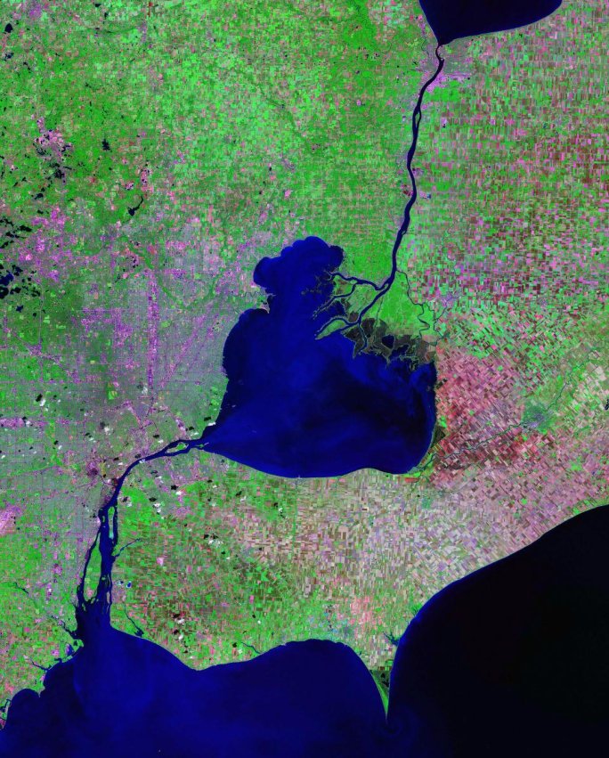
This lake is situated about 6 miles (10 km) northeast of the downtown areas of Detroit, Michigan, and Windsor, Ontario. Along with the St. Clair River and Detroit River, Lake St. Clair connects Lake Huron (to its north) with Lake Erie (to its south); the area is notable for the fact that the Canadian territory around the lake (Windsor metropolitan area) lies south of the adjacent United States territory.
Lake Saint Clair measures about 22.5 nautical miles (42 km; 26 mi) from north to south and about 21 nautical miles (39 km; 24 mi) from east to west. Its total surface area is about 430 square miles (1,100 km2). This is a rather shallow lake for its size, with an average depth of about 11 feet (3.4 m), and a maximum natural depth of 21.3 feet (6.5 m). However, it is 27 feet (8.2 m) deep in the navigation channel which has been dredged for lake freighter passage. The lake is fed by the St. Clair River, which flows southwards from Lake Huron and has an extensive river delta where it enters Lake Saint Clair. This is the largest delta of the Great Lakes System. Also, the Thames River and Sydenham River flow into Lake Saint Clair from Southwestern Ontario, and the Clinton River and Pine River (Michigan) flows into it from Michigan. The outflow from Lake Saint Clair flows from its southwestern end into the Detroit River, and thence into Lake Erie.
The tarry time (i.e. the time between entering and leaving) of the water in Lake St. Clair averages about seven days, but this can vary from as little as two to as many as thirty days, depending on the direction of the winds, the water circulation patterns, and the amount of water that is flowing out of Lake Huron. If water flows through the navigation channel, which is maintained by the U.S. Army Corps of Engineers, the time the water remains in the lake is about two days.
This lake is part of the Great Lakes System. Because it is 17 times smaller in area than Lake Ontario, it is rarely included in the listings of the Great Lakes but is sometimes referred to as "the sixth Great Lake". There are isolated proposals for its official recognition as a Great Lake, which would affect its inclusion in scientific research projects, etc., designated as being for "The Great Lakes".
NamingEdit
First Nations/Native Americans used the lake as part of their extensive navigation of the Great Lakes. The Mississaugas called present-day Lake St. Clair Waawiyaataan(ong), "(At) the whirlpool", and the Wea tribe's name derived from the lake's Miami cognate Waayaahtanonki. The Mississaugas established a village near the lake in the latter part of the 17th century. Early French mapmakers had identified the lake by a variety of French and Iroquois names, including Lac des Eaux de Mer [Seawater Lake]; Lac Ganatchio ("kettle," for its shape), in French Lac de la Chaudière. A variety of Native names were associated with sweetness, as the lake was freshwater as opposed to saltwater. These included Otsiketa (sugar or candy), Kandequio or Kandekio (possibly candy), Oiatinatchiketo (probably a form of Otsiketa), and Oiatinonchikebo. Similarly, the Iroquois called present-day Lake Huron, "The Grand Lake of the Sweet Sea" (fresh water as opposed to salt water.) This association was conveyed on French maps as Mer Douce (sweet sea) and Dutch maps as the Latin Mare Dulce.
On August 12, 1679, the French explorer René Robert Cavelier, Sieur de La Salle arrived with an expedition. He named the body of water Lac Sainte-Claire as the expedition discovered it on the feast day of Saint Clare of Assisi. The historian on the voyage, Louis Hennepin, recorded that the Iroquois called the lake Otseketa.
As early as 1710, the English identified the lake on their maps as Saint Clare. By the Mitchell Map in 1755, the spelling appeared as St. Clair, the form that became most widely used. Some scholars credit the name as honoring the American Revolutionary War General Arthur St. Clair, later Governor of the Northwest Territory, but the name Lake St. Clair was in use with the current spelling long before St. Clair became a notable figure. Together the place name and general's name likely influenced settlers' naming a proliferation of nearby political jurisdictions: the Michigan county and township of St. Clair, as well as the cities of St. Clair and St. Clair Shores.
The origin of the name has also been confused with one Patrick Sinclair, a British officer who purchased land on the St. Clair River at the outlet of the Pine River. There, in 1764, he built Fort Sinclair, which was in use for nearly twenty years before being abandoned.
Unlike most smaller lakes in the region – but like the Great Lakes – Lake comes at the front of its proper name, rather than the end; this is reflective of its French origins.
Water qualityEdit
Lake St Clair's location, downstream from the largest freshwater delta in the Great Lakes, has a large effect on its turbidity (clarity). Current water quality is quite good despite past incidents and a history of chemical bio-accumulation. A number of cities source drinking water from or just downstream of the lake and quality is closely monitored.
In the early 1970s, the Canadian and American governments closed the commercial fishery over concerns of bio-accumulation of mercury. The industry responsible for this contamination was the Dow Chemical Chlor-Alkali Plant in Sarnia, Ontario. Since 1949, Dow Chemical had been operating mercury cell plants for the production of chlorine and other chemicals. From their production process, mercury was being discharged into the river and contaminating the fishery. The fishery has since not been re-opened, although studies have now confirmed mercury levels are well within safe range.
Sport fishing remains popular in the lake, having some of the best fishing in the world. The governments on both sides of the lakes continue to monitor and publish guides for sport fish consumption.
Boat clubsEdit
Many yacht clubs (boating and sailing clubs) are located along the shores. Some of which include: