
Country United States Time zone Eastern (EST) (UTC-5) Area 17.4 km² Zip code 48623 Area code Area code 989 | FIPS code 26-30540 Elevation 189 m Population 5,147 (2000) | |
 | ||
Freeland is an unincorporated community in Tittabawassee Township, Saginaw County of the U.S. state of Michigan. It is also a census-designated place (CDP) for statistical purposes and without any legal status as an incorporated municipality. As of the 2000 census, the CDP population was 5,147. The CDP covers an area in the central portion of Tittabawassee Township. The Freeland post office, ZIP code 48623, serves nearly the entire township, as well as portions of Midland and Williams townships to the north, Frankenlust and Kochville townships to the east, Thomas and Richland townships to the south, and Ingersoll Township to the west.
Contents
Map of Freeland, MI 48623, USA
It is the location of MBS International Airport, which serves three major nearby cities: Saginaw, Bay City and Midland.
It is also the location of the Saginaw Correctional Facility, which is a level I, II and IV maximum security prison.
History
The place was home to Native Americans long before the arrival of settlers of European ancestry. In the 1819 Treaty of Saginaw, in which the Chippewa, Ottawa, and Pottawatomi ceded a large portion of land including Saginaw County to the United States federal government. In that treaty, within the ceded territory, several tracts were reserved for specific groups of Chippewa. One such tract, Black Bird's Village, consisted of 6,000 acres (24 km2) on the Tittawabassee (named as the Tetabawasink river in the text of the treaty), very near to the present location of Freeland.
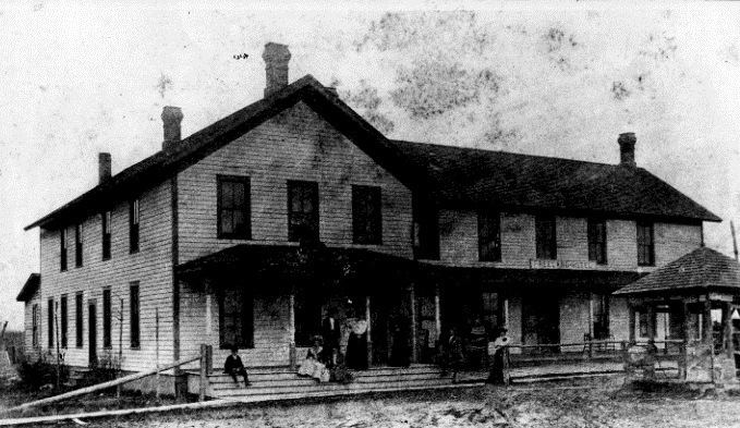
In the 1850s, lumbering outposts developed in the area, one of which was called "Loretta", which was given a post office named "Jay" in April 1856. The office was named for the first postmaster, Jefferson Jaqruth. This outpost was very nearly at the geographical center of Tittawabasse Township. Another settlement was placed just a little to the north. in 1867, one resident of the second locale, George Truesdale, instigated moving the post office from Loretta to his settlement, which retained the name of Jay for several years afterwards.
The name of Freeland comes from "Mammy Freeland" who operated a popular tavern on the river, frequented by lumbermen and rivermen, who came to refer to the entire settlement as Freeland. The name of the post office was changed to Freeland in January 1879. It was also a station on the Pere Marquette Railroad. By another account (Moore), the Freeland family name was prominent in business and politics of the area.
During World War II, the airport was used to hold German prisoners of war.
Geography
According to the United States Census Bureau, the CDP has a total area of 6.7 square miles (17 km2), of which 6.7 square miles (17 km2) is land and 0.04 square miles (0.10 km2) (0.45%) is water.
2000 Census
As of the census of 2000, there were 5,147 people, 1,441 households, and 1,115 families residing in the CDP. The population density was 769.7 per square mile (297.1/km²). There were 1,527 housing units at an average density of 228.3 per square mile (88.1/km²). The racial makeup of the CDP was 82.86% White, 13.04% African American, 0.64% Native American, 0.49% Asian, 0.06% Pacific Islander, 0.82% from other races, and 2.10% from two or more races. Hispanic or Latino of any race were 3.17% of the population.
There were 1,441 households out of which 40.8% had children under the age of 18 living with them, 65.4% were married couples living together, 9.0% had a female householder with no husband present, and 22.6% were non-families. 18.5% of all households were made up of individuals and 5.6% had someone living alone who was 65 years of age or older. The average household size was 2.68 and the average family size was 3.08.
In the CDP, the population was spread out with 22.1% under the age of 18, 7.9% from 18 to 24, 43.3% from 25 to 44, 20.3% from 45 to 64, and 6.4% who were 65 years of age or older. The median age was 34 years. For every 100 females there were 161.1 males. For every 100 females age 18 and over, there were 182.6 males.
The median income for a household in the CDP was $55,455, and the median income for a family was $67,083. Males had a median income of $50,225 versus $33,306 for females. The per capita income for the CDP was $20,470. About 2.7% of families and 2.6% of the population were below the poverty line, including 2.0% of those under age 18 and 6.5% of those age 65 or over.
Climate
This climatic region is typified by large seasonal temperature differences, with warm to hot (and often humid) summers and cold (sometimes severely cold) winters. According to the Köppen Climate Classification system, Freeland has a humid continental climate, abbreviated "Dfb" on climate maps.