
Congressional district 4th Website www.shiawassee.net Population 68,900 (2013) Unemployment rate 5.1% (Apr 2015) | Area 1,401 km² | |
 | ||
Founded September 10, 1822 (created)1837 (organized) Destinations Points of interest Curwood Castle, Steam Railroading Institute, McCurdy Park, DeVries Nature Conservancy, Corunna Historical Village | ||
Shiawassee /ˌʃaɪ.əˈwɒsiː/ is a county located in the U.S. state of Michigan. As of the 2010 census, the population was 70,648. The county seat is Corunna. The county was founded in 1822 and organized in 1837. Shiawassee County is named for the Shiawassee River, and means 'river that twists about'.
Contents
- Map of Shiawassee County MI USA
- Geography
- Adjacent counties
- Highways
- Rail
- Airport
- Demographics
- Government
- Elected officials
- Cities
- Villages
- Census designated places
- References
Map of Shiawassee County, MI, USA
In 2010, the center of population of Michigan was located in Shiawassee County, in the township of Bennington.
Shiawassee County comprises the Owosso, MI Micropolitan Statistical Area and is included in the Lansing-East Lansing-Owosso, MI Combined Statistical Area.
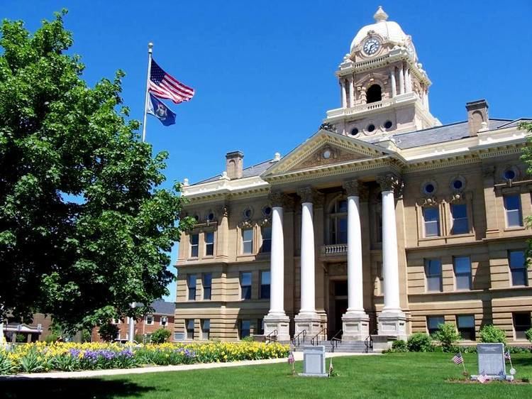
The Shiawassee County Courthouse was designed by Claire Allen, a prominent southern Michigan architect.
Geography
According to the U.S. Census Bureau, the county has a total area of 541 square miles (1,400 km2), of which 531 square miles (1,380 km2) is land and 10 square miles (26 km2) (1.9%) is water. The Shiawassee River enters it from Genesee County in the southeast and flows through Corunna and Owosso in the center of the county, exiting to Saginaw County in the north. Shiawassee County is considered to be a part of Central Michigan.
Adjacent counties
Highways
Rail
Airport
Owosso Community Airport near Owosso is a general use public airport, used by small private planes.
Demographics
As of the 2010 census indicates Shiawassee County had a 2010 population of 70,648. This is a decrease of -1,039 people from the 2000 United States Census. Overall, the county had a -1.4% growth rate during this ten-year period. In 2010 there were 27,481 households and 19,397 families in the county. The population density was 133.1 per square mile (51.4 square kilometers). There were 30,319 housing units at an average density of 57.1 per square mile (22.0 square kilometers). 96.7% of the population were White, 0.5% Native American, 0.5% Black or African American, 0.4% Asian, 0.5% of some other race and 1.5% of two or more races. 2.4% were Hispanic or Latino (of any race). 22.2% were of German, 21.8% English, 9.5% Irish, 5.2% French, French Canadian or Cajun and 5.1% Polish ancestry according to 2010 American Community Survey.
There were 27,481 households out of which 32.5% had children under the age of 18 living with them, 53.8% were husband and wife families, 11.6% had a female householder with no husband present, 29.4% were non-families, and 24.2% were made up of individuals. The average household size was 2.54 and the average family size was 2.99.
In the county, the population was spread out with 24.1% under age of 18, 8.5% from 18 to 24, 23.9% from 25 to 44, 29.1% from 45 to 64, and 14.3% who were 65 years of age or older. The median age was 40 years. For every 100 females there were 97.7 males. For every 100 females age 18 and over, there were 94.6 males.
The 2010 American Community Survey 1-year estimate indicates the median income for a household in the county was $46,528 and the median income for a family was $52,614. Males had a median income of $32,155 versus $19,301 for females. The per capita income for the county was $21,103. About 10.6% of families and 15.4% of the population were below the poverty line, including 22.1% of those under the age 18 and 5.8% of those age 65 or over.
Government
The county government operates the jail, maintains rural roads, operates the major local courts, keeps files of deeds and mortgages, maintains vital records, administers public health regulations, and participates with the state in the provision of welfare and other social services. The county board of commissioners controls the budget but has only limited authority to make laws or ordinances. In Michigan, most local government functions — police and fire, building and zoning, tax assessment, street maintenance, etc. — are the responsibility of individual cities and townships.
Elected officials
(information as of January 2017)