
OS grid NY215072 Prominence 912 m | Elevation 978 m First ascender Samuel Taylor Coleridge | |
 | ||
Topo map OS Landrangers 89, 90, Explorer OL6 Similar | ||
Hiking scafell pike the highest mountain in england 2 3
Scafell Pike /ˈskɔːˈfɛl/ or /skɑːˈfɛl/ is the highest mountain in England, at an elevation of 978 metres (3,209 ft) above sea level. It is located in the Lake District National Park, in Cumbria, and is part of the Southern Fells.
Contents
- Hiking scafell pike the highest mountain in england 2 3
- Map of Scafell Pike Seascale UK
- Hiking scafell pike highest mountain in england
- TopographyEdit
- SummitEdit
- GeologyEdit
- TourismEdit
- Naming historyEdit
- Survey pointEdit
- Visible MarilynsEdit
- NorthEdit
- EastEdit
- SouthEdit
- WestEdit
- References
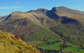
Map of Scafell Pike, Seascale, UK
Hiking scafell pike highest mountain in england
TopographyEdit
Scafell Pike is one of a horseshoe of high fells, open to the south, surrounding the head of Eskdale, Cumbria. It stands on the western side of the cirque, with Scafell to the south and Great End to the north. This ridge forms the watershed between Eskdale and Wasdale, which lies to the west.
The narrowest definition of Scafell Pike begins at the ridge of Mickledore in the south, takes in the wide, stony summit area and ends at the next depression, Broad Crag Col, c. 920 m (3,030 ft). A more inclusive view also takes in two further tops: Broad Crag, 934 m (3,064 ft) and Ill Crag, 935 m (3,068 ft), the two being separated by Ill Crag Col. This is the position taken by most guidebooks. North of Ill Crag is the more definite depression of Calf Cove at 850 m (2,800 ft), before the ridge climbs again to Great End.
Scafell Pike also has outliers on either side of the ridge. Lingmell, to the north west, is invariably regarded as a separate fell, while Pen, 760 m (2,500 ft), a shapely summit above the Esk, is normally taken as a satellite of the Pike. Middleboot Knotts is a further top lying on the Wasdale slopes of Broad Crag, which is listed as a Nuttall.
The rough summit plateau is fringed by crags on all sides with Pikes Crag and Dropping Crag above Wasdale and Rough Crag to the east. Below Rough Crag and Pen is a further tier, named Dow Crag and Central Pillar on Ordnance Survey maps, although known as Esk Buttress among climbers. Esk Buttress and Pikes Crag are well known rock climbing venues.
Broad Crag Col is the source of Little Narrowcove Beck in the east and of Piers Gill in the west. The latter works its way around Lingmell to Wast Water through a spectacular ravine, one of the most impressive in the Lake District. It is treacherous in winter, as when it freezes over it creates an icy patch, with lethal exposure should you slip. Broad Crag is a small top with its principal face on the west and the smaller Green Crag looking down on Little Narrowcove. From Broad Crag, the ridge turns briefly east across Ill Crag Col and onto the shapely pyramidal summit of Ill Crag. Here, the main crags are on the Eskdale side, Ill Crag having little footing(clarify) in Wasdale.
Scafell Pike has a claim to the highest standing water in England, although Foxes Tarn on Scafell is of similar height. The water body in question is Broad Crag Tarn, which (confusingly) is on Scafell Pike proper, rather than Broad Crag. It lies at about 820 m (2,700 ft), a quarter of a mile south of the summit.
The summit ridge from Ill Crag to Mickledore is notoriously stony, the surface being composed in many places of fields of boulders. Paths are not marked by the usual erosion of soil, but by coloured marks on the rock following the passage of many thousands of booted feet. The summits of Ill and Broad Crags are bypassed by the ridge path, but it leads unerringly to the highest point. This bears an Ordnance Survey triangulation column beside a massive cairn, not now in the best of repair, but unmistakable from any distance, still six feet high and much greater in diameter. A little distance away is the lower south peak.
SummitEdit
The summit was donated to the National Trust in 1919 by Lord Leconfield "in perpetual memory of the men of the Lake District who fell for God and King, for freedom peace and right in the Great War 1914 – 1918 ...". There is a more well-known war memorial on Great Gable, commemorating the members of the Fell & Rock Climbing Club.
Scafell Pike is one of three British peaks climbed as part of the National Three Peaks Challenge, and is the highest ground for over 90 miles.
GeologyEdit
Scafell Pike consists of igneous rock dating from the Ordovician; it is geologically part of the Borrowdale Volcanics. The summit plateau of Scafell Pike, and that of other neighbouring peaks, is covered with shattered rock debris which provides the highest-altitude example of a summit boulder field in England. The boulder field is thought to have been caused in part by weathering, such as frost action. Additional factors are also considered to be important; however, opinion varies as to what these may be. James Clifton Ward suggested that weathering with earthquakes as a secondary agent could be responsible, while John Edward Marr and Reginald Aldworth Daly believed that earthquakes were unnecessary and suggested that frost action with other unspecified agents was more likely. To the north of the summit are a number of high altitude gills which flow into Lingmell Beck. These are good examples in Cumbria for this type of gill and are also biologically important due to their species richness.
The peak has outcrops of fine-grained greenstone or hornstone suitable for making polished stone axes. Such axes have been found distributed across Great Britain. The rock is an epidotised greenstone quarried or perhaps just collected from the scree slopes in the Langdale Valley on Harrison Stickle and Pike of Stickle. The nature and extent of the axe-flaking sites making up the Langdale axe industry complex are still under investigation. Geological mapping has established that the volcanic tuff used for the axes outcrops along a narrow range of the highest peaks in the locality.
TourismEdit
Scafell Pike is a popular destination for walkers. There is open access to Scafell and the surrounding fells, with many walking and rock climbing routes. Paths connect the summit with Lingmell Col to the northwest, Mickledore to the southwest, and Esk Hause to the northeast, and these in turn connect with numerous other paths, giving access to walkers from many directions including Wasdale Head to the west, Seathwaite to the north, Langdale to the east, and Eskdale to the southwest. The shortest route is from Wasdale Head, about 80 metres above sea level, where there is a famous climber's hotel, the Wasdale Head Inn, made popular in the Victorian period by Owen Glynne Jones and others. According to the National Trust, as of 2014 there were over 100,000 people per year climbing Scafell Pike from Wasdale Head, many as part of the National Three Peaks Challenge.
Naming historyEdit
The name Scafell is believed by some to derive from the Old Norse skalli fjall, meaning either the fell with the shieling or the fell with the bald summit, and is first recorded in 1578 in the corrupted form Skallfield. It originally referred to Scafell, which neighbours Scafell Pike. What are now known as Scafell Pike, Ill Crag, and Broad Crag were collectively called either the Pikes (peaks) or the Pikes of Scafell; from many angles Scafell seems to be the highest peak, and the others were thus considered subsidiary to it. The name Scafell Pike was adopted between 1818 and 1856. Before this, England's highest mountain (its status as such was not known until the early 1800s) did not have a name of its own, and was labelled Sca-Fell Higher Top by the Ordnance Survey in their initial work in Cumbria. This did not appear on a published Ordnance Survey map until 1865.
Formerly the name was spelled Scawfell, which better reflects local pronunciation. This spelling has declined due to the Ordnance Survey's preference for Scafell.
Survey pointEdit
Scafell Pike was used in 1826 as a station in the Principal Triangulation of Britain by the Ordnance Survey when they fixed the relative positions of Britain and Ireland. Angles between Slieve Donard and Snowdon were taken from Scafell Pike, as were angles measured from stations on each of the other two mountains. Given the need for clear weather to achieve these very long range observations (111 miles to Slieve Donard), the Ordnance surveyors spent most of the summer camped on the respective mountain tops. Strangely, Scafell Pike was not used as a station in the earlier part of the Principal Triangulation (up to 1809) of Britain, even though Sca-Fell formed one corner of a Principal Triangle.
Visible "Marilyns"Edit
As the highest ground in England, Scafell Pike naturally has a very extensive view, ranging from the Mourne Mountains to Snowdonia. On a clear day, the following Marilyns can be seen from the summit.
The data is from the first 'external link' below.