
OS grid SH6098954379 Elevation 1,085 m Prominence 1,038 m | Parent range Snowdonia Topo map OS Landranger 115 First ascent 1639 Mountain range Snowdon Massif Owner Snowdonia | |
 | ||
Similar | ||
North wales snowdonia top attractions uk study tours
Snowdon (Welsh: Yr Wyddfa, [ər ˈwɪðva]) is the highest mountain in Wales, at an elevation of 1,085 metres (3,560 ft) above sea level, and the highest point in the British Isles south of the Scottish Highlands. It is located in Snowdonia National Park (Parc Cenedlaethol Eryri) in Gwynedd, and has been described as "probably the busiest mountain in Britain". It is designated as a national nature reserve for its rare flora and fauna.
Contents
- North wales snowdonia top attractions uk study tours
- Map of Snowdon Caernarfon UK
- HeightEdit
- FloraEdit
- GeologyEdit
- ClimateEdit
- LakesEdit
- Rock climbingEdit
- AscentsEdit
- Llanberis PathEdit
- Snowdon Ranger PathEdit
- Rhyd Ddu PathEdit
- Watkin PathEdit
- Over Y LliweddEdit
- Miners TrackEdit
- Pyg TrackEdit
- Crib Goch routeEdit
- Snowdon Mountain RailwayEdit
- View from the summitEdit
- Summit buildingsEdit
- FolkloreEdit
- References
Map of Snowdon, Caernarfon, UK
The rocks that form Snowdon were produced by volcanoes in the Ordovician period, and the massif has been extensively sculpted by glaciation, forming the pyramidal peak of Snowdon and the arêtes of Crib Goch and Y Lliwedd. The cliff faces on Snowdon, including Clogwyn Du'r Arddu, are significant for rock climbing, and the mountain was used by Edmund Hillary in training for the 1953 ascent of Mount Everest.
The summit can be reached by a number of well-known paths, and by the Snowdon Mountain Railway, a rack and pinion railway opened in 1896 which carries passengers the 4.7 miles (7.6 km) from Llanberis to the summit station. The summit also houses a cafe called Hafod Eryri, open only when the railway is operating and opened in 2009 to replace one built in the 1930s. The railway generally operates to the summit station from Whitsun to October. The daily running schedule depends on weather and customer demand.
The name Snowdon is from the Old English for "snow hill", while the Welsh name – Yr Wyddfa – means "the tumulus" or "the barrow", which may refer to the cairn thrown over the legendary giant Rhitta Gawr after his defeat by King Arthur. As well as other figures from Arthurian legend, the mountain is linked to a legendary afanc (water monster) and the Tylwyth Teg (fairies).
HeightEdit
A 1682 survey estimated that the summit of Snowdon was at a height of 3,720 feet (1,130 m); in 1773, Thomas Pennant quoted a later estimate of 3,568 ft (1,088 m) above sea level at Caernarfon. Recent surveys give the height of the summit as 1,085 m (3,560 ft), making Snowdon the highest mountain in Wales, and the highest point in the British Isles outside Scotland. Snowdon is one of three mountains climbed as part of the National Three Peaks Challenge.
FloraEdit
The unique environment of Snowdon, particularly its rare plants, has led to its designation as a national nature reserve. In addition to plants that are widespread in Snowdonia, Snowdon is home to some plants rarely found elsewhere in Britain. The most famous of these is the "Snowdon lily", Gagea serotina, which is also found in the Alps and in North America; it was first discovered in Wales by Edward Lhuyd, and the genus Lloydia (now included in Gagea) was later named in his honour by R. A. Salisbury. Snowdon lies in the northern part of Snowdonia National Park, which has also provided some legal protection since the park's establishment in 1951.
GeologyEdit
The rocks which today make up Snowdon and its neighbouring mountains were formed in the Ordovician Period. At that time, most of modern-day Wales was near the edge of Avalonia, submerged beneath the ancient Iapetus Ocean. In the Soudleyan stage (458 to 457 million years ago) of the Caradoc age, a volcanic caldera formed, and produced ash flows of rhyolitic tuff, which formed deposits up to 500 metres (1,600 ft) thick. The current summit is near the northern edge of the ancient caldera; the caldera's full extent is unclear, but it extended as far as the summit of Moel Hebog in the south-west.
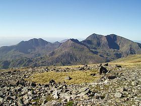
Snowdon and its surrounding peaks have been described as "true examples of Alpine topography". The summits of Snowdon and Garnedd Ugain are surrounded by cwms, rounded valleys scooped out by glaciation. Erosion by glaciers in adjacent cwms caused the characteristic arêtes of Crib Goch, Crib y Ddysgl and Y Lliwedd, and the pyramidal peak of Snowdon itself. Other glacial landforms that can be seen around Snowdon include roches moutonnées, glacial erratics and moraines.
ClimateEdit
The English name "Snowdon" comes from the Old English snaw dun, meaning "snow hill", as Snowdon often has a covering of snow. Although the amount of snow on Snowdon in winter varies significantly, 55% less snow fell in 2004 than in 1994. The slopes of Snowdon have one of the wettest climates in Great Britain, receiving an annual average of more than 200 inches (5,100 mm) of precipitation.
LakesEdit
A number of lakes are found in the various cwms of the Snowdon range.
Other lakes include Llyn Du'r Arddu below Clogwyn Du'r Arddu – 1,901 feet (579 m) high, 5 acres (2.0 ha), Llyn Teyrn near Pen-y-pass – 1,237 feet (377 m) high, 5 acres (2.0 ha), and several smaller pools.
Rock climbingEdit
The Snowdon Massif includes a number of spectacular cliffs, and holds an important place in the history of rock climbing in the United Kingdom. Clogwyn Du'r Arddu is often colloquially known as 'Cloggy' among climbers, and was the site of the first recorded climb in Britain, in 1798. It was carried out by Peter Bailey Williams and William Bingley, while searching for rare plants. It is now considered to be one of the best cliffs in Britain for rock climbing.
Y Lliwedd was also explored by early climbers, and was the subject of a 1909 climbing guide, The Climbs on Lliwedd by J. M. A. Thompson and A. W. Andrews, one of the first in Britain. Snowdon was used by Edmund Hillary and his group during preparations for their successful 1953 expedition to climb Mount Everest.
AscentsEdit
The first recorded ascent of Snowdon was by the botanist Thomas Johnson in 1639. However, the 18th-century Welsh historian Thomas Pennant mentions a "triumphal fair upon this our chief of mountains" following Edward I's conquest of Wales in 1284, which could indicate the possibility of earlier ascents.
Snowdon offers some of the most extensive views in the British Isles. On exceptionally clear days, Ireland, Scotland, England, and the Isle of Man are all visible, as well as 24 counties, 29 lakes and 17 islands. The view between Snowdon and Merrick (southern Scotland) is the longest theoretical line of sight in the British Isles at 144 miles (232 km).
Snowdon has been described as "probably the busiest mountain in Britain", with approximately 444,000 people having walked up the mountain in 2016. A number of well-established and engineered footpaths lead to Snowdon's summit from all sides, and can be combined in various ways. The circular walk starting and ending at Pen-y-Pass and using the Crib Goch route and the route over Y Lliwedd is called the Snowdon Horseshoe, and is considered "one of the finest ridge walks in Britain". The routes are arranged here anticlockwise, starting with the path leading from Llanberis. In winter conditions, all these routes become significantly more dangerous and the Llanberis Mountain Rescue Team state that "additional skills, equipment and knowledge are required". Many inexperienced walkers have been killed over the years attempting to climb the mountain via the main paths.
These six main paths were mapped by the Google Trekker in 2015.
Llanberis PathEdit
The Llanberis Path is the longest route to the summit, and has the shallowest gradient. It largely follows the line of the Snowdon Mountain Railway, and is considered the easiest and least interesting route to the summit of Snowdon. It is the route used by the annual Snowdon Race, with a record time of less than 40 minutes recorded from the start to the summit.
The section of the Llanberis Path beside the railway near the summit has been called the "Killer Convex"; in icy conditions, this convex slope can send unwary walkers over the cliffs of Clogwyn Du'r Arddu. Four people died there in February 2009.
Snowdon Ranger PathEdit
The Snowdon Ranger Path (Welsh: Llwybr Cwellyn) begins at the youth hostel beside Llyn Cwellyn, to the west of the mountain, served by the A4085 and Snowdon Ranger railway station. This was formerly the Saracen's Head Inn, but was renamed under the ownership of the mountain guide John Morton. It is "probably the oldest path to the summit".
The route begins with zigzags through "lush green turf", before reaching a flatter boggy area in front of Llyn Ffynnon-y-gwas. The path then climbs to Bwlch Cwm Brwynog, and then snakes along the ridge above Clogwyn Du'r Arddu towards the summit. This path meets the railway, the Llanberis Path, the Crib Goch path, and the combined Pyg Track and Miners' Track all within a short distance, just below the summit.
Rhyd Ddu PathEdit
The Rhyd Ddu path, also called the Beddgelert Path, leads from the village of Rhyd Ddu, west of Snowdon, gently up on to Llechog, a broad ridge dropping west from the summit. It is considered one of the easier routes to the summit, with the advantage that the summit is visible from the start, but is one of the least used routes. It climbs at a shallow gradient to Bwlch Main, shortly southwest of the summit, from where it climbs more steeply, meeting up with the Watkin Path at a site marked with a large standing stone a few hundred metres from the summit. An alternative start begins at Pitt's Head on the A4085 road.
Watkin PathEdit
The Watkin Path is "the most demanding route direct to the summit of Snowdon", since it starts at the lowest elevation of any of the main routes. It was first conceived by Edward Watkin, a railway owner who had attempted to build a railway tunnel under the English Channel, and had a summer home in Nant Gwynant near the start of the path. It was originally designed as a donkey track and opened in 1892.
The start of the Watkin Path has been described as "the prettiest beginning" of the routes up Snowdon. It begins at Bethania on the A498 and climbs initially through old broadleaved woodland. After leaving the woods, the path climbs past the waterfalls of the Afon Llan to the glacial cirque of Cwm Llan, crossing a disused incline from an abandoned slate quarry. It then reaches Plas Cwmllan, formerly the home of the quarry manager for the South Snowdon Slate Works beyond, and later used for target practice by commandos during the Second World War. Near Plas Cwmllan is the large boulder known as Gladstone Rock, which bears a plaque commemorating a speech given in 1892 by William Ewart Gladstone, the then 83-year-old Prime Minister, on the subject of Justice for Wales. The slate workings in Cwm Llan were opened in 1840, but closed in 1882 due to the expense of transporting the slate to the sea at Porthmadog. Various buildings, including barracks and dressing sheds, remain.
From the slate quarries, the Watkin Path veers to the north-east to reach Bwlch Ciliau, the col between Snowdon and Y Lliwedd, which is marked by a large orange-brown cairn. From here, it heads west to meet the Rhyd Ddu Path at a standing stone shortly below the summit of Snowdon.
Scenes from Carry On... Up the Khyber were filmed on the lower part of the Watkin Path in 1968, with the Watkin Path representing the Khyber Pass in the film. In 2005 one of the stars of the film, Angela Douglas, unveiled a plaque at the precise location where filming took place, to commemorate the location filming, and it forms part of the North Wales Film and Television Trail, run by the Wales Screen Commission.
Over Y LliweddEdit
The route over Y Lliwedd is more frequently used for descent than ascent, and forms the second half of the Snowdon Horseshoe walk, the ascent being over Crib Goch. It is reached by following the Watkin Path down to Bwlch y Saethau, and then continuing along the ridge to the twin summits of Y Lliwedd. The path then drops down to Cwm Dyli to join the Miners' Track towards Pen-y-Pass.
Miners' TrackEdit
The Miners' Track (Welsh: Llwybr y Mwynwyr) begins at the car park at Pen-y-Pass, at an altitude of around 350 metres (1,150 ft), and is the most popular route to the summit of Snowdon. It begins by skirting Llyn Teyrn before climbing slightly to cross the causeway over Llyn Llydaw. It follows the lake's shoreline before climbing to Glaslyn, from where it ascends steeply towards Bwlch Glas. It is joined for most of this zigzag ascent by the Pyg Track, and on reaching the summit ridge, is united with the Llanberis Path and Snowdon Ranger Path. Derelict mine buildings are encountered along several parts of the path.
Pyg TrackEdit
The "Pyg Track" (Welsh: Llwybr Pyg), or "Pig Track" (both spellings may be encountered), also leads from Pen-y-Pass. The track climbs over Bwlch y Moch on the eastern flanks of Crib Goch, before traversing that ridge's lower slopes. Above Glaslyn, it is joined by the Miners' Track for the zigzag climb to Bwlch Glas between Snowdon and Garnedd Ugain. Regarding its name, the website of the Snowdonia National Park Authority states:
Nobody knows for certain why this path is called the Pyg Track. It's possible that it was named after the pass it leads through, Bwlch y Moch (translated Pigs' Pass) as the path is sometimes spelled 'Pig Track'. Or, maybe because it was used to carry 'pyg' (black tar) to the copper mines on Snowdon. Another possible explanation is that the path was named after the nearby Pen y Gwryd Hotel, popular amongst the early mountain walkers.
Crib Goch routeEdit
The traverse of Crib Goch is "one of the finest ridge walks in Britain", and forms part of the well-known Snowdon Horseshoe, a circuit of the peaks surrounding Cwm Dyli. The path follows the Pyg Track before separating off from it at Bwlch y Moch and leading up the East ridge of Crib Goch. All routes which tackle Crib Goch are considered mountaineering routes or scrambles.
Snowdon Mountain RailwayEdit
The Snowdon Mountain Railway (SMR) (Welsh: Rheilffordd yr Wyddfa) is a narrow gauge rack and pinion mountain railway that travels for 4.75 miles (7.6 km) from Llanberis to the summit of Snowdon. It is the only public rack and pinion railway in the United Kingdom, and after more than 100 years of operation it remains a popular tourist attraction, carrying more than 130,000 passengers annually. Single carriage trains are pushed up the mountain by either steam locomotives or diesel locomotives. It has also previously used diesel railcars as multiple units. The railway was constructed between December 1894, when the first sod was cut by Enid Assheton-Smith (after whom locomotive No.2 was named), and February 1896, at a total cost of £63,800 (equivalent to £6,658,000 as of 2015).
View from the summitEdit
Snowdon offers some of the most extensive views in the British Isles; on exceptionally clear days, Ireland, (the Republic of Ireland and Northern Ireland), Scotland, England, and the Isle of Man (as well as Wales) are all visible, as well as 24 counties, 29 lakes and 17 islands. From here, it is also possible to see the mountains of the Peak District and South Pennines that surround Manchester. The view between Snowdon and Merrick (southern Scotland) is the longest theoretical line of sight in the British Isles at 144 miles (232 km). In practice atmospheric conditions make such sightings extremely rare and indeed there are no reported sightings. The mountain itself may also be viewed on take off and approach to both Manchester Airport and Liverpool John Lennon Airport on very clear days, and even from Howth Head in Dublin, Ireland.
Summit buildingsEdit
The first building on the summit of Snowdon was erected in 1838 to sell refreshments, and a licence to sell intoxicating liquor was granted in 1845. Very basic accommodation was also provided for visitors. When the Snowdon Mountain Railway was opened in 1896, it added its own accommodation and sales outlet near the summit.
During the 1930s, many complaints were received about the state of the facilities at the summit and in 1934/5 a new station building was erected in two phases. It was designed by Sir Clough Williams-Ellis and included rooms for visitors and a café. The other operators were bought out and the ramshackle collection of buildings on the summit was cleared. The flat roof was intended to be used as a viewing platform and some photographs show it being used in this way. However, other photographs taken of the café show that the roof leaked, which probably explains why the practice was stopped. The Summit was taken over by government agencies during the war and the accommodation was restricted to staff use afterwards. Having become increasingly dilapidated, this building was described by Prince Charles as "the highest slum in Wales". Its state led to a campaign to replace the building. In April 2006, Snowdonia National Park Authority with the support of the Snowdonia Society agreed a deal to start work on a new café and visitor centre complex. By mid-October 2006 the old building had been largely demolished.
The new RIBA Award-winning £8.4 million visitor centre, Hafod Eryri, designed by Ray Hole Architects in conjunction with Arup and built by Carillion, was officially opened on 12 June 2009 by First Minister Rhodri Morgan. The Welsh National Poet, Gwyn Thomas, composed a new couplet for the new building, displayed at its entrance and on the windows, which reads "Copa'r Wyddfa: yr ydych chwi, yma, Yn nes at y nefoedd / The summit of Snowdon: You are, here, nearer to Heaven". The name Hafod Eryri was chosen from several hundred put forward after a competition was held by the BBC. Hafod is Welsh for an upland summer residence, while Eryri is the Welsh name for Snowdonia.
FolkloreEdit
In Welsh folklore, the summit of Snowdon is said to be the tomb of Rhitta Gawr, a giant. This is claimed to be the reason for the Welsh name Yr Wyddfa, literally meaning "the tumulus". Rhitta Gawr wore a cloak made of men's beards, and was slain by King Arthur after claiming Arthur's beard. Other sites with Arthurian connections include Bwlch y Saethau, on the ridge between Snowdon and Y Lliwedd, where Arthur himself is said to have died. A cairn, Carnedd Arthur, was erected at the site and was still standing as late as 1850, but no longer exists. According to the folklore, Arthur had Bedivere throw his sword Excalibur into Glaslyn, where Arthur's body was later placed in a boat to be carried away to Afallon. Arthur's men then retreated to a cave on the slopes of Y Lliwedd, where they are said to sleep until such time as they are needed. Merlin is supposed to have hidden the golden throne of Britain among the cliffs north of Crib y Ddysgl when the Saxons invaded.
Glaslyn was also the final resting place of a water monster, known as an afanc (also the Welsh word for beaver), which had plagued the people of the Conwy valley. They tempted the monster out of the water with a young girl, before securing it with chains and dragging it to Glaslyn. A large stone known as Maen Du'r Arddu, below Clogwyn Du'r Arddu, is supposed to have magical powers. Like several other sites in Wales, it is said that if two people spend the night there, one will become a great poet while the other will become insane. Llyn Coch in Cwm Clogwyn has been associated with the Tylwyth Teg (fairies), including a version of the fairy bride legend.