
OSI/OSNI grid J318453 Prominence 439 m Province Ulster | Elevation 534 m Parent range Dromara Hills | |
 | ||
Similar Slieve Donard, Slieve Gullion, Slieve Binnian, Slieve Bearnagh, Slieve Muck | ||
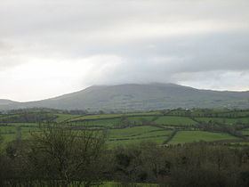
Slieve Croob (from Irish Sliabh Crúibe, meaning 'mountain of the hoof') is the tallest of a group of peaks in the middle of County Down, Northern Ireland. These peaks lie north of the Mourne Mountains, between the village of Dromara and the town of Castlewellan. Slieve Croob has been designated an Area of Outstanding Natural Beauty. It is the source of the River Lagan, which starts as a spring and runs from here, through Dromara, Dromore, County Down, Lisburn and Belfast, where it enters Belfast Lough.
Contents
Map of Slieve Croob, Castlewellan, UK
FolkloreEdit
Folklore tells that 12 kings are buried at the hilltop and each year it is traditional to climb Slieve Croob on the first Sunday in August (known as Cairn Sunday or Blaeburry Sunday) and carry with you a stone to help bury the kings. In recent times there is traditional Irish music played at the top of the Mountain on this date.
Places of interestEdit
CommunicationsEdit
A number of communications relay stations are located on the summit of Slieve Croob. They include communications towers for British Telecom, Vodafone, police & emergency services, and the government.