
Topo map OS Landranger 103 Prominence 395 m | OS grid SD804414 Elevation 557 m Listing Marilyn | |
 | ||
Similar Towneley Park, Gawthorpe Hall, Clitheroe Castle Museum, Longridge Fell, Pendle Heritage Centre | ||
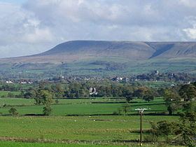
Pendle Hill is located in the east of Lancashire, England, near the towns of Burnley, Nelson, Colne, Clitheroe and Padiham. Its summit is 557 metres (1,827 ft) above mean sea level. It gives its name to the Borough of Pendle. It is an isolated hill, separated from the Pennines to the east, the Bowland Fells to the northwest, and the West Pennine Moors to the south. It is included in detached part of the Forest of Bowland Area of Outstanding Natural Beauty (AONB).
Contents
- Map of Pendle Hill Nelson UK
- TopographyEdit
- GeologyEdit
- HistoryEdit
- QuakersEdit
- Witches and the supernaturalEdit
- Four Hundred Years LaterEdit
- References
Map of Pendle Hill, Nelson, UK
TopographyEdit
Pendle Hill is separated from the nearby main bulk of the Bowland Fells by the River Ribble. This isolation means that Pendle Hill is in fact the most prominent child summit of Kinder Scout, far away in the Peak District, rather than a child of Ward's Stone, the highest point in Bowland.
GeologyEdit
The sloping plateau summit of Pendle Hill is formed from the Pendle Grit, a coarse Carboniferous age sandstone assigned to the Millstone Grit Group. It overlies a thick sequence of Carboniferous Limestone beds. In chronostratigraphy, the British sub-stage of the Carboniferous period, the 'Pendleian' derives its name from Pendle Hill where an exposure in Light Clough is taken as the type locality.
Much of the lower slopes are mantled by thick deposits of glacial till or boulder clay dating from the last Ice Age. The historic decomposition of sphagnum moss on the hill has led to it being covered in peat.
The steep slopes of its eastern and southern flanks have given rise to a series of landslips.
HistoryEdit
The name "Pendle Hill" combines the words for hill from three different languages (as does Bredon Hill in Worcestershire) In the 13th century it was called Pennul or Penhul, apparently from the Cumbric pen and Old English hyll, both meaning "hill". The modern English "hill" was appended later, after the original meaning of Pendle had become opaque.
A Bronze Age burial site has been discovered at the summit of the hill.
The hill is also famous for its links to three events which took place in the 17th century: the Pendle witch trials (1612), Richard Towneley's barometer experiment (1661), and the vision of George Fox (1652), which led to the foundation of the Religious Society of Friends (Quaker) movement.
The most popular route for ascending the hill begins in the village of Barley, which lies to the east. This route also provides the steepest ascent. Other nearby villages include Downham, Roughlee, Newchurch-in-Pendle, Sabden and Pendleton.
A local saying suggests the area around Pendle Hill experiences frequent rainfall: "If you can see Pendle it's about to rain, if you can't, it's already started." When the weather is fine Pendle is a popular hill-launch for paragliders and, with a north-westerly wind, for hang gliders.
QuakersEdit
In his autobiography, George Fox described a vision on Pendle Hill in 1652, during the early years of the Quakers:
As we travelled, we came near a very great hill, called Pendle Hill, and I was moved of the Lord to go up to the top of it; which I did with difficulty, it was so very steep and high. When I was come to the top, I saw the sea bordering upon Lancashire. From the top of this hill the Lord let me see in what places he had a great people to be gathered.
Today Pendle remains strongly linked to the Quakers, giving its name to one of their centres for religious and spiritual study and contemplation near Philadelphia, Pennsylvania, in the United States.
Witches and the supernaturalEdit
The story of the Pendle witches is a notorious and well-documented example of cases brought against alleged witches in 17th-century England. The hill continues to be associated with witchcraft; large numbers of visitors climb it every Halloween, although in recent years people have been discouraged by the authorities.
The area is popular with ghost hunters after Living channel's show Most Haunted visited it for a live investigation on Halloween 2004. The show's presenter, Yvette Fielding, said it was the scariest episode they had made.
Pendle Hill and the surrounding area are the setting for 1951's classic Mist Over Pendle by Robert Neill, and also for the fourth book in Joseph Delaney's The Wardstone Chronicles, called The Spook's Battle.
Four Hundred Years LaterEdit
On Saturday August 18th 2012, a total of 483 people amassed on Barley Green dressed as witches in order to commemorate the tragic events (The Witch Trials) of four hundred years earlier. The event was staged in order to raise funds for Pendleside Hospice, Burnley. The gathering of witches set a new World Record for the largest number of 'witches' assembled at one place.
Two sponsored walks were held on the day: both set off from Barley Green and meandered via Ings End to Pendle House. At this point the chain of walkers (some still dressed in their witches outfits) split into the two routes - those willing to take in the steep stepped route to the summit in the blazing sun and those preferring the less strenuous 'Under Pendle' route which flanks the eastern aspect of the hill. Both routes would then converge at Under Pendle and return to the village centre via the tarmac track also known as 'Barley Green'.