
Listing Hewitt, Nuttall OS grid NY223073 Prominence 57 m Parent range Southern Fells | Topo map OS Landrangers 89, 90 Elevation 935 m | |
 | ||
Similar Broad Crag, Scafell Pike, Great End, Esk Pike, Lingmell | ||
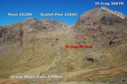
Ill Crag is a fell in the English Lake District. It is the fourth highest peak in England. Ill Crag overlooks Eskdale and has splendid views across to Bowfell and Crinkle Crags.
Contents
Map of Ill Crag, Seascale, UK
Topography
It forms part of the Scafell chain, and lies about 1 km east of Scafell Pike. Broad Crag lies immediately to the west, between Ill Crag and the Pike.
Ascents
Ill Crag may be climbed en route to Scafell Pike, via a path from Esk Hause, but it is commonly passed by without going to the actual summit, which is rocky making progress slow. Ill Crag's summit is a few hundred metres to the south of the path from Esk Hause to Scafell Pike.
References
Ill Crag Wikipedia(Text) CC BY-SA