
Basin size 7,431 km (2,869 sq mi) Discharge 47 m³/s Source Vosges | Length 246 km Basin area 7,431 km² | |
 | ||
Main source Vosges mountains±800 m (2,600 ft) Cities | ||
The Saar (French: Sarre; German: Saar) is a river in northeastern France and western Germany, and a right tributary of the Moselle. It rises in the Vosges mountains on the border of Alsace and Lorraine and flows northwards into the Moselle near Trier. It has two headstreams (the Sarre Rouge and Sarre Blanche, which join in Lorquin), that both start near Mont Donon, the highest peak of the northern Vosges. After 246 kilometres (153 mi) (126 kilometres in France and 120 kilometres in Germany) the Saar flows into the Moselle at Konz (Rhineland-Palatinate) between Trier and the Luxembourg border. It has a catchment area of 7,431 square kilometres (2,869 sq mi).
Contents
Map of Saar
The Saar was very important for the Saarland coal, iron and steel industries. Raw materials and finished products were shipped on it by water via the Canal des houillères de la Sarre, the Marne-Rhine Canal and the Rhine, for instance, to the Ruhr area or the port of Rotterdam.
Although the German part of the Saar has been upgraded to a waterway by deepening, construction of sluices and straightening, there is no significant shipping traffic.
The Saar flows through the following departments of France, states of Germany and towns:
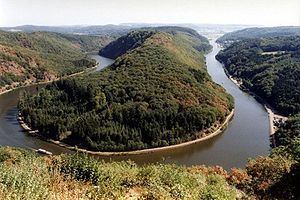
On the banks of the Saar is the UNESCO-World Heritage Site Völklinger Hütte. At Mettlach the Saar passes the well-known Saar loop. The lower Saar in Rhineland-Palatinate is a winegrowing region of some importance, producing mostly Riesling. Until the early 20th century, much more wine was grown on the banks of the Saar, reaching much further up from the mouth of the river, up to Saarbrücken. Only in the early 21st century have some enterprising farmers from the Saarland area started experimenting with winegrowing again.
The name Saar stems from the Celtic word sara (streaming water), and the Roman name of the river, saravus.