
Prominence 270 m (890 ft) Elevation 1,008 m Parent range Vosges | Location Bas-Rhin, France Mountain range Vosges | |
 | ||
Similar Rainkopf, Climont, Storkenkopf | ||
Mont Donon is the highest peak in the northern Vosges. It is a Category 2 climb in the Tour de France.
Contents
Map of Mont Donon, 67130 Grandfontaine, France
On Donon, there is an 80 metre tall lattice tower for TV transmission. Its TV transmission antennas are covered by a polymeric cylinder, which gives its structure a characteristic shape.
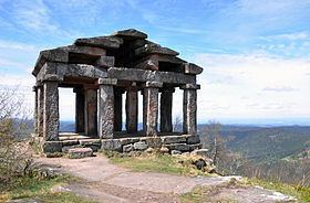
Many archaeological remains of a Gallo-Roman sanctuary have been found on and around the top of the mountain. They are now displayed in the Musée archéologique de Strasbourg.
World War I
During the earliest stages of World War I, Mount Donon was the site of heavy fighting between German and French troops between 14 August and 22 August 1914 and specially on 21 and 22 August.
References
Mont Donon Wikipedia(Text) CC BY-SA