
Country United States Incorporated 1854 Area 6,768 km² | Website www.countyofplumas.com Population 18,859 (2013) | |
 | ||
Time zone Pacific Standard Time (UTC-8) Destinations Points of interest | ||
Walker mine plumas county california
Plumas County is a county located in the Sierra Nevada of the U.S. state of California. As of the 2010 census, the population was 20,007. The county seat is Quincy, and the only incorporated city is Portola. The largest community in the county is East Quincy. The county gets its name from the Spanish words for the Feather River (Río de las Plumas), which flows through the county.
Contents
- Walker mine plumas county california
- Map of Plumas County CA USA
- History
- Geography
- Designated areas
- Adjacent counties
- National protected areas
- 2010
- 2000
- Law and government
- Overview
- Crime
- Culture
- Media
- Education
- Major highways
- Scenic byways
- Public transit
- Airports
- City
- Ghost towns
- Population ranking
- References
Map of Plumas County, CA, USA
History
Prior to the California Gold Rush of 1849, the Mountain Maidu were the primary inhabitants of the area now known as Plumas County. The Maidu lived in small settlements along the edges of valleys, subsisting on roots, acorns, grasses, seeds, and occasionally fish and big game. There was no official tribal leadership, and most groups remained in and around their own valleys. Areas with high snowfall, including Mohawk and Sierra Valleys, provided hunting grounds in the warmer months.
Life quickly changed for the Mountain Maidu, however, when gold was discovered in the Sierra foothills in 1848. Miners were attracted to Plumas County in particular largely due to the wild tales of a man named Thomas Stoddard, whose claims of stumbling onto a lake lined with gold nuggets while lost in the wilderness attracted gold hungry prospectors to the area. Though hopeful miners scoured the glacial lakes of what is now Lakes Basin Recreation Area for months, they could not find the alleged lake of gold. However, some of them did have success in the rivers and creeks in the area, which led to the development of many of Plumas County’s first non-Indian settlements.
Towns quickly sprung up around successful mining areas, including Rich Bar, Indian Bar, and Rabbit Creek (now La Porte). The Feather River, named by Spanish explorer Captain Luis Arguello as "Río de las Plumas" in 1820, was the site of many of these settlements.
Contributing to the wave of Euro-Americans entering the Plumas County area was African American frontiersman James Beckwourth’s discovery of the lowest pass through the Sierras, Beckwourth Pass, in 1850. Using the pass, he blazed a trail that began in Western Nevada and went through much of Plumas County, eventually terminating in the Sacramento Valley. He also set up a trading post in western Sierra Valley that still stands today. Though the Beckwourth Trail was longer than the original emigrant trail that ran south of Plumas County, its lower elevations kept it in heavy use until about 1865, when the railroads became the favored transportation method for westward-bound travelers.
Plumas County was formed in 1854 during a meeting of three commissioners held at the American Ranch in Quincy and was carved from the eastern portion of Butte County. Quincy, originally a mining town, was chosen as the county seat after a heated election against nearby Elizabethtown. A large portion Plumas County was taken to create Lassen County in 1864, and shortly afterward Plumas County annexed part of Sierra County, including the prosperous mining town of La Porte.
Over the next decades, different industries influenced the growth of the various settlements that sprung up around the county. Greenville began as a mining and farming community in Indian Valley in the late 1850s. Near the area that is now Lake Almanor, Chester was formed as a result of cattle ranching and the timber industry. When the Western Pacific Railroad was constructed in 1910, Portola sprung up as an important railroad stop. Thanks to the railroad, Plumas County could export its lumber beyond the local area, which allowed the timber industry to become the dominating force in the county’s economy. The railroad’s route up the Feather River Canyon also brought the area’s first tourists and sightseers. When the Feather River Highway was completed in 1937, Plumas County became linked to the Sacramento Valley year-round thanks to the route’s low elevation.
Geography
According to the U.S. Census Bureau, the county has a total area of 2,613 square miles (6,770 km2), of which 2,553 square miles (6,610 km2) is land and 60 square miles (160 km2) (2.3%) is water.
Plumas County is located in the far northern end of the Sierra Nevada range. The area's rugged terrain marks the transition point between the northern Sierra Nevadas and the southern end of the Cascade Range. Lassen Peak, which is the southernmost volcanic peak in the Cascade Range, is found just north of Plumas County's border, and part of Lassen Volcanic National Park extends into the northwest corner of the county.
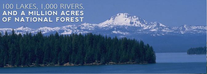
Plumas National Forest's 1,200,000 acres (4,900 km2) offer a wide variety of outdoor recreation opportunities, including hiking, camping, kayaking, swimming, mountain biking, hunting and fishing. The area features more than 100 natural and artificial lakes. Many of the natural lakes are glacial in origin and can be found in and around Lakes Basin Recreation Area. The artificial lakes include Lake Almanor, Lake Davis, Frenchman Lake, Little Grass Valley Reservoir, Antelope Lake, and Buck's Lake. Plumas County also features more than 1,000 miles of rivers and streams. All three forks of the Feather River run through the area.
Designated areas
Adjacent counties
National protected areas
2010
The 2010 United States Census reported that Plumas County had a population of 20,007. The racial makeup of Plumas County was 17,797 (89.0%) White, 192 (1.0%) African American, 539 (2.7%) Native American, 134 (0.7%) Asian, 18 (0.1%) Pacific Islander, 603 (3.0%) from other races, and 724 (3.6%) from two or more races. Hispanic or Latino of any race were 1,605 persons (8.0%).
2000
As of the census of 2000, there were 20,824 people, 9,000 households, and 6,047 families residing in the county. The population density was 8 people per square mile (3/km²). There were 13,386 housing units at an average density of 5 per square mile (2/km²). The racial makeup of the county was 91.8% White, 0.6% Black or African American, 2.6% Native American, 0.5% Asian, 0.1% Pacific Islander, 1.8% from other races, and 2.6% from two or more races. 5.7% of the population were Hispanic or Latino of any race. 16.1% were of German, 15.0% English, 10.1% Irish and 8.0% American ancestry according to Census 2000. 95.4% spoke English and 3.6% Spanish as their first language.
There were 9,000 households out of which 26.4% had children under the age of 18 living with them, 55.4% were married couples living together, 8.0% had a female householder with no husband present, and 32.8% were non-families. 27.5% of all households were made up of individuals and 10.1% had someone living alone who was 65 years of age or older. The average household size was 2.29 and the average family size was 2.77.
In the county, the population was spread out with 22.7% under the age of 18, 6.0% from 18 to 24, 22.6% from 25 to 44, 30.8% from 45 to 64, and 17.9% who were 65 years of age or older. The median age was 44 years. For every 100 females there were 99.8 males. For every 100 females age 18 and over, there were 97.9 males.
The median income for a household in the county was $36,351, and the median income for a family was $46,119. Males had a median income of $38,742 versus $25,734 for females. The per capita income for the county was $19,391. About 9.0% of families and 13.1% of the population were below the poverty line, including 16.7% of those under age 18 and 6.4% of those age 65 or over.
Law and government
Plumas County has five elected Supervisors, each elected within their own district. The Board of Supervisors oversees the management of county government and members serve four-year terms. The Clerk of the Board of Supervisors provides support to the Board of Supervisors and information to the public.
The purpose of the County Administrative Office is to facilitate the delivery of cost-effective county services in accordance with the vision and policies outlined by the Board of Supervisors. The responsibilities of the County Administrative Office include monitoring legislative affairs, preparing the county's annual budget, and undertaking studies and investigations for the Board of Supervisors.
The Sheriff is the chief law enforcement officer of the county. The jurisdiction of the Sheriff extends throughout the county, including federal and state lands. The County Sheriff is elected to the non-partisan office for a four-year term and is charged with preserving the peace, enforcing criminal statutes, and investigating known or suspected criminal activity.
More than three-quarters of Plumas County's 2,618 square miles (6,780 km2) is National Forest Service land. The management of Plumas National Forest is overseen by three districts: Beckwourth Ranger District, Mt. Hough Ranger District, and Feather River Ranger District.
Overview
In its early history Plumas was a reliable Republican county, voting for that party in every election from 1864 to 1908. Plumas then become one of the most reliably Democratic counties in California, voting for the Democratic candidate for President in thirteen straight elections from 1928 to 1976. The county has voted Republican in every presidential election since 1980, except for 1992 when Bill Clinton won a small plurality.
Plumas County is in California's 1st congressional district, represented by Republican Doug LaMalfa. At the state level, Plumas is in the 1st Senate District, represented by Republican Ted Gaines, and the 1st Assembly District, represented by Republican Brian Dahle.
Crime
The following table includes the number of incidents reported and the rate per 1,000 persons for each type of offense.
Culture
Media
The primary local news source since 1866 is Feather Publishing Co., Inc. at plumasnews.com. Four Plumas County newspapers are published every Wednesday, except for certain holidays. Plumas County is in the Sacramento television market. KXTV, News10, Sacramento and KCRA-3, Sacramento regularly cover major news events in Plumas County.
Education
Major highways
Scenic byways
The Feather River National Scenic Byway follows the Middle and North Forks of the Feather River, traversing steep canyon walls and high mountain valleys. The route features grasslands, oak woodlands, mixed conifer, and high desert chaparral. It begins in the Sacramento Valley, following the Feather River Canyon and entering Plumas County just west of Storrie. As it gains elevation, it climbs over the crest of the Sierra and passes through Quincy and Portola, eventually finding its way to the Middle Fork of the Feather River and following it to its headwaters in Sierra Valley. After going through Beckwourth Pass, the route terminates at Hallelujah Junction on Highway 395.
The southernmost point of the Volcanic Legacy Scenic Byway, Lake Almanor, is located in Plumas County. The route spans 500 miles between California and Oregon and offers spectacular views of dramatic volcanic landscapes, including nearby Lassen Peak.
The Scenic Byway Link refers to the section of Highway 89 that connects the Volcanic Legacy and Feather River Scenic Byways. Featuring the alpine meadows of Indian Valley, the rushing waters of Indian Creek, and the stunning views of Mt. Hough and the surrounding mountains, the route is about 18 miles long.
Public transit
Plumas Transit Systems, operated by the county, provides local service in Quincy and routes to Chester and Portola.
Airports
Gansner Field is a general aviation airport located near Quincy. Rogers Field is located near Chester; in addition to its civil-aviation role it also serves as the Chester Air Attack Base, a logistical & coordination facility for the California Department of Forestry's aerial firefighting (both fixed-wing and helicopter). Resources include fueling, retardant loading, communications, and some quartering for aircrew and ground fire-fighting teams. Nervino Airport is in Beckwourth, east of Portola.
City
Ghost towns
Population ranking
The population ranking of the following table is based on the 2010 census of Plumas County.
† county seat