
County Plumas FIPS code 06-59080 Elevation 1,046 m Zip code 95971 Area code 283 (530 Exchange) | State California Time zone Pacific (PST) (UTC-8) GNIS feature ID 265113 Area 10.98 km² Population 5,500 (2010) | |
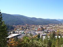 | ||
Quincy (formerly, Quinsy) is a census-designated place and the county seat of Plumas County, California.The population was 5,500 during the 2010 census, up from 4,500 during the 2000 United States Census.
Contents
- Map of Quincy CA 95971 USA
- History
- Geography and climate
- 2010
- 2000
- Annual cultural events
- Museums and other points of interest
- Government
- Notable people
- References
Map of Quincy, CA 95971, USA
History
Quincy started as a Gold Rush community just outside Elizabethtown, CA. Elizabethtown started in 1852 and slowly dissolved and moved a mile away into American Valley to form Quincy after 1858.
Quincy is named after the city of Quincy, Illinois, named in turn after John Quincy Adams (1767 - 1848), the sixth president of the United States (1825 - 1829).
The Quincy post office opened in 1855. James H. Bradley, one of the organizers of Plumas County, donated the land at Quincy for establishment of the county seat. He then laid out the town and named it after his ranch in Illinois.
Geography and climate
Quincy is located at 39°56′11″N 120°56′53″W (39.936279, -120.947921).
According to the United States Census Bureau, the CDP has a total area of 4.2 square miles (11 km2), all of it is land.
Quincy is underlain by metasedimentary rock of the Shoo Fly Complex. Its dominant silica-rich clastic material weathers to a stony coarse soil which includes the well or somewhat excessively drained alluvial fan material (mainly Forgay very gravelly sandy loam) on which most of Quincy's businesses and homes have been built. Cultivated land north of the residential area lies on poorly drained loam, silt loam or fine sandy loam.
Quincy has a Mediterranean climate (Köppen Csb) though its inland location and altitude makes it more continental and wetter than usual for this type, with very heavy snowfalls sometimes occurring in winter – the record being 133 inches (337.8 cm) in the very wet January 1916. Although summer days are hot and only 1.4 days per winter fail to top 32 °F (0 °C), nights can be very cold and frosts occur on 179 days per year and have been recorded even in July.
2010
The 2010 United States Census reported that Quincy had a population of 1,728. The population density was 407.6 people per square mile (157.4/km²). The racial makeup of Quincy was 1,500 (86.8%) White, Hispanic or Latino of any race were 132 persons (7.6%) 37 (2.1%) Black, 29 (1.7%) Native American, 19 (1.1%) Asian, 2 (0.1%) Pacific Islander, 66 (3.8%) from other races, and 75 (4.3%) from two or more races.
The Census reported that 1,673 people (96.8% of the population) lived in households, 0 (0%) lived in non-institutionalized group quarters, and 55 (3.2%) were institutionalized.
There were 798 households, out of which 183 (22.9%) had children under the age of 18 living in them, 300 (37.6%) were opposite-sex married couples living together, 85 (10.7%) had a female householder with no husband present, 28 (3.5%) had a male householder with no wife present. There were 63 (7.9%) unmarried opposite-sex partnerships, and 5 (0.6%) same-sex married couples or partnerships. 314 households (39.3%) were made up of individuals and 93 (11.7%) had someone living alone who was 65 years of age or older. The average household size was 2.10. There were 413 families (51.8% of all households); the average family size was 2.77.
The population was spread out with 341 people (19.7%) under the age of 18, 163 people (9.4%) aged 18 to 24, 350 people (20.3%) aged 25 to 44, 556 people (32.2%) aged 45 to 64, and 318 people (18.4%) who were 65 years of age or older. The median age was 45.5 years. For every 100 females there were 84.2 males. For every 100 females age 18 and over, there were 81.1 males.
There were 872 housing units at an average density of 205.7 per square mile (79.4/km²), of which 388 (48.6%) were owner-occupied, and 410 (51.4%) were occupied by renters. The homeowner vacancy rate was 2.7%; the rental vacancy rate was 5.5%. 872 people (50.5% of the population) lived in owner-occupied housing units and 801 people (46.4%) lived in rental housing units.
2000
As of the census of 2000, there were 1,879 people, 858 households, and 479 families residing in the CDP. The population density was 443.4 people per square mile (171.1/km²). There were 899 housing units at an average density of 212.2 per square mile (81.9/km²). The racial makeup of the CDP was 90.9% White, 1.5% African American, 2.2% Native American, 0.8% Asian, 0.1% Pacific Islander, 1.5% from other races, and 3.0% from two or more races. Hispanic or Latino of any race were 4.8% of the population.
There were 858 households out of which 27.3% had children under the age of 18 living with them, 40.2% were married couples living together, 12.7% had a female householder with no husband present, and 44.1% were non-families. 38.7% of all households were made up of individuals and 13.8% had someone living alone who was 65 years of age or older. The average household size was 2.13 and the average family size was 2.79.
In the CDP, the population was spread out with 23.9% under the age of 18, 8.6% from 18 to 24, 24.3% from 25 to 44, 25.8% from 45 to 64, and 17.4% who were 65 years of age or older. The median age was 41 years. For every 100 females there were 89.2 males. For every 100 females age 18 and over, there were 87.2 males.
The median income for a household in the CDP was $30,508, and the median income for a family was $40,536. Males had a median income of $38,438 versus $27,411 for females. The per capita income for the CDP was $19,944. About 5.1% of families and 11.1% of the population were below the poverty line, including 11.3% of those under age 18 and 2.8% of those age 65 or over.
Annual cultural events
The town has been the home of the High Sierra Music Festival since 2000.
Sparkle is an annual, small town get together, where town folk get together and celebrate the changing of the season, from Thanksgiving to Christmas. It occurs on the first Friday every December. Many folk celebrate by participating in a communal heroic dosing of homegrown love and kinship, and silly simon.
Museums and other points of interest
Quincy contains the Plumas County Museum, which houses Maidu Indian and Gold Rush artifacts as well as many other items.
Government
In the California State Legislature, Quincy is in the 1st Senate District, represented by Republican Ted Gaines, and in the 1st Assembly District, represented by Republican Brian Dahle.
Federally, Quincy is in California's 1st congressional district, represented by Republican Doug LaMalfa.