
Country United States Region Sacramento Valley Highest elevation 4,828 ft (1,472 m) Population 73,340 (2013) Unemployment rate 9.2% (Apr 2015) | State California Incorporated February 18, 1850 Area 1,668 km² County seat Marysville | |
 | ||
CSA Sacramento–Arden-Arcade–Yuba City Colleges and Universities Yuba College, Yuba Community College District Rivers Feather River, Bear River, Yuba River, Honcut Creek Destinations Marysville, California 49, Wheatland, Plumas National Forest, New Bullards Bar Rese | ||
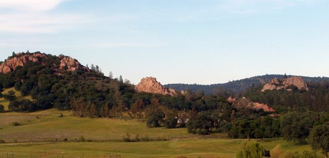
Northern california estate timbuctoo sporting estate yuba county california
Yuba County is a county located in the U.S. state of California. As of the 2010 census, the population was 72,155. The county seat is Marysville.
Contents
- Northern california estate timbuctoo sporting estate yuba county california
- Map of Yuba County CA USA
- History
- Geography
- Ecology
- Crime
- Overview
- Major highways
- Public transportation
- Airports
- 2010
- 2000
- Education
- Cities
- Population ranking
- References
Map of Yuba County, CA, USA
Yuba County is included in the Yuba City, CA Metropolitan Statistical Area, which is also included in the Sacramento-Roseville, CA Combined Statistical Area. The county is located in California's Central Valley along the Feather River.
History
Yuba County was one of the original counties of California, formed in 1850 at the time of statehood. Parts of the county's territory were given to Placer County in 1851, to Nevada County in 1851 and to Sierra County in 1852.
The county was named after the Yuba River by Captain John Sutter for the Native American village Yubu, Yupu or Juba near the confluence of the Yuba and Feather rivers. General Mariano Vallejo stated that the river was named Uba by an exploring expedition in 1824 because of the quantities of wild grapes (uvas silvestres in Spanish) which they found growing on its banks.
Geography
According to the U.S. Census Bureau, the county has a total area of 644 square miles (1,670 km2), of which 632 square miles (1,640 km2) is land and 12 square miles (31 km2) (1.9%) is water. It is the fifth-smallest county in California by total area. The county lies along the western slope of the Sierra Nevada, the steep slopes making it prime territory for the siting of hydroelectric power plants.
A portion of the county, where Marysville (the county seat) and most of the population lives, is west of the mountains on the valley floor. There is a great deal of agriculture business in this part of the county, especially fruit orchards, rice fields, and cattle grazing.
Ecology
National protected areas within Yuba County include portions of the Plumas National Forest and the Tahoe National Forest. In addition to these identified protected areas the county has extensive natural areas consisting of forestation, grassland, riparian area, grassland and other habitats. The county exhibits a considerable diversity of flowering plant species, among which is the yellow mariposa lily, Calochortus luteus.
Crime
The following table includes the number of incidents reported and the rate per 1,000 persons for each type of offense.
Overview
Yuba is a strongly Republican county in Presidential and congressional elections. The last Democrat to win a majority in the county was Jimmy Carter in 1976.
In the United States House of Representatives, Yuba County is in California's 3rd congressional district, represented by Democrat John Garamendi.
In the California State Legislature, the county is in the 4th Senate District, represented by Republican Jim Nielsen, and the 3rd Assembly District, represented by Republican James Gallagher.
Major highways
Public transportation
Yuba Sutter Transit operates local bus service, as well as commuter runs to Downtown Sacramento. Greyhound buses stop in Marysville.
Airports
Yuba County Airport is located three miles (5 km) south of Marysville. It is a general aviation airport.
Brownsville Aero Pines Airport is located off La Porte Rd in Brownsville.
2010
The 2010 United States Census reported that Yuba County had a population of 72,155. The racial makeup of Yuba County was 49,332 (68.4%) White, 2,361 (3.3%) African American, 1,675 (2.3%) Native American, 4,862 (6.7%) Asian, 293 (0.4%) Pacific Islander, 8,545 (11.8%) from other races, and 5,087 (7.1%) from two or more races. Hispanic or Latino of any race were 18,051 persons (25.0%).
2000
As of the census of 2000, there were 60,219 people, 20,535 households, and 14,805 families residing in the county. The population density was 96 people per square mile (37/km²). There were 22,636 housing units at an average density of 36 per square mile (14/km²). The racial makeup of the county was 70.6% White, 3.2% Black or African American, 2.6% Native American, 7.5% Asian, 0.2% Pacific Islander, 10.0% from other races, and 5.9% from two or more races. 17.4% of the population were Hispanic or Latino of any race. 11.2% were of German, 10.4% American, 7.6% Irish and 7.5% English ancestry according to Census 2000. 78.8% spoke English, 13.2% Spanish and 4.7% Hmong as their first language.
There were 20,535 households out of which 38.1% had children under the age of 18 living with them, 53.2% were married couples living together, 13.3% had a female householder with no husband present, and 27.9% were non-families. 21.7% of all households were made up of individuals and 8.2% had someone living alone who was 65 years of age or older. The average household size was 2.87 and the average family size was 3.34.
In the county, the population was spread out with 31.0% under the age of 18, 10.7% from 18 to 24, 28.0% from 25 to 44, 19.6% from 45 to 64, and 10.6% who were 65 years of age or older. The median age was 31 years. For every 100 females there were 101.6 males. For every 100 females age 18 and over, there were 99.4 males.
The median income for a household in the county was $30,460, and the median income for a family was $34,103. Males had a median income of $27,845 versus $21,301 for females. The per capita income for the county was $14,124. About 16.3% of families and 20.8% of the population were below the poverty line, including 27.6% of those under age 18 and 7.8% of those age 65 or over.
Education
Higher education is available at the county's Junior College, Yuba Community College. The county also has a Yuba County Library system with one branch in Marysville.
Yuba County schools have a 16% suspension rate with 2257 students receiving suspensions out of 14027 students enrolled in Yuba County schools.
Cities
Population ranking
The population ranking of the following table is based on the 2010 census of Yuba County.
† county seat