
Country United States Population 428,826 (2013) | Incorporated February 18, 1850 Area 9,767 km² Unemployment rate 7.6% (Apr 2015) | |
 | ||
Colleges and Universities California State University, Monterey Peninsula College, Hartnell College, Defense Language Institute, Naval Postgraduate School Points of interest Monterey Bay Aquarium, Fisherman's Wharf - Monterey, Cannery Row, National Steinbeck Center, Mazda Raceway Laguna S | ||
Monterey County is a county located on the Pacific coast of the U.S. state of California. As of the 2010 census, the population was 415,057. The county seat and largest city is Salinas.
Contents
- Map of Monterey County CA USA
- History
- Geography
- National protected areas
- Flora and fauna
- Income Education and Poverty 2013
- Most affluent neighborhoods
- Least affluent neighborhoods
- 2010
- 2000
- Government
- Supervisorial Districts
- District 1
- District 2
- District 3
- District 4
- District 5
- State and federal Representatives
- Overview
- Crime
- Media
- Home prices
- Major highways
- Public transportation
- Airports
- Other places
- Population ranking
- References
Map of Monterey County, CA, USA
Monterey County comprises the Salinas, CA Metropolitan Statistical Area. It borders the Monterey Bay. The northern half of the bay is in Santa Cruz County. Monterey County is a member of the regional governmental agency, Association of Monterey Bay Area Governments.
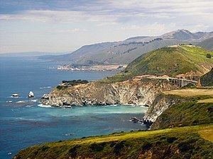
The coastline, including Big Sur, State Route 1, and the 17 Mile Drive on the Monterey Peninsula, has made the county world-famous. The city of Monterey was the capital of California under Spanish and Mexican rule. The economy is primarily based upon tourism in the coastal regions and agriculture in the Salinas River valley. Most of the county's people live near the northern coast and Salinas Valley, while the southern coast and inland mountain regions are sparsely populated.
History
Monterey County was one of the original counties of California, created in 1850 at the time of statehood. Parts of the county were given to San Benito County in 1874. The area was originally populated by Ohlone, Salinan & Esselen tribes.
The county derived its name from Monterey Bay. The bay was named by Sebastián Vizcaíno in 1602 in honor of the Conde de Monterrey (or Count of Monterrey), then the Viceroy of New Spain. Monterrey is a variation of Monterrei, a municipality in the Galicia region of Spain where the Conde de Monterrey and his father (the Fourth Count of Monterrei) were from.
Geography
According to the U.S. Census Bureau, the county has a total area of 3,771 square miles (9,770 km2), of which 3,281 square miles (8,500 km2) is land and 491 square miles (1,270 km2) (13%) is water. The county is roughly 1.5 times larger than the state of Delaware, and roughly similar in population and size to Santa Barbara County.
National protected areas
Flora and fauna
Monterey County has habitat to support the following endangered species:
Income, Education and Poverty 2013
Generally, the western/southern parts of the Monterey Peninsula, Carmel Valley, Creekbridge (Salinas), and eastern parts of Prundale were the county's most affluent and educated (see dark blue on map). These areas had a median household income significantly above that of the California or the U.S. overall (typically above $95,000 vs. $60,000 for California and $52,000 for the U.S.) and comprised roughly 8%-10% of neighorhoods (as defined by Census Block Groups). Educational attainment was at least on part with, or above, state and national levels, in these areas while the percentage of people living in poverty was typically a third or less than national and statewide average (with the exception of South Salinas).
Social deprivation (poverty and low levels of educational attainment) was concentrated in the central and eastern parts of Salinas, and central areas of Monterey, Seaside, Marina, Soledad and King City. In central and eastern Salinas up to 46% of individuals lived below the poverty line and those without a secondary educations formed a plurality or majority of residents. Overall, the Salinas metropolitan area, defined as coterminous with Monterey County, was among the least educated urban areas in the nation.
Most affluent neighborhoods
Roughly 8% of neighborhoods, as defined by Census Block Groups, had a median household income above $100,000 per year, about 60% above the national median. This coincided with the top 20 census block groups in the county listed below.
Most affluent neighborhoods (Median Household Income above $100k/yr.)
* Asterisk denotes a hypothetical rank among Monterey County's 226 Census Block Groups (e.g. if the U.S. overall was a Census Block Group in Monterey County, it would be the 141st most affluent of 226).
Least affluent neighborhoods
About 4.5% of neighborhoods, as defined by Census Block Groups, had a median household income below $30,000 per year, about 60% below the national median. This coincided with the 10 poorest of the 20 lowest income neighborhoods listed in the table below.
Least affluent neighborhoods (Median Household Income of $34.1k or less)
* Asterisk denotes a hypothetical rank among Monterey County's 226 Census Block Groups (e.g. if the U.S. overall was a Census Block Group in Monterey County, it would be the 86th poorest of 226).
2010
The 2010 United States Census reported that Monterey County had a population of 415,057. The racial makeup of Monterey County was 230,717 (55.6%) White, 12,785 (3.1%) African American, 5,464 (1.3%) Native American, 25,258 (6.1%) Asian (2.8% Filipino, 0.7% Korean, 0.6% Chinese, 0.6% Japanese, 0.4% Vietnamese, 0.4% Indian), 2,071 (0.5%) Pacific Islander, 117,405 (28.3%) from other races, and 21,357 (5.1%) from two or more races. Hispanic or Latino of any race were 230,003 persons (55.4%); 50.2% of Monterey County is Mexican, 0.8% Salvadoran, and 0.5% Puerto Rican.
2000
As of the census of 2000, there were 401,762 people, 121,236 households, and 87,896 families residing in the county. The population density was 121 people per square mile (47/km²). There were 131,708 housing units at an average density of 40 per square mile (15/km²). The racial makeup of the county was 55.9% White, 3.8% Black or African American, 1.1% Native American, 6.0% Asian, 0.5% Pacific Islander, 27.8% from other races, and 5.0% from two or more races. 46.79% of the population were Hispanic or Latino of any race. 6.3% were of German and 5.4% English ancestry according to Census 2000. 52.9% spoke English, 39.6% Spanish and 1.6% Tagalog as their first language.
There were 121,236 households out of which 39.1% had children under the age of 18 living with them, 56.0% were married couples living together, 11.6% had a female householder with no husband present, and 27.5% were non-families. 21.2% of all households were made up of individuals and 8.2% had someone living alone who was 65 years of age or older. The average household size was 3.14 and the average family size was 3.65.
In the county, the population was spread out with 28.4% under the age of 18, 10.9% from 18 to 24, 31.4% from 25 to 44, 19.3% from 45 to 64, and 10.0% who were 65 years of age or older. The median age was 32 years. For every 100 female residents there were 107.3 male residents. For every 100 female residents age 18 and over, there were 107.7 male residents.
The median income for a household in the county was $48,305, and the median income for a family was $51,169. Men had a median income of $38,444 versus $30,036 for women. The per capita income for the county was $20,165. About 9.7% of families and 13.5% of the population were below the poverty line, including 17.4% of those under age 18 and 6.8% of those age 65 or over.
Government
At the local level, Monterey County is governed by the Monterey County Board of Supervisors. Like all governing bodies in California, the Monterey County Board of Supervisors is empowered with both legislative and executive authority over the entirety of Monterey County and is the primary governing body for all unincorporated areas within the County boundaries. The Board has five elected members, each of whom represents one of five districts. Taken together, the five districts comprise the entirety of the county.
Current board members:
The Board conducts its meetings in the county seat, Salinas, and is a member of the regional governmental agency, the Association of Monterey Bay Area Governments.
Supervisorial Districts
Supervisorial district boundaries are divided roughly equally according to population, using data from the most recent census. In addition, any redistricting changes must comply with both California law as well as the federal Voting Rights Act. Boundaries are adjusted decennially based on data reported by the United States Census Bureau for the most recent census.
District 1
The 1st District is geographically the smallest supervisorial district in Monterey County and is entirely within the city limits of the city of Salinas.
Fernando Armenta represents the 1st District on the Board of Supervisors. His current term expires in January, 2017.
District 2
As the northernmost supervisorial district in Monterey County, the 2nd District includes the communities of Boronda, Castroville, Las Lomas, Moss Landing, Pajaro, Prunedale, Royal Oaks, the northern neighborhoods of the city of Salinas, and those portions of the community of Aromas that are located within Monterey County.
John Phillips is currently the Supervisor for the 2nd District. His current term ends in January, 2019.
District 3
The 3rd District covers the majority of the Salinas Valley and southern Monterey County, extending to its border with San Luis Obispo County. The district includes the unincorporated communities of Spreckels, Chualar, and Jolon; the eastern portion of the city of Salinas; the cities of Gonzales, Greenfield, Soledad, and King City; the military installations at Fort Hunter Liggett and Camp Roberts; and portions of the Los Padres National Forest.
The 3rd District is represented by Simon Salinas. His current term ends in January, 2015.
District 4
The 4th District includes the southwest portion of the city of Salinas, the cities of Del Rey Oaks, Marina, Seaside, Sand City, and the former military installation at Fort Ord.
Jane Parker currently holds the seat for 4th District Supervisor. Her current term ends in January, 2013. However, having won reelection in June 2012, Parker's next term will extend until January, 2017.
District 5
The 5th District is geographically the largest of the five supervisorial districts, and covers most of the Monterey Peninsula and southern coastline of Monterey County down to the southern county border with San Luis Obispo County. The 5th District includes the cities of Carmel-by-the-Sea, Monterey, and Pacific Grove; the unincorporated communities of Carmel Valley, Big Sur, Pebble Beach, San Benancio, Corral de Tierra, and Jamesburg; military installations at the Presidio of Monterey, the Defense Language Institute, and the Naval Postgraduate School; and the Ventana Wilderness area of the Los Padres National Forest.
Dave Potter is currently the 5th District Supervisor. His current term ends in January, 2013.
State and federal Representatives
In the United States House of Representatives, Monterey County is part of California's 20th congressional district, represented by Democrat Jimmy Panetta.
In the California State Assembly, Monterey County is split between the 29th Assembly District, represented by Democrat Mark Stone, and the 30th Assembly District, represented by Democrat Anna Caballero.
In the California State Senate, Monterey County is split between the 12th Senate District, represented by Republican Anthony Cannella, and the 17th Senate District, represented by Democrat Bill Monning.
Overview
Monterey County is considered to be a strongly Democratic county in Presidential and congressional elections. The county voted for Al Gore in 2000, John Kerry in 2004 and Barack Obama in the 2008 election. The last Republican to win the county was George H.W. Bush in 1988.
According to the California Secretary of State, as of April, 2008, Monterey County has 147,066 registered voters. Of those voters, 72,550 (49.3%) are registered Democratic, 42,744 (29.1%) are registered Republican, 5,488 (3.7%) are registered with other political parties, and 26,284 (17.9%) declined to state a political party. Except for Sand City, all of the other cities, towns, and the unincorporated area of Monterey County have more individuals registered with the Democratic Party than the Republican Party. In Sand City, the Republicans have the advantage by 1 voter.
On Nov. 4, 2008 Monterey County voted 51.7% against Proposition 8 which amended the California Constitution to ban same-sex marriages.
Monterey County was subject to Section 5 of the Voting Rights Act which required federal preclearance before implementing a change to "any voting qualification or prerequisite to voting," before Section 5 was declared unconstitutional in the Supreme Court of the United States decision Shelby County v. Holder.
Crime
The following table includes the number of incidents reported and the rate per 1,000 persons for each type of offense.
Media
Television service for the community comes from the Monterey-Salinas-Santa Cruz designated market area (DMA). Radio stations Monterey-Salinas-Santa Cruz area of dominant influence (ADI) or continuous measurement market (CMM). Local newspapers include the Monterey County Herald, Monterey County Weekly, Salinas Californian and the Carmel Pine Cone.
Home prices
As of December 2005, Monterey County ranked among America's ten most expensive counties, with Santa Barbara County topping the list with a median home price of $753,790. In Monterey County, the median home price was $699,900. In the northern, more densely populated part in the county, the median home price was even higher, at $712,500, making it the fourth most expensive housing market in California. The disparity between the median household income of roughly $48,305 and the median home price of $700k has been cause for recent concern over excluding potential home buyers from the market. The end of the United States housing bubble has caused prices to drop substantially, with median home prices having fallen to $280,000 as at September 2008.
Major highways
Public transportation
Monterey County is served by Amtrak trains and Greyhound Lines buses. Monterey-Salinas Transit provides transit service throughout most of Monterey County, with buses to Big Sur and King City as well as in Monterey, Salinas and Carmel. MST also runs service to San Jose, California in Santa Clara County
Airports
Other places
Population ranking
The population ranking of the following table is based on the 2010 census of Monterey County.
† county seat