
Time zone PST (UTC-8) Elevation 7 m Zip code 95012 Area code Area code 831 | Founded 1863 FIPS code 06-11978 Area 2.737 km² Population 6,481 (2010) | |
 | ||
Castroville is a census-designated place (CDP) in Monterey County, California, United States. At the time of the 2010 census the population was 6,481.
Contents
- Map of Castroville CA USA
- Rancho Bolsa Nueva y Moro Cojo
- Castroville 1800
- Castroville Argus Newspaper
- Chinatown
- First artichoke
- Mrs Sally DeSante Hebert 1st Artichoke Queen
- Marilyn Monroe Honorary Artichoke Queen
- Local government
- Geography
- Climate
- 2010
- 2000
- Highway access
- References
Map of Castroville, CA, USA
The site of the community was originally part of Rancho Bolsa Nueva y Moro Cojo, a 30,901-acre (125.05 km2) Mexican land grant given in 1844 by Manuel Micheltorena, Governor of Alta California, to María Antonia Pico de Castro. After the 1848 cession of California to the United States following the Mexican-American War, Juan Bautista Castro, son of María Antonia Pico de Castro, founded Castroville in 1863.
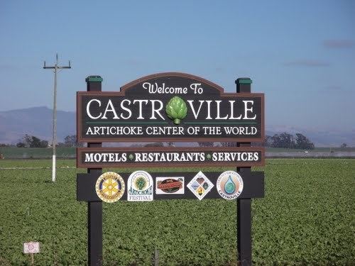
Castroville is known for its artichoke crop and for the annual Castroville Artichoke Festival, leading to its nickname as the "Artichoke Center of the World".
Rancho Bolsa Nueva y Moro Cojo
Rancho Bolsa Nueva y Moro Cojo was a 30,901 acre Mexican land grant given in 1844 by Governor Manuel Micheltorena to Maria Antonia Pico de Castro (Juan Bautista Castro's Mother.)
The Rancho Bolsa Nueva y Moro Cojo is a combination of three land grants. "Rancho Moro Cojo," granted by Governor Luis Antonio Arguello in 1825. The second is "Rancho Bolsa Nueva," by Governnor Mariano Chico in 1836. The third was granted by Governor Juan Alvarado to Simeon Castro (Juan Bautista Castro's Father) in 1837.
Lake Merritt and the sloughs were popular for fishing and hunting. The area around Castroville was crisscrossed by a network of sloughs and swamps.
In the 1840s, mapmaker Duflot de Mofras, wrote, "A few leagues before reaching the "Pajaro River", an area measuring a few hundred meters where the round trembles under the horses feet, although the earth is hard and covered by turf, is encountered.
The land is probably formed by a solid crust superimposed on a vast miry base."
Castroville, 1800+
Lots were divided into 50 by 130 feet, an alley ran through each block. A lottery was established and 100 lots were given away to any person who would clear land and build homes.
In 1870 Manuel R. Merritt, the editor of the newspaper Castroville Argus (1869–1880) announced, “We will give alternate lots, on any part of the town site we still own… to any person who will build as practicable, a good comfortable dwelling house on his lot.
Juan Bautista Castro would run for county supervisor for the district. Castro, Merritt, Geil and others traveled to the oldest settlement of Sotoville in Salinas, that is where the Indians and Paisanos lived. They packed their belongings, it was said Castro packed the tortilla cast iron pans, personal items and moved the people to Juan Pomber's hotel for ninety days.
They were registered and became ready to vote. They were not able to read in English, so the ballets were translated for them.
Juan Bautista Castro won the office of supervisor of his district. Juan Pomber became Road- Master of the district. The county supplied money and low income housing was built on the donated lots. Castroville now had residents and a community.
In 1875 Castroville had 900 residents. There were two hotels, five stores, stables, three saloons, flour mill, two blacksmith shops, newspaper (Castroville Argus), post office, telegraph office, drug store, tailor shop, shoe-maker, two churches, a school house, tin shop, and a brewery.
The Southern Pacific Railroad began extending the line south from Gilroy. Juan Bautista Castro had ambitions of Castroville becoming the new Station Freight Depot. Castroville's asking price for the land was high. Salinas offered the land for free, and was selected over Castroville.
Castroville was still considered an important stop, serving as the "point of juncture of the road from Monterey, and from Soledad to San Francisco." The first roundhouse was built here in Castroville.
Castroville Argus Newspaper
Established in July 17, 1869. The publishers were Juan Bautista Castro and Joseph R. Merritt.
Editors were Manuel R. Merritt (nephew of Juan Bautista Castro) and S.F. Geil. The office was in the Hicks Building (hardware store, later turned into school house, La Scuola) on the corner of Merritt and Poole Streets. It was a weekly paper and a new edition was available every Saturday.
Joseph Merritt (Publisher of the Castroville Argus) was born April 19, 1851. He was publisher for the Monterey Democrat and the Castroville Argus. In 1882 he was editor of the San Jose Mercury. 1884 he was on the editorial staff of the San Jose Daily Herald. He married Annie Phillips in 1872. He died at the age of 36.
Manuel R. Merritt (Editor of the Castroville Argus) was born June 8, 1855. He was the editor of the Castroville Argus, Castroville Gazette, and the Monterey County Herald. 1878 he was in the mercantile business, elected supervisor of Monterey County from the First District. Four times was a Delegate to the Democratic State Convention. He served as Secretary for the Democratic County Committee as well as serving as chairmen. He became Postmaster and Justice of the Peace. Real estate and insurance business. He died at the age of 48 from an accidental gunshot wound.
Chinatown
"In 1860 the Chinese contractors had established a presence here in Castroville. They were instrumental in clearing the slough, wetlands, and marshes especially in the northern section of the Rancho Bolsa Nueva y Moro Cojo. The land was ready to grow crops.
In 1878 Manteufel moved the Chinese businesses that were on Merritt Street to the corner of McDougall and Speegle Street. In 1883 a fire destroyed the entire Chinatown.
Chinatown was rebuilt and once again filled the sections of McDougall between Sanchez St. and Speegle St.
"The new gold rush, applying to agriculture was termed, "Sugar Beet Rush." With additional farms and more people, local businesses were successful. The Monterey County Assessor listed fifteen Chinese companies farming sugar beets in the area of Castroville.
The sugar beets farms continued to multiply and grow towards Salinas. The Chinese population in Castroville continue to grow as well. In 1891 Sam Kee and Jim Lee purchased a lot in Castroville. The "Quong Chung Company" purchased another lot. "This was the first time any Chinese had purchased property in the Monterey Bay Area."
In 1893 Salinas's Chinatown was destroyed. Many Chinese contractors and business owners moved to Castroville. When Watsonville's Chinatown burned down, the contractors also moved to Castroville.
The California Alien Land Law of 1913 was passed. It prohibited aliens ineligible for citizenship from owning agricultural land or possessing long-term leases over it. It affected the Chinese, Indian, Japanese, and Korean immigrant farmers in California.
The new law was meant to discourage immigration. It created an inhospitable environment among contractors working here in the Monterey Bay Area. Letters from the editorial section had cartoons of anti-Chinese sentiment. A small group of business owners proposed an economic boycott of all businesses that employed Chinese directly or indirectly.
Watsonville's farmers/landowners would not be intimidated. They would not be pressured to act un-American. The Chinese contractors made many contributions to the area, especially in the agriculture, railroad, and fishing industry. Without the Chinese contractors the agricultural industry would be in ruin.
The Chinese contractors began to leave the Monterey Bay Area. Some moved to San Francisco's Chinatown."
First artichoke
It was the Spanish settlers who brought the artichoke to California. Some artichoke plants were in the gardens of European immigrants.
California's first artichoke fields grew south of San Francisco, near the town of Half Moon Bay, in the early 1920s.
In 1922, Andrew Molera planted the first artichoke shoots in Castroville. Angelo Del Chiaro, Egidio Maracci, Daneil Pieri, and Amerigo Del Chiaro subsequently leased 150 acres of land and grew artichokes.
In 1923, there were nine artichoke growers. Within four years, there were over 50 growers and 12,000 acres of artichokes growing in Castroville, and in the Monterey Bay area.
In 1924 Daniel Pieri, Amerigo Del Chiaro, Angelo Del Chiaro, Alfred Tottino, and James Bellone formed the "California Artichoke and Vegetable Growers Corporation." In 1995, they renamed the company to "Ocean Mist Farms."
Mrs. Sally DeSante Hebert, 1st Artichoke Queen
Castroville's first Artichoke Queen was Mrs. Sally DeSante Hebert (1941–2004) crowned in 1961.
Mrs. Hebert was born in Carmel and grew up in Castroville. She moved to Salinas, graduated from Salinas High School, and Hartnell College.
She worked for Monterey County in the Planning Department, and was involved in the Junior League, Buena Vista Garden Club, American Cancer Society, and other civic-minded organizations.
Mrs. Sally DeSante Hebert raised a family with her husband Mr. Mike Hebert.
Marilyn Monroe, Honorary Artichoke Queen
Marilyn Monroe was given the honorary title of Artichoke Queen in 1947 during a visit to the Monterey Bay Area.
Stanley Seedman, owner of Carlyle's Jewelers in Salinas, California, made arrangements for a model named Doreen Nash to model for a big promotional sale in Salinas in February 1948. Doreen Nash was not able to attend; her replacement was Marilyn Monroe.
Marilyn Monroe spent a week in the Monterey Bay Area, visiting and promoting her career. She made her appearance replacing Doreen Nash at Carlyle's Jewelry and signed autographs. Marilyn Monroe was asked to draw the lucky ticket for a $250.00 diamond ring in the Vogue Theater.
During her stay in Salinas, Marilyn Monroe visited several Men's Civic Clubs including the Kiwanis Club. During the Kiwanis Club meeting, representatives from CalChoke (The California Artichoke Association) presented her with a sash.
A photograph was taken of her wearing a sash with the wording "California Artichoke Queen," and she posed with Edward Modena, Randy Barsotti, and Enrico Bellone. They were all holding artichokes."
The photographs of Marilyn wearing the sash and holding artichokes were used in advertisements and passed throughout the produce industry.
Local government
The Castroville Water District was founded in 1952 to replace private wells. The Castroville Community Service Area (providing storm sewer, sanitation sewers, street maintenance and recreational services) was created in 1962. The two merged in 2008. At the time of the merger, the Castroville CSA included North Monterey County High School and Moro Cojo, a subdivision in Prunedale which receives separate water service.
Geography
Coordinates: 36°45′57″N 121°45′29″W
Elkhorn Slough National Estuarine Research Reserve is northeast of Castroville. Established in 1983.
Moro Cojo Slough State Marine Reserve" is directly south of the "Elkhorn Slough." Established in 2007.
"Salinas River National Wildlife Refuge" is south of Castroville. It is the area where the Salinas River empties into the Monterey Bay. Established in 1974.
Santa Cruz, CA is 31 miles north of Castroville.
Salinas, CA is 14 miles south of Castroville.
Climate
Based on Köppen climate classification, Castroville has a cool-summer Mediterranean climate (Csb) and several microclimates, resulting in mild winters and cool summers.
There is no official wet season or dry season. Precipitation is dispersed throughout the year with most of it coming from various types of fog. One variation of is San Francisco fog (also known as advection fog) which mainly occurs along the Central Coast, from San Francisco to Santa Barbara.
2010
The 2010 United States Census reported that Castroville had a population of 6,481. The population density was 6,133.7 people per square mile (2,368.2/km²). The racial makeup of Castroville was 2,807 Hispanic or Latino of any race were 5,841 persons (90.1%)(43.3%) White, 96 (1.5%) African American, 96 (1.5%) Native American, 169 (2.6%) Asian, 9 (0.1%) Pacific Islander, 2,955 (45.6%) from other races, and 349 (5.4%) from two or more races. .
The Census reported that 6,467 people (99.8% of the population) lived in households, 14 (0.2%) lived in non-institutionalized group quarters, and 0 (0%) were institutionalized.
There were 1,470 households, out of which 931 (63.3%) had children under the age of 18 living in them, 866 (58.9%) were opposite-sex married couples living together, 273 (18.6%) had a female householder with no husband present, 161 (11.0%) had a male householder with no wife present. There were 140 (9.5%) unmarried opposite-sex partnerships, and 11 (0.7%) same-sex married couples or partnerships. 124 households (8.4%) were made up of individuals and 39 (2.7%) had someone living alone who was 65 years of age or older. The average household size was 4.40. There were 1,300 families (88.4% of all households); the average family size was 4.44.
The population was spread out with 2,169 people (33.5%) under the age of 18, 888 people (13.7%) aged 18 to 24, 1,876 people (28.9%) aged 25 to 44, 1,132 people (17.5%) aged 45 to 64, and 416 people (6.4%) who were 65 years of age or older. The median age was 26.7 years. For every 100 females there were 105.8 males. For every 100 females age 18 and over, there were 105.2 males.
There were 1,539 housing units at an average density of 1,456.5 per square mile (562.4/km²), of which 601 (40.9%) were owner-occupied, and 869 (59.1%) were occupied by renters. The homeowner vacancy rate was 2.4%; the rental vacancy rate was 2.0%. 2,626 people (40.5% of the population) lived in owner-occupied housing units and 3,841 people (59.3%) lived in rental housing units.
2000
As of the census of 2000, there were 6,724 people, 1,434 households, and 1,280 families residing in the CDP. The population density was 6,656.1 people per square mile (2,570.4/km²). There were 1,462 housing units at an average density of 1,447.2 per square mile (558.9/km²). The racial makeup of the CDP was 36.56% White, 1.06% Black or African American, 1.04% Native American, 3.26% Asian, 0.10% Pacific Islander, 53.15% from other races, and 4.83% from two or more races. 86.29% of the population were Hispanic or Latino of any race.
There were 1,434 households out of which 58.5% had children under the age of 18 living with them, 65.2% were married couples living together, 17.0% had a female householder with no husband present, and 10.7% were non-families. 7.9% of all households were made up of individuals and 4.0% had someone living alone who was 65 years of age or older. The average household size was 4.69 and the average family size was 4.78.
In the CDP the population was spread out with 37.1% under the age of 18, 13.2% from 18 to 24, 30.4% from 25 to 44, 13.7% from 45 to 64, and 5.6% who were 65 years of age or older. The median age was 25 years. For every 100 females there were 106.8 males. For every 100 females age 18 and over, there were 109.9 males.
The median income for a household in the CDP was $38,594, and the median income for a family was $38,021. Males had a median income of $25,781 versus $23,409 for females. The per capita income for the CDP was $10,729. About 14.6% of families and 19.2% of the population were below the poverty line, including 23.0% of those under age 18 and 5.4% of those age 65 or over.
Highway access
California Highways 1, 156, and 183 intersect in Castroville. Highway 156 connects to the 101. Highway 1 provides access from Monterey and Santa Cruz. Highway 183 connects Castroville to Salinas.
Merritt Street serves as Castroville main street. Most of Castroville's commerce is located in the Industrial Park on Blackie Road. Many public roads, low-income housing projects, and other publicly owned facilities have been funded by the Castroville Redevelopment Agency that was established by then-Monterey County Supervisor Marc Del Piero in the mid-1980s.