
Country India PIN 821109 Elevation 76 m Local time Wednesday 10:00 PM | Time zone IST (UTC+5:30) Telephone code 91-6187 Population 30,507 (2001) | |
 | ||
Weather 20°C, Wind SW at 3 km/h, 42% Humidity | ||
Mohania is a city in Kaimur district in the Indian state of Bihar. It serves as headquarters for the Mohania sub-division in Kaimur district. It is 17 km by road north of the city of Bhabua, at the intersection of National Highway 19 (old number: NH 2) and State Highway 14. National Highway 319 originates from Mohania.
Contents
- Map of Mohania Bihar 821109
- Geography
- Climate
- Transport
- Road
- Railway
- Airport
- Colleges
- Institute
- Misc
- References
Map of Mohania, Bihar 821109
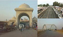
Mohania is the hub of transport routes in Kaimur district. The famous temple Mundeshawari Devi is situated in Kaimur district. The city is on the bank of Durgavati River in south.
Geography
Mohania has an average elevation of 76 metres (249 feet). Mohania is divided into wards. Here is the ancient famous Satti Devi mandir near railway station, White Hanuman mandir. Hanuman mandir is the biggest temple at station road. Here is a beautiful stadium near M.P. College. In the south, there is a river called Durgauti. Mohania is the hub of transport routes in Kaimur district. The famous temple Mundeshawari Devi is situated in Kaimur district. The route for this temple goes through Mohania. Public Transport or hired vehicles are available for the temple Mundeshwari Devi from Railway Station (Bhabua Road) or Bus stand on NH-2.
There is a waterfall Telhar, approx 50 km in south.
Climate
Mohania experiences a humid subtropical climate with large variations between summer and winter temperatures. The temperature ranges between 22 and 46 °C (72 and 115 °F) in the summers. Winters in Mohania see very large diurnal variations, with warm days and downright cold nights. The dry summer starts in April and lasts until June, followed by the monsoon season from July to October. Vk Cold waves from the Himalayan region cause temperatures to dip across the city in the winter from December to February and temperatures below 5 °C (41 °F) are not uncommon. Fog is common in the winters, while hot dry winds, called loo, blow in the summers. The average annual rainfall is 1,110 mm (44 in).
Transport
Mohania is well connected by air, rail and road with the major Indian cities like New Delhi, Mumbai, Kolkata, Chennai, Pune, Ahmedabad, Indore, Bhopal, Bhubaneswar, Gwalior, Jabalpur, Ujjain, Jaipur, Patna, Jamshedpur, Hyderabad etc. The town is 776 km from Delhi, 1240 km from Secunderabad. One of the major factors in Mohania's sustained existence as an inhabited city is its role as an established transportation hub between different cities. It is a subdivisional town in Kaimur district. The district headquarters, Bhabua, is 14 km southward from the railway station.
Road
The town is 180 km from Patna and 60 km from Varanasi by road There are also a few State Highways in the city SH-14.
Mohania is connected to Buxar via Ramgarh from the south and with Bhabua (district capital, Audhaura, Bhagwanpur) from the south.
Railway
The name of the railway station of Mohania is Bhabua Road railway station, situated on Howrah–Gaya–Mughalsarai–New Delhi Grand Cord line. The station code is "BBU".
Airport
Lal Bahadur Shastri International Airport, Varanasi, commonly known as Babatpur Airport, is the nearest airport, 71 km from Mohania. Indian carriers, including Air India, Jet Airways, Kingfisher Airlines, Spicejet, and international carriers like Air India, Thai Airways International, Korean Air and Naaz Airlines, operate from here.