
 | ||
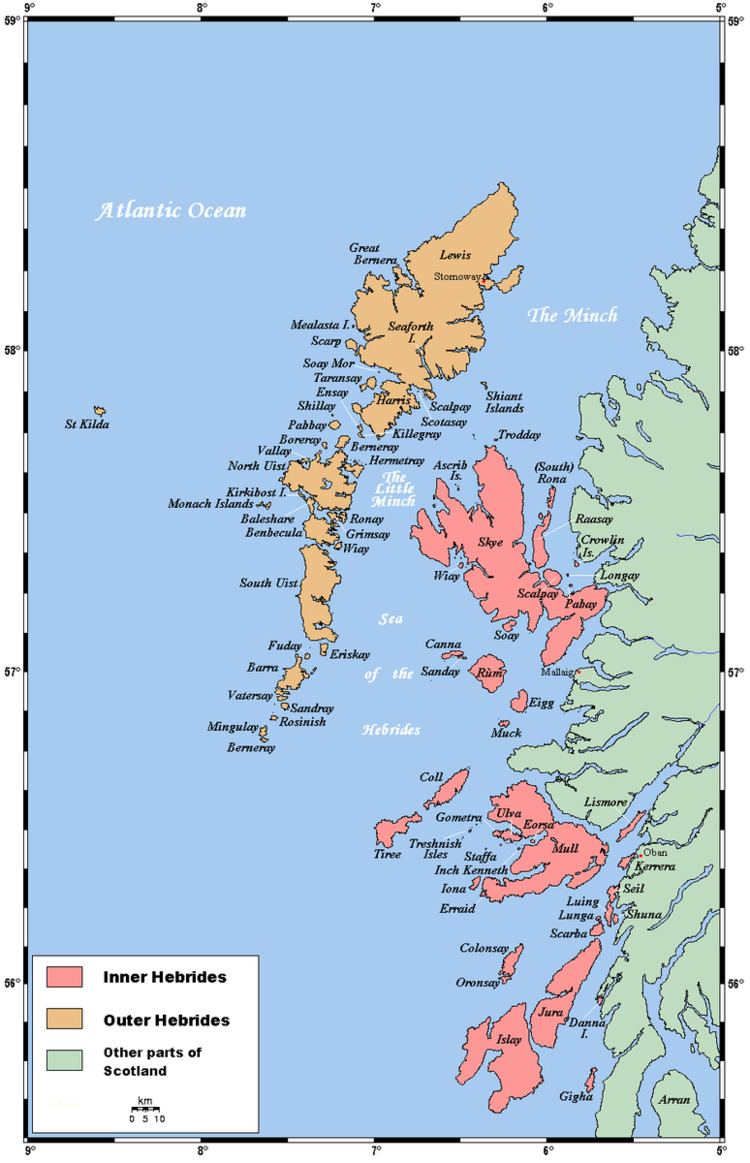
The Outer Hebrides is a chain of more than 100 islands and small skerries located about 70 kilometres (43 mi) west of mainland Scotland. There are 15 inhabited islands in this archipelago, which is also known as the Western Isles and archaically as the Long Isle (Scottish Gaelic: An t-Eilean Fada).
Contents
- Map of Outer Hebrides Isle of Harris UK
- Inhabited islands
- Uninhabited islands
- Smaller islets and skerries
- Barra and the Barra Isles
- Sound of Barra
- South Uist
- Benbecula
- North Uist
- Monach Isles
- Sound of Harris
- West Harris
- East Harris
- Shiant Isles
- South west coast
- Loch Rg
- North west coast
- East Coast
- Small archipelagos
- References
Map of Outer Hebrides, Isle of Harris, UK
Lewis and Harris is the largest island in Scotland and the third largest in the British Isles, after Great Britain and Ireland. It incorporates Lewis in the north and Harris in the south, both of which are frequently referred to as individual islands, although they are joined by a land border. The largest settlement in Lewis and in the Outer Hebrides is Stornoway.
To the south across the Sound of Harris lie the Uists and Benbecula, which were joined by a series of causeways constructed between 1940 and 1960 to improve transport links. Further south are Barra and the smaller Barra Isles, whose southernmost extremity is Barra Head. There are other outliers with cultural links to the Outer Hebrides that are not part of the archipelago itself. These include the St Kilda group, which are quite distinct geologically and no longer inhabited, Sula Sgeir and North Rona to the north and isolated Rockall, which is 367 kilometres (228 mi) to the west of North Uist.
The islands of Scotland's west coast are known collectively as the Hebrides and the Outer Hebrides are separated from the Inner Hebrides by The Minch to the north and the Sea of the Hebrides to the south. The Outer Hebrides are administered by Comhairle nan Eilean Siar and had a population of 26,502 in 2001. The Outer Hebrides have historically been a strong Scottish Gaelic (Gàidhlig) speaking area. Despite recent declines, in the 2001 census more than 50% of the resident population in each island was able to speak Gaelic, for an overall total of 15,842 speakers throughout the archipelago. The modern economy centres on tourism, crofting, fishing, and weaving, the latter of which includes the manufacture of Harris tweed. The archipelago is exposed to wind and tide, and there are numerous lighthouses as an aid to navigation.
The definition of an island used in this list is that it is "land that is surrounded by seawater on a daily basis, but not necessarily at all stages of the tide, excluding human devices such as bridges and causeways".
Inhabited islands
The inhabited islands of the Outer Hebrides had a total population of 26,502 in 2001 and 27,684 at the time of the 2011 census.
The highest peaks of the islands have names deriving from both Gaelic and Old Norse indicating the historical importance of these two cultures. The archeological record for the period of Viking domination during the Early Historic period is however very limited, the Lewis chessmen being an exception.
In addition to the North Ford (Oitir Mhòr) and South Ford causeways that connect North and South Uist, Benbecula and the northern of the two Grimsays in the southern part of the island chain, several other islands are now connected by causeways and bridges. Great Bernera and Scalpay have bridge connections to Lewis and Harris respectively, Baleshare and Berneray are linked to North Uist, Eriskay to South Uist, Flodaigh, Fraoch-eilean and the southern Grimsay to Benbecula, and Vatersay is connected to Barra by a causeway. This means that all of the inhabited islands are now connected to at least one other island by a land transport route.
Ensay, Kisimul Castle and Eilean na Cille are "included in the NRS statistical geography for inhabited islands but had no usual residents at the time of either the 2001 or 2011 censuses".
Uninhabited islands
This is a list of islands with an area greater than 25 hectares (approximately 37 acres). Records for the last date of settlement for the smaller uninhabited islands are incomplete, but most of the islands listed here would have been inhabited at some point during the Neolithic, Iron Age, Early Historic or Norse periods.
In common with the other main island chains of Scotland many of the more remote islands were abandoned during the 19th and 20th centuries, in some cases after continuous habitation since the prehistoric period. This process involved a transition from these places being perceived as relatively self-sufficient agricultural economies to a view becoming held by both island residents and outsiders alike that the more remote islands lacked the essential services of a modern industrial economy.
Some of the islands continue to contribute to modern culture. The "Mingulay Boat Song", although evocative of island life, was written after the abandonment of the island in 1938 and Taransay hosted the BBC television series ‘’Castaway 2000’’. Others have played a part in Scottish history. On 4 May 1746, Bonnie Prince Charlie hid on Eilean Liubhaird with some of his men for four days whilst Royal Navy vessels patrolled the Minch. They camped under a sail stretched over a "low pitiful hut" while it rained torrentially.
The difficulties of definition are considerable in some cases. For example, Haswell-Smith (2004) treats Eileanan Iasgaich as a single island of 50 ha, although during high tides it becomes several tidal islets—none of which is ever connected to the "mainland" of South Uist. Despite its name Eilean an Taighe (English: "house island") in the Shiant Isles does not qualify for inclusion as it is connected to Garbh Eilean by a natural isthmus.
The Eileanan Chearabhaigh are a complex group of islets off the east coast of Benbecula, the area of which changes as the tides rise and fall. The total area is circa 49 hectares and largest part that might be considered to be a genuine island is circa 32 hectares.
Smaller islets and skerries
Smaller islands, tidal islets only separated at higher stages of the tide, and skerries that are only exposed at lower stages of the tide pepper the North Atlantic surrounding the main islands. This is a continuing list of these smaller Outer Hebridean islands.
Many of them are obscure and few have ever been inhabited. Nonetheless, some have a significant degree of notability. The islet on which Kisimul Castle stands is the ancient seat of Clan MacNeil and Shillay in the Monach Isles had a manned lighthouse until 1942. The tiny Beasts of Holm of the east coast of Lewis were the site of the sinking of the Iolaire during the first few hours of 1919, one of the worst maritime disasters in United Kingdom waters during the 20th century. Calvay in the Sound of Barra provided the inspiration for Compton MacKenzie's 1947 novel Whiskey Galore after the SS Politician ran aground there with a cargo of whisky. Unusually for an island without permanent inhabitation, Eilean na Cille (NF847459) is connected to Grimsay (south) by a causeway.
Various Gaelic names are used repeatedly. The suffix ay or aigh or aidh is generally from the Norse øy meaning "island". Eilean (plural: eileanan) also means "island". Beag and mòr (also bheag and mhòr) mean "little" and "big" and are often found together. Sgeir is "skerry" and often refers to a rock or rocks that lie submerged at high tide. Dubh is "black", dearg is "red" and glas means "grey" or "green". Orasaigh is from the Norse Örfirirsey meaning "tidal" or "ebb island".
Smaller islands grouped geographically:
Barra and the Barra Isles
Sound of Barra
South Uist
Benbecula
North Uist
Monach Isles
Sound of Harris
West Harris
East Harris
Shiant Isles
South west coast
Ceann Loch Resort to Aird Dhrolaige: Liongam, Staca Liath
Loch Ròg
North west coast
East Coast
Small archipelagos
There are various small archipelagos within the Outer Hebrides. These include:
The St Kilda group is 64 kilometres (40 mi) west-northwest of North Uist.