
Gaelic name Uibhist a Deas OS grid reference NF786343 Highest elevation 620 m | Meaning of name Pre-Gaelic and unknown Area rank 9 Area 320.3 km² Population 1,818 (2001) Lieutenancy area Outer Hebrides | |
 | ||
Pronunciation [ˈɯ.ɪʃtʲ ə tʲes̪] ( listen) Points of interest Kildonan Museum, Cladh Hallan, Beinn Mhòr, Ormacleit Castle, Beinn Ruigh Choinnich | ||
South Uist (Scottish Gaelic: Uibhist a Deas) is the second-largest island of the Outer Hebrides in Scotland. At the 2011 census it had a usually resident population of 1,754, a fall of 64 since 2001. There is a nature reserve and a number of sites of archaeological interest, including the only location in Great Britain where prehistoric mummies have been found. The population is about 90% Roman Catholic. The island, in common with the rest of the Hebrides, is one of the last remaining strongholds of the Gaelic language in Scotland. In 2006 South Uist, and neighbouring Benbecula and Eriskay, were involved in Scotland's biggest community land buyout to date. In the north west there is a missile testing range. Its inhabitants are known in Gaelic as Deasaich (Southerners).
Contents
- Map of South Uist United Kingdom
- Benbecula and south uist in september
- Geography and geology
- Etymology
- History
- Economy
- Missile testing
- Nature reserve
- Archaeology
- Gaelic
- Notable residents
- References
Map of South Uist, United Kingdom
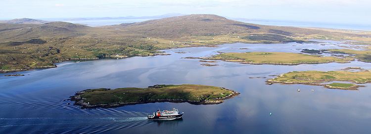
Benbecula and south uist in september
Geography and geology
The west is machair (fertile low-lying coastal plain) with a continuous sandy beach, whilst the east coast is mountainous with the peaks of Beinn Mhòr 620 metres (2,034 ft) and Hecla 606 metres (1,988 ft). The main village on the island is Lochboisdale (Loch Baghasdail), from which ferries sail to Oban on the mainland and to Castlebay (Bàgh a' Chaisteil) on Barra. The island is linked to Eriskay and Benbecula by causeways. Smaller settlements include Daliburgh (Dalabrog), Howmore (Tobha Mòr) and Ludag.
South Uist has a bedrock of Lewisian Gneiss, high grade regional metamorphism dating back to 2900 million years ago in the Archaean. Some show granulite facies metamorphism, but most are the slightly lower temperature amphibolite facies. These formed part of the Earth's deep ancient crust, left here when the North Atlantic was formed. These are the oldest rocks in the British Isles today and they have been brought to the surface by tectonic movements. They now bear the scars of the last glaciation which has exposed them.
"South Uist Machair" on the west coast is one of 40 National Scenic Areas in Scotland.
Etymology
Mac an Tàilleir (2003) suggests that the derivation of Uist may be "corn island". However, whilst noting that the vist ending would have been familiar to speakers of Old Norse as meaning "dwelling", Gammeltoft (2007) says that the word is "of non-Gaelic origin" and that it reveals itself as one of a number of "foreign place-names having undergone adaptation in Old Norse".
History
South Uist was clearly home to a thriving Neolithic community. The island is covered in archaeological sites including chambered tombs, Beaker sites, a Bronze Age hoard, roundhouses, brochs, cairns, ogham inscriptions, Viking settlements, medieval [longhouse]]s and post-medieval industry. Bornais on South Uist was the largest Viking settlement known in Scotland. After the Norse occupation, South Uist was held by the MacDonalds of Clan Ranald, who made a good living from kelp harvesting owing to the demand for kelp around the start of the 19th century. At that time the population of the island was around 7300. After the Napoleonic Wars, however, competition from imported barilla resulted in a collapse in the price for kelp, and the chief of Clan Ranald faced bankruptcy. South Uist was sold to Lt. Colonel John Gordon of Cluny in 1837, and the fortunes of the island's tenants went downhill from that point. He initiated clearances to make way for sheep farming, supplanting the crofters with farmers from the Borders, who brought flocks of Blackface sheep. As a result, there was large scale emigration from the island. Over the years, the population of South Uist has fallen from a total of 5093 in 1841 to its present level of 2285.
Lochboisdale became a major herring port later in the 19th century. The island is one of the last surviving strongholds of the Gaelic language in Scotland, and the crofting industries of peat cutting and seaweed gathering are still an important part of everyday life.
Economy
Tourism is important to the island's economy and attractions include the Kildonan Museum, housing the 16th century Clanranald Stone, and the ruins of the house where Flora MacDonald was born.
South Uist is home to the Askernish Golf Course. The oldest course in the Outer Hebrides, Askernish was designed by Old Tom Morris, who also worked on the Old Course at St Andrews. Morris was commissioned by Lady Gordon Cathcart in 1891. The Askernish course existed intact until the 1930s, but was partly destroyed to make way for an aircraft runway, then abandoned, and ultimately lost. Its identity remained hidden for many years before its apparent discovery, a claim disputed by some locals. Restoration of the course to Morris' original design was held up by disagreements with local crofters, but after legal challenges were resolved in the courts, the course opened in August 2008.
The popular summer music school, Ceòlas, takes place every year from the first Sunday of July in Daliburgh School on the island. It is then followed by the local children's summer school, Fèis Tir a'Mhurain.
After a protracted campaign South Uist residents took control of the island on 30 November 2006 in Scotland's biggest community land buyout to date. The previous landowners, a sporting syndicate, sold the assets of the 92,000 acres (372.31 km2) estate for £4.5 million to a Community Company known as Stòras Uibhist, which was set up to purchase the land and to manage it. The buyout resulted in most of South Uist, and neighbouring Benbecula, and all of Eriskay coming under community control.
The proposal for community ownership received the overwhelming support of the people of the islands, who "look forward to regenerating the local economy, reversing decline and depopulation, and reducing dependency, while remaining aware of the environmental needs, culture and history of the islands". The company name Stòras Uibhist (Uist Resource) symbolises hope for the future wealth and prosperity of the islands.
Missile testing
In the north west of the island at (57°20′N 07°20′W), a missile testing range was built in 1957-58 to launch the Corporal missile, Britain and America's first guided nuclear weapon. This development went ahead despite significant protests, some locals expressing concern that the Scottish Gaelic language would not survive the influx of English-speaking Army personnel. The British Government claimed that there was an 'overriding national interest' in establishing a training range for their newly purchased Corporal, a weapon that was to be at the front line of Cold War defence. The Corporal missile was tested from 1959 to 1963, before giving way to Sergeant and Lance tactical nuclear missiles. The 'rocket range' as it is known locally has also been used to test high altitude research rockets, Skua and Petrel. Local opposition to the range inspired the 1957 novel Rockets Galore by Compton Mackenzie.
The range is still owned by the MoD operated by QinetiQ as a testing facility for missile systems such as the surface-to-air Rapier missile and Unmanned Air Vehicles In 2009 the MOD announced that it was considering running down its missile testing ranges in the Western Isles, with potentially serious consequences for the local economy.
Nature reserve
Loch Druidibeg in the north of the island is a national nature reserve owned and managed by Scottish Natural Heritage. The reserve covers 1,677 hectares of machair, bog, freshwater lochs, estuary, heather moorland and hill. Over 200 species of flowering plants have been recorded on the reserve, some of which are nationally scarce. South Uist is considered the best place in the UK for the aquatic plant Slender Naiad (Najas flexilis) which is a European Protected Species.
Nationally important populations of breeding waders are also present, including redshank, dunlin, lapwing and ringed plover. The reserve is also home to greylag geese on the loch and in summer corncrakes on the machair. Otters and hen harriers are also seen.
There has been considerable controversy over hedgehogs on South Uist. The animals are not native to the islands, having been introduced in the 1970s to reduce garden pests. It is claimed that they pose a threat to the eggs of ground nesting wading birds on the island. In 2003 the Uist Wader Project - headed by Scottish Natural Heritage - began a cull of hedgehogs in the area. Following a campaign and concerns over animal welfare, this cull was called off in 2007; instead hedgehogs are being captured and moved to mainland Scotland.
Archaeology
The SEARCH project (Sheffield Environmental and Archaeological Research Campaign in the Hebrides) on South Uist has been developing a long-term perspective on changes in settlement and house form from the Bronze Age to the 19th century. Organisation within Iron Age roundhouses appears to have been very different from 19th century blackhouses in which the dwelling was shared with stock.
The archaeological site of Cladh Hallan on South Uist is the only site in Great Britain where prehistoric mummies have been found.
Gaelic
According to the 2011 Census, there are 1,888 Gaelic speakers (60%) on South Uist and Benbecula.