
Gaelic name Eilean Hasgeir OS grid reference NF615818 Automated 1997 | Norse name Skilðar Highest elevation 37.5 m Area 15 ha Council area Outer Hebrides Year first constructed 1997 | |
 | ||
Island groups British Isles, Outer Hebrides | ||
Not to be confused with Hyskeir or Heskeir
Contents
Map of Haskeir, United Kingdom
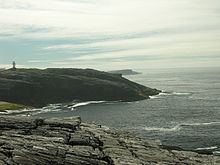
Haskeir (Scottish Gaelic: Eilean Hasgeir), also known as Great Haskeir (Scottish Gaelic: Hasgeir Mhòr) is a remote, exposed and uninhabited island in the Outer Hebrides of Scotland. It lies 13 kilometres (8.1 mi) west north west of North Uist. 1-kilometre (0.62 mi) to the south west lie the skerries of Haskeir Eagach made up of a colonnade of five rock stacks. 40 kilometres (25 mi) to the north west is the St Kilda archipelago.
Geography, geology and botany
There is no anchorage or shelter and access via the steep rocky cliffs may be difficult, even in calm conditions. There are several natural rock arches and a high cliff on the northern end of the island called Castle Cliff. Various small skerries lie immediately to the north and south. There is very little vegetation save for a few sea-pinks, campion, plantain and orache that can survive the salt spray.
Much of the bedrock is Lewisian gneiss
History
Skilðar or Skilðir (meaning shields) may have been the Old Norse name for Haskeir. Skildar certainly appears on a map by Nicholas de Nicolay from 1583. There are various theories that somehow the transposition of this name to nearby St Kilda may have created the name for this latter archipelago, whose origins are otherwise obscure.
There is an active lighthouse on the island constructed in 1997 operated by Northern Lighthouse Board and the remains of a bothy, possibly built by fishermen from the Monach Islands.