
Length 12.6 km | ||
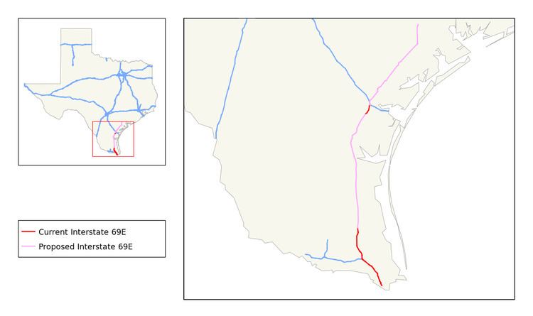 | ||
North end: I-69E north / US 77 north / SH 44 in Robstown | ||
Interstate 69e brownsville texas
Interstate 69E (I-69E) is a relatively short south–north freeway running through South Texas. Once complete the freeway will begin in Brownsville and head northward before terminating near Victoria as both I-69W and I-69E intersect into Interstate 69 towards Houston. For its entire length, I-69E shares its alignment with US 77.
Contents
Map of I-69E, Texas, USA
History
A stated goal of Texas Department of Transportation's (TxDOT) I-69 initiative is that "existing suitable freeway sections of the proposed system be designated as I-69 as soon as possible." A bill was introduced and passed by the House of Representatives that allows interstate quality sections of US 59, US 77, and US 281 to be signed as I-69 regardless of whether or not they connected to other interstate highways.
Texas Department of Transportation submitted an application to the Federal Highway Administration (FHWA) and the American Association of State Highway and Transportation Officials (AASHTO) to designate 75 miles of US 59 in the Houston area and 8 miles of US 77 near Corpus Christi as I-69, as these sections are already built to interstate standards and connect to other interstate highways. In August 2011, TxDOT received approval from FHWA for a six-mile segment of US 77 between I-37 and SH 44 near Corpus Christi, and was approved by the AASHTO in October 2011. Officials held a ceremony on December 5, 2011 to unveil I-69 signs on the Robstown-Corpus Christi section.
The Federal Highway Administration approved the designation for the East Rio Grande Valley Segment on May 24, 2013, and the Texas Transportation Commission followed suit on May 30, 2013. This action finalized the designations of not only I-69E, but also of the sections of I-69C from Pharr north to the end of the US 281 freeway facility near Edinburg, and also Interstate 2 (I-2), which is a 46.8-mile (75.3 km) freeway that runs from Palmview to Harlingen and connects with I-69C and I-69E. These approvals added over 100 miles (160 km) to the Interstate Highway System in the Rio Grande Valley. The signage was installed in summer 2013.
As of June 2013, the cluster consisting of the recently designated portions of I-69E, I-69C, and I-2 in the Rio Grande Valley is not connected to the national Interstate network. This situation is slated to be remedied by scheduled projects to complete I-69E along US 77 between Raymondville and Robstown, and to complete the southern end of the previously signed portion of the I-69 corridor connecting with I-37 west of Corpus Christi. Environmental Protection Agency approval for the upgrade of the US 77 alignment to Interstate standards, including bypasses of the towns along the 91-mile (146 km) routing, was obtained through a Finding of No Significant Impact statement issued on July 13, 2012; funding for the various projects to effect the upgrades is slated to become available after 2015.