
 | ||
The history of Saskatoon began with the first permanent settlement of Saskatoon, Saskatchewan, Canada, in 1883 when Toronto Methodists, wanting to escape the liquor trade in that city, decided to set up a "dry" community in the rapidly growing prairie region. As of 1882 this area was a part of the provisional district named Saskatchewan, North-West Territories. Their organization, the Temperance Colonization Society, first examined this area in 1882 and found that it would make an excellent location to found their community based on the ideals of the temperance movement. The settlers, led by John Neilson Lake, arrived on the site of what is now Saskatoon by traveling by railway from Ontario to Moose Jaw, Saskatchewan, and then completing the final leg via horse-drawn cart (the railway had yet to be completed to Saskatoon). The plan for the Temperance Colony soon failed as the group was unable to obtain a large block of land within the community. Nonetheless, John Lake is commonly identified as the founder of Saskatoon; a public school, a park and two streets are named after him (Lake Crescent, which was developed in the 1960s, and Eastlake Avenue, originally Lake Avenue (as testified on the first map of Saskatoon from 1883), but later changed for reasons unknown).
Contents
- Hub city and agricultural boom
- Post War years
- Sask a boom
- Location in relation to neighbouring communities
- References
In 1885, several houses on 11th Street East were used as military hospitals during the North-West Rebellion. One house, the Marr Residence, is currently a heritage site run by the Meewasin Valley Authority. The first school, Victoria School, opened for classes at the corner of 11th Street and Broadway Avenue in 1888. This small school, now called the "Little Stone Schoolhouse", now sits on the campus of the University of Saskatchewan.
Hub city and agricultural boom
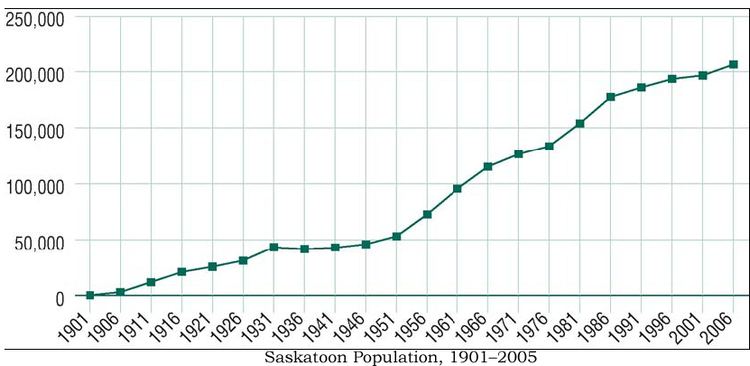
The Qu'Appelle, Long Lake and Saskatchewan Railway reached Saskatoon in 1890 and crossed the South Saskatchewan River where the Senator Sid Buckwold Bridge now stands, causing a boom in development on the west side of the river. In 1901, Saskatoon's population hit 113. A third settlement, Riversdale, also began just southwest of Saskatoon.
1903 saw an economic boom for Saskatoon with the encampment of Barr colonists on their way to the Brittania colony. A town charter for the west side of the river was obtained in 1903; Nutana became a village in the same year.
April 1904 saw the collapse of the rail bridge due to spring melt and ice on the South Saskatchewan River. The Grand Trunk Pacific Railway system survey proposed Hanley as its northern terminal between Regina and Prince Albert. Saskatoon's Board of Trade sent delegates from Saskatoon to Ottawa to discuss the river crossing and proposed city bridges. Their mission resulted in the selection of Saskatoon as the divisional centre for both the Canadian Pacific Railway and the Grand Trunk Pacific Railway; both of these built bridges near the town by 1907. The QLL&SR bridge was rebuilt in 1905, and again after a train fell through it in March 1914; it was demolished in 1965 to make way for the Senator Sid Buckwold Bridge and the Idylwyld Freeway.
In 1906 Saskatoon became a city with a population of 4,500, which included the communities of Saskatoon, Riversdale, and Nutana.
Following the formation of the Province of Saskatchewan September 1, 1905, premier Hon. Walter Scott focused on the creation of a provincial university and agricultural college. Moose Jaw, Prince Albert, Saskatoon, Regina, Qu'Appelle, Indian Head and Battleford were all under consideration for this location. President Walter Murray and the Board of University Governors voted in favour of Saskatoon on April 7, 1907.
1907 saw the completion of the Traffic Bridge, as well as the CPR Bridge and Grand Trunk Pacific GTP Railway Bridge. The geographical barrier: South Saskatchewan River between Nutana and West Saskatoon was overcome with the building of the Traffic Bridge, which opened in 1907. The physical barrier of the CNR rail yards isolated Riversdale and Saskatoon. Road underpasses below the rail line were built at 19th and 23rd Streets, and a wooden pedestrian overpass at 20th Street.
From the end of the Louis Riel Rebellion to 1913, Saskatoon was celebrating boom years. The main contributing factors of the exponential growth were:
Post-War years
After World War I, the Dirty Thirties and Depression years saw migration away from bankrupt farms and towards a hope of employment in the cities. The socio-economic changes brought about by World War II and the industrial revolution saw a shift from rural life to urban living. Saskatoon was not only a centre for the British Commonwealth Air Training Plan during the 1940s, but also became a major regional distribution and service centre. Saskatoon experienced a severe shortage of residential dwellings between 1945 and 1960.
During the 1960s, the CNR rail yards were relocated to Chappell Drive, making room for the Idylwyld Freeway and Midtown Plaza in the first Saskatoon Downtown revitalisation project.
In 1906, the boundaries of Saskatoon were Clarence Avenue to the east, Taylor Street to the south, Avenue P to the west, and 33rd Street East to the north. This area is roughly the same as the core neighborhood suburban development area. These boundaries remained basically the same for approximately 40 years until Saskatoon reached financial stability during World War II. The following suburban development areas saw neighborhoods developed between 1940 and 1980: Nutana SDA on the east side; on the west side Confederation SDA and Lawson SDA. In 1955, Montgomery Place and in 1956 the neighboring town of Sutherland were annexed by the quickly growing City of Saskatoon This growth continued until the mid-1980s.
Technological, educational and cultural amenities have also expanded to meet the increased demand in this growing city.
Sask-a-boom
Saskatoon's first growth spurt gained Saskatoon the nickname Hub City, whereas the latest growth phenomenon has been termed Sask-a-boom. The 10-year capital deficiency discussion paper for 2007–2016 has recently been updated for 2007. The new priority for the civic government are infrastructure needs and proposed new capital projects for the population increases and for the physical geographical growth. The phenomenal retail sector increase, new neighborhoods and communities place a demand upon the city to provide additional firehalls, transit buses, police headquarters, libraries, water plants, electrical power plants, bridges, interchanges and roadways. Brookside, Rosewood, Stonebridge, The Willows, Willowgrove, University Heights Suburban Centre, Hampton Village, Hudson Bay Industrial, Marquis Industrial, Blairmore Suburban Centre, and another 10 unnamed proposed neighborhoods are being developed or are currently under construction.
A further annexation of extensive areas to the north, northeast and east of the city took place in July 2010.
On August 24, 2010, the Traffic Bridge, which symbolized the uniting of Saskatoon, Nutana and Riversdale into one city, was closed indefinitely due to structural integrity concerns were raised. In 2011 city council decided to replace the iconic bridge, but to date this has yet to occur.
Location in relation to neighbouring communities
Saskatoon became a city with the amalgamation with the above three communities, however the current size of Saskatoon has meant that the geographical presence of Saskatoon has encompassed several other early communities.
Currently Saskatoon is considered to be located encompassing townships 36 and 37, range 5 and township 36, range 6, west of the Third Meridian. (See also Dominion Land Survey – Each township is a 6-mile (10 km) square.)