
- elevation 3,747 m (12,293 ft) Area 1.781 million km² | - elevation 0 m (0 ft) | |
Provinces | ||
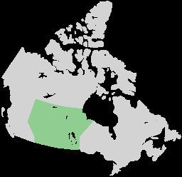
The Canadian Prairies is a region in western Canada, which may correspond to several different definitions, natural or political. Notably, the Prairie provinces or simply the Prairies comprise the provinces of Alberta, Saskatchewan, and Manitoba, as they are partially covered by prairie (grasslands). In a more restricted sense, the term may also refer only to the areas of those provinces covered by prairie; their portions of the physiographic region known as the Interior Plains. Prairie also covers portions of northeastern British Columbia, though that province is typically not included in the region in a political sense.
Contents
- Cruising the canadian prairies in my gyrocopter
- Definitions
- Main climates
- Physical geography
- Prairies
- Demographics
- Growth
- Economy
- Culture and politics
- References
Cruising the canadian prairies in my gyrocopter
Definitions
The prairies in Canada refers to temperate grasslands and shrublands biome, within the prairie ecoregion of Canada and consists of Northern mixed grasslands in Alberta, Saskatchewan, and southern Manitoba. Northern short grasslands in southeastern Alberta and southwestern Saskatchewan. Northern tall grasslands in southern Manitoba, and Aspen parkland, which covers central Alberta, central Saskatchewan, and southern Manitoba. The Prairie starts from north of Edmonton, it covers the three provinces east to the Manitoba-Minnesota border.

However "the prairies" may also refer to all of the Interior Plains region within Canada, in contrast with the Rocky Mountains and the Canadian Shield, and is a continuation of the Great Plains region of the United States.
Main climates
According to the Köppen climate classification the Canadian prairies generally experience dry semi-arid climates (Köppen Bsk) in the brown soil regions, and somewhat dry Humid Continental climates (Köppen Dfb) in the outer dark brown and black soil areas. The Canadian prairies typically experience about 12 to 15 in (300 to 380 mm) of annual precipitation in the semi-arid areas while they experience 16 to 20 in (410 to 510 mm) in the continental regions. Manitoba is generally the coldest and most humid of the three prairie provinces. The area is also prone to thunderstorms in the spring and summer. Some of these storms, especially further south, are strong enough for tornadoes.
Physical geography
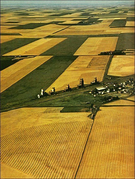
Although the Prairie Provinces region is named for the prairies located within Alberta, Saskatchewan and Manitoba, the physical geography of the three provinces is quite diverse, consisting of portions of the Canadian Shield, the Western Cordillera and the Canadian Interior Plains. The plains comprise both prairies and forests while, with the exception of Arctic tundra along the Hudson Bay, the shield is predominantly forested.
Prairies
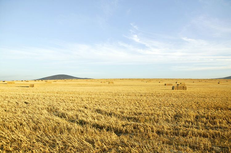
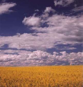
Three main grassland types occur in the Canadian prairies: tallgrass prairie, mixed grass prairie, and fescue prairie (or using the WWF terminology, northern tall grasslands, northern mixed grasslands, and northern short grasslands). Each has a unique geographic distribution and characteristic mix of plant species. All but a fraction of one percent of the tallgrass prairie has been converted to cropland. What remains occurs on the 6,000 km2 (2,300 sq mi) plain centred in the Red River Valley in Manitoba. Mixed prairie is more common and is part of the dry interior plains that extend from Canada south to the U.S. state of Texas. More than half of the remaining native grassland in the Canadian prairies is mixed. Though widespread in southern Saskatchewan and southeastern Alberta, because of extensive cattle grazing, it is estimated that only 24% of the original mixed prairie grassland remains. Fescue prairie occurs in the moister regions, occupying the northern extent of the prairies in central and southwestern Alberta and west-central Saskatchewan.
The southwestern Canadian prairies, supporting brown and black soil types, are semi-arid and highly prone to frequent and severe droughts. The zones around the cities of Regina and immediately east of Calgary are also very dry. Most heavy precipitation quickly dissipates by the time it passes Cheadle on its way heading east. In an average year, southern Saskatchewan receives between 30–51 cm (12–20 in) of precipitation, with the majority falling between April and June. Frost from October to April (and sometimes even early May) limits the growing season for certain crops.
The eastern section of the Canadian prairies in Manitoba is well watered with several large lakes such as Lake Winnipeg and several large rivers. The area also gets reasonable amounts of precipitation. The middle sections of Alberta and Saskatchewan are also wetter than the south and have better farmland, despite having a shorter frost-free season. The areas around Edmonton and Saskatoon are especially notable as good farmland. Both lie in the northern area of the Palliser's Triangle, and are within aspen parkland a transitional prairie ecozone.
Further north, the area becomes too cold for most agriculture besides wild rice operations and sheep raising, and it is dominated by boreal forest. The Peace Region in northwestern Alberta is an exception, however. It lies north of the 55th Parallel and is warm and dry enough to support extensive farming. Aspen parkland covers the area; The long daylight hours in this region during the summer are an asset despite having an even shorter growing season than central Alberta. In fact, agriculture plays a major economic role in the Peace Region.
Demographics
In the Canada 2011 Census, the Canadian prairie provinces had a population of 5,886,906, consisting of 3,645,257 in Alberta, 1,208,268 in Manitoba, and 1,033,381 in Saskatchewan, up 8.9% from 5,406,908 in 2006. The three provinces have a combined area of 1,780,650.6 km2 (687,513.0 sq mi), consisting of 640,081.87 km2 (247,136.99 sq mi) in Alberta, 552,329.52 km2 (213,255.62 sq mi) in Manitoba, and 588,239.21 km2 (227,120.43 sq mi) in Saskatchewan.
Growth
Some of the prairie region of Canada has seen rapid growth from a boom in oil production since the mid-20th century.
Economy
Primary industries include agriculture (wheat, barley, canola, brassica, oats), and cattle and sheep ranching. Also, natural resources such as oil sands (Fort McMurray, Alberta) and other forms of oil production can be found on the plains. Secondary industries consist of the refinement of oils and agriculture processing.
Culture and politics
The Prairies are distinguished from the rest of Canada by cultural and political traits. The oldest influence on Prairie culture are the First Nations, who have lived in the area for millennia. The first Europeans to see the Prairies were fur traders and explorers from eastern Canada (mainly present-day Quebec) and Great Britain via Hudson Bay. They gave rise to the Métis, working class "children of the fur trade." Not until the Canadian Pacific Railway was built did widespread agricultural settlement occur. During their settlement, the prairies were settled in distinct ethnic block settlements giving certain areas distinctively Ukrainian, German, French, or Scandinavian Canadian cultures.
Some areas also developed cultures around their main economic activity. For example, southern Alberta is renowned for its cowboy culture, which developed when real open range ranching was practiced in the 1880s. Canada's first rodeo, the Raymond Stampede, was established in 1902. These influences are also evident in the music of Canada's Prairie Provinces. This can be attributed partially to the massive influx of American settlers who began to migrate to Alberta (and to a lesser extent, Saskatchewan) in the late 1880s because of the lack of available land in the United States.
The Prairie Provinces have given rise to the "prairie protest" movements, such as the Winnipeg General Strike of 1919, the first general strike in Canadian history. These political movements (both of the left and right) tend to feed off of well established feelings of Western alienation, and each one represents a distinct challenge to the perceived Central Canadian elite.
The Prairies continue to have a wide range of political representation. While the Conservative Party of Canada has widespread support throughout the region, the New Democratic Party holds seats at the provincial level in all three provinces, forming the government in one, as well as holding seats at the federal level in all three provinces. The Liberal Party of Canada presently holds federal seats in urban areas of Alberta, Saskatchewan and Manitoba, while the Alberta Liberal Party holds a provincial seat in Alberta and the Manitoba Liberal Party holds a seat in Manitoba.