
Suburban Development Area Core Neighbourhoods Settled 1890 (as Richville) Area 87 ha Local time Sunday 6:56 PM | Neighbourhood Riversdale Incorporated (village) 1905 (as Riversdale) Population 2,135 (2011) | |
 | ||
Weather 4°C, Wind W at 23 km/h, 39% Humidity Restaurants Leyda's Cafe, The Hollows Restaurant, Thrive Juice Co, The Grazing Goat, Little Bird ‑ Patisserie & Cafe | ||
Riversdale is one of the oldest neighbourhoods in Saskatoon, Saskatchewan, Canada, located near the downtown area. It includes the business district of 20th Street. It consists mostly of low-density, single detached dwellings. As of 2011, the area was home to 2,135 residents.
Contents
- Map of Riversdale Saskatoon SK Canada
- History
- Historic buildings
- Government and politics
- Education
- Public safety
- Other
- Arts and culture
- Parks and recreation
- Commercial
- Transportation
- Location
- References
Map of Riversdale, Saskatoon, SK, Canada
Riversdale has experienced an economic and development boom since 2012 and has even been called Canada's Next Great Neighbourhood. However, the neighbourhood is still considered a lower-income area, with (based on the 2006 Canadian Census) an estimated average family income of $35,849, an estimated average dwelling value of $120,835 and an estimated home ownership rate of 36.0% According to MLS data, the average sale price of a home as of 2013 was $224,807.
Incorporated as a town in 1905, Riversdale was one of the three original settlements that merged to form the city of Saskatoon in 1906.
History
The first record of settlement in the Riversdale area was in the 1890s, when the area was homesteaded. It was dubbed "Richville" after one of the original settlers. In April 1903, over 1500 Barr Colonists arrived and made camp just west of the railway tracks beside Saskatoon. While most of the colonists moved on to the Lloydminster area, some remained behind as permanent residents of a new settlement. The village of Riversdale was incorporated on January 16, 1905. The village plan (originally called "Riverdale") had narrower streets, smaller lots, and no public reserve land. Faced with a heavy influx of settlers, Riversdale joined with the towns of Saskatoon and Nutana to become the City of Saskatoon on July 1, 1906.
Immigration from central and eastern Europe brought new and ethnically diverse peoples to Riversdale around 1908. Many British, German, Ukrainian and Chinese families took up residence. Separated from the downtown by the Canadian Northern Railway yards, vehicular access to Riversdale was limited to underpasses at 19th and 23rd Streets. In 1910, a pedestrian walkway was built over the train tracks at 20th Street so the public could safely cross the tracks on foot. Saskatoon's Chinatown moved into the Riversdale district in the early 1930s. Originally, Chinese immigrants set up businesses along 19th Street east of the CN tracks, in what is now the south downtown. However, they moved when the city acquired the land to build the Saskatoon Technical Collegiate (later the Gathercole Building, now demolished).
The mid-1960s marked a change in the traffic patterns of the area, as the CN tracks were relocated out of downtown. 20th and 22nd Streets were connected to the downtown, and Idylwyld Drive became Riversdale's eastern boundary. The 23rd Street underpass was levelled quickly, while the 19th Street overpass remained until 2006. The mid-60s also saw First Nations people moving off of reserves and into Riversdale – the most recent statistics show that 43% of the population identifies as being of First Nations origin. Vietnamese and Hong Kong Chinese immigrants also began arriving at this time.
Riversdale's image struggled since the 1960s, with a sizeable portion of the population living below the poverty line. The social ills that accompany poverty – substance abuse, violent crime and dilapidated housing – often cast the area in a negative light. However, by 2009 there was evidence of gentrification occurring in the area, including the River Landing development and the demolition of the historic but run-down Barry Hotel being cited as examples of the neighbourhood's changing character. By 2014, new businesses occupied nearly all of the available rental space.
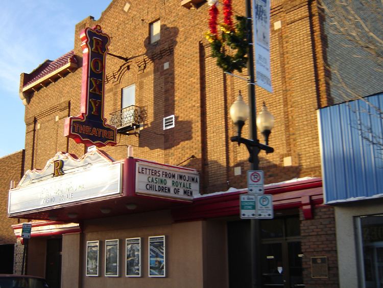
Historic buildings
Government and politics
Riversdale exists within the federal electoral district of Saskatoon-Rosetown-Biggar. It is currently represented by Kelly Block of the Conservative Party of Canada, first elected in 2008.
Provincially, the area overlaps two constituencies. The west part is within the constituency of Saskatoon Riversdale. It is currently represented by Danielle Chartier of the Saskatchewan New Democratic Party (NDP), first elected in a 2009 by-election. The east part lies within the constituency of Saskatoon Centre. It is currently represented by David Forbes of the NDP, first elected in a 2001 by-election and re-elected in 2003 and 2007.
In Saskatoon's non-partisan municipal politics, Riversdale lies within ward 2. It is currently represented by Councillor Pat Lorje. She was first elected in 1979, and was re-elected in 1982, 1985, and 1988. After a period of time as a NDP member of the Legislative Assembly of Saskatchewan, Lorje was again elected as Ward 2 councillor in 2006 and re-elected in 2009.
Education
Public safety
Other
Arts and culture
Parks and recreation
The Riversdale Community Association coordinates educational, recreational, and social programs for residents, maintains the outdoor rink at Princess Alexandra Community School, stages fundraising events, and works to address issues of local concern.
Commercial
Riversdale's main commercial corridor is 20th Street, which was the main street in its early days as a village. Today, 20th Street is home to mainly independently-owned local businesses. Other businesses are located on 22nd Street, the major arterial road that makes up the northern boundary of Riversdale. Commercial and light industrial businesses occupy some of the blocks between 19th and 22nd Streets, concentrated on the eastern side closer to Idylwyld Drive. The Saskatoon Farmers' Market, founded in 1975, moved into its present location at 19th Street and Avenue B in 2007.
Transportation
Riversdale is served by Saskatoon Transit bus routes #2, #9 #10, #60 and #65. Route #5 also runs along 23rd Street, a block north of the neighbourhood boundary.
Location
Riversdale is located within the Core Neighbourhoods Suburban Development Area. It is bounded by 22nd Street to the north and Idylwyld Drive to the east. The southern boundary starts at the Senator Sid Buckwold Bridge, follows the South Saskatchewan River west until where it intersects an imaginary extension of 18th Street; it follows 18th Street west with a few turns until roughly Avenue K. The western boundary comprises the CPR tracks in the northwest until Avenue K, then a few turns until roughly 18th Street. Roads are laid out in a grid fashion; streets run east-west, avenues run north-south.