
- elevation 700 m (2,297 ft) Basin area 146,100 km² Discharge 280 m³/s Sources Bow River, Oldman River | - elevation 380 m (1,247 ft) Length 1,392 km Mouth Saskatchewan River | |
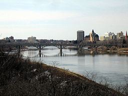 | ||
- location Municipal District of Taber, Alberta - location Saskatchewan River Forks, Saskatchewan - average 249 m/s (8,793 cu ft/s) Bridges Traffic Bridge, Broadway Bridge, University Bridge Similar Traffic Bridge, Broadway Bridge, Delta Bessborough, University Bridge, Wanuskewin Heritage Park | ||
Mud sand the south saskatchewan river part 1 can am commander 1000xt
The South Saskatchewan River is a major river in Canada that flows through the provinces of Alberta and Saskatchewan.
Contents
- Mud sand the south saskatchewan river part 1 can am commander 1000xt
- Map of South Saskatchewan River Canada
- South saskatchewan river camping and canoe trip alberta canada july 2011
- CourseEdit
- TributariesEdit
- IslandsEdit
- Fish speciesEdit
- References
Map of South Saskatchewan River, Canada
For the first half of the 20th century, the South Saskatchewan would completely freeze over during winter, creating spectacular ice breaks and dangerous conditions in Saskatoon, Medicine Hat and elsewhere. At least one bridge in Saskatoon was destroyed by ice carried by the river. The construction of the Gardiner Dam in the 1960s, however, lessened the power of the river by diverting a substantial portion of the South Saskatchewan's natural flow into the Qu'Appelle River. By the 1980s many permanent sandbars had formed due to the lowering of the level of the river.
From the headwaters of the Bow River, the South Saskatchewan flows for 1,392 kilometres (865 mi). At its mouth at Saskatchewan River Forks, it has an average discharge of 280 cubic metres per second (9,900 cu ft/s) and has a watershed of 146,100 square kilometres (56,400 sq mi), 1,800 of which are in Montana in the United States and 144,300 square kilometres (55,700 sq mi) in Alberta and Saskatchewan.
South saskatchewan river camping and canoe trip alberta canada july 2011
CourseEdit
The river originates at the confluence of the Bow and Oldman Rivers near Grassy Lake, Alberta. The waters of these two rivers, in turn, originate from glaciers in the Rocky Mountains near the British Columbia and Montana border. The Red Deer River is a major tributary of the South Saskatchewan merging 16 kilometres (10 mi) east of the Alberta-Saskatchewan border. The Lake Diefenbaker reservoir was created with the construction of the Gardiner and Qu'Appelle River dams in Saskatchewan. Water from the South Saskatchewan flowing through the dams provides approximately 19 percent of the hydro-electricity generated by SaskPower.
Downstream from the dam the river flows north through Saskatoon and joins the North Saskatchewan River east of Prince Albert at the Saskatchewan River Forks — thus forming the Saskatchewan River. For approximately 60 kilometres (37 mi) near Saskatoon, the Meewasin Valley Authority is responsible for conservation of the river environment. Numerous lakes in the Saskatoon area were formed by oxbows of the South Saskatchewan River, most notably Moon Lake and Pike Lake.
A 2009 report, produced by WWF-Canada which analysed the river flow on 10 major Canadian rivers reported that the South Saskatchewan River was the most at risk. Climate change, agricultural and urban infrastructure water use, and dams producing hydroelectricity, have all combined to reduce the flow of the South Saskatchewan River by 70 percent. Developers and governments have been cautioned to protect and restore the river with sustainable projects and limit water diversion. Dickson Dam regulates water supply downstream on the Red Deer River; the Bassano Dam and 11 other dams divert water on the Bow River and in the Bow River basin; and the Oldman River Dam and Waterton-St. Mary Headworks System manage water flow downstream of the Oldman River. The proposed Meridian dam 30 kilometres (19 mi) west of Leader and 95 kilometres (59 mi) north east of Medicine Hat was cancelled due to project costs outweighing the irrigation benefits.
TributariesEdit
IslandsEdit
Partial list
Fish speciesEdit
Fish species include walleye, sauger, yellow perch, northern pike, lake trout, rainbow trout, goldeye, lake whitefish, cisco, lake sturgeon, burbot, quillback, longnose sucker, white sucker and shorthead redhorse.