
 | ||
England is divided into a number of different regional schemes for various purposes. Since the creation of the Government Office Regions in 1994 and their adoption for statistical purposes in 1999, some historical regional schemes have become obsolete. However, many alternative regional designations also exist and continue to be widely used.
Contents
Informal regions
Informal and overlapping regional designations are often used to describe areas of England. They include:
Counties
In two cases historic counties, long abandoned as units for administrative purposes, have continued to be widely recognised as cultural regions, significant in sport and used by many organisations as regional units.
Britain in Bloom regions
Britain in Bloom divides England into 12 regions. They are broadly the same as the government office regions, except that Cumbria is a region in itself, and South East England is divided into three – Thames and Chilterns, Southern England and a rump South East England.
National Trust
The National Trust has 10 regional offices in England. These are
500–850
After the end of the Roman occupation of Britain, the area now known as England became divided into seven Anglo-Saxon kingdoms: Northumbria, Mercia, East Anglia, Essex, Kent, Sussex and Wessex . A number of other smaller political divisions and sub-kingdoms existed. The kingdoms were eventually united into the Kingdom of England in a process beginning with Egbert of Wessex in 829 and completed by King Edred in 954.
1655–1657
During The Protectorate, Oliver Cromwell experimented with the Rule of the Major-Generals. There were ten regional associations covering England and Wales administered by major-generals. Ireland under Major-General Henry Cromwell, and Scotland under Major-General George Monck were in administrations already agreed upon and were not part of the scheme.
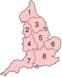
Economic planning regions
Eight economic planning regions were named by the Secretary of State for Economic Affairs, George Brown in December 1964. These were:
Standard statistical regions
Before the adoption of the government office regions for statistics, there were eight 'standard statistical regions':
- North – current North East plus Cumbria
- North West – current North West less Cumbria
- Yorkshire and Humberside – as current Yorkshire and The Humber
- West Midlands – as now
- East Midlands – as now
- East Anglia – Norfolk, Suffolk, and Cambridgeshire
- South West – as now
- South East – as now, plus Greater London, Bedfordshire, Essex, and Hertfordshire
Civil defence regions
The present government office regions closely resemble Civil Defence Regions. During the latter part of the Cold War, the United Kingdom was divided into 11 such regions, most of which were divided themselves into sub-regions. The regions were numbered as shown in the list, numbers for sub-regions were of the form 11.
The regions were based on pre-Second World War regions, but were substantially altered in the 1970s, with the merger of South East and Southern regions, and alterations in the north. They were again altered in 1984, to merge the English regions 1 and 2 to become a single North East region, and Scotland's two southern regions (East and West Zones) becoming a single South Zone.
1980s
From the mid-1980s, the eight English Civil Defence Regions were as follows (using 1974/1975 boundaries):
- North East England
- (North East England) – Cleveland/Durham/Northumberland/Tyne and Wear
- (Yorkshire and the Humber) – Humberside/North Yorkshire/South Yorkshire/West Yorkshire
- East Midlands
- Derbyshire/Lincolnshire/Nottinghamshire
- Leicestershire/Northamptonshire
- East of England
- (East Anglia) – Cambridgeshire/Norfolk/Suffolk
- Bedfordshire/Essex/Hertfordshire
- Greater London – see Civil defence centres in London for sub-regions
- South East England
- East Sussex/Kent/Surrey/West Sussex
- Berkshire/Buckinghamshire/Hampshire/Isle of Wight/Oxfordshire
- South West England
- Avon/Dorset/Gloucestershire/Somerset/Wiltshire
- Cornwall/Devon
- West Midlands
- Staffordshire/Warwickshire/West Midlands
- Hereford and Worcester/Shropshire
- North West England
Redcliffe-Maud provinces
The Redcliffe-Maud Report produced by the Royal Commission on local government reform in 1969 recommended the creation of eight provinces. In approximate terms, these were to be:
- North East – per North East England
- Yorkshire – per Yorkshire and the Humber
- North West – per North West England, excluding southern Cheshire
- West Midlands – per West Midlands, including southern Cheshire
- East Midlands – per East Midlands, less Northamptonshire and southern Lincolnshire
- South West – per South West England
- East Anglia – Cambridgeshire, Norfolk, Suffolk, northern Essex, southern Lincolnshire
- South East – South East England and Greater London with Northamptonshire, Hertfordshire, Bedfordshire, southern Essex