
Capital | ||
Destinations Colleges and Universities Harbin Institute of Technology (Harbin), Harbin Engineering University (Harbin), Northeast Forestry University (Harbin), Heilongjiang University (Harbin), Northeast Agricultural University (Harbin) | ||
Languages spoken | ||
Map of Heilongjiang
Heilongjiang (Chinese: 黑龙江; pinyin: Hēilóngjiāng ) is a province of the People's Republic of China. Located in the northeastern part of the country, Heilongjiang is bordered by Jilin to the south and Inner Mongolia to the west. It also shares a China–Russia border with Russia to the north and east. The capital and the largest city of the province is Harbin. Among Chinese provincial level Administrative divisions, Heilongjiang is the 6th largest by total area and the 15th most populous.
Contents
- Map of Heilongjiang
- Episode 3 of bird s eye china heilongjiang the northernmost province
- Harbin heilongjiang china 2017
- Etymology
- History
- Geography
- Climate
- Transport
- Amur Bridge Project
- Administrative divisions
- Politics
- Economy
- Economic and technological development zones
- Demographics
- Religion
- Culture
- Media
- Tourism
- Colleges and universities
- Sports
- References
The province takes its name from the Heilong River (Chinese name of the Amur), which marks the border between the People's Republic of China and Russia. Heilongjiang contains China's northernmost point (in Mohe County along the Amur) and easternmost point (at the junction of the Amur and Ussuri rivers).
Heilongjiang is China's largest agricultural base, as well as an important industrial area mainly based on oil, timber, coal and machinery manufacturing.
Episode 3 of bird s eye china heilongjiang the northernmost province
Harbin heilongjiang china 2017
Etymology
"Heilongjiang" literally means Black Dragon River, which is the Chinese name for the Amur. The one-character abbreviation is 黑 (pinyin: Hēi). The Manchu name of the region is Sahaliyan ula (literally, "Black River"), from which the name of Sakhalin is derived, and the Mongolian name with the same meaning is Qaramörin.
History
Ancient Chinese records and other sources state that Heilongjiang was inhabited by people such as the Buyeo, the Mohe, Balhae and the Khitan. Mongolic Donghu people lived in Inner Mongolia and the western part of Heilongjiang. Some names are Manchu or Mongolian. The eastern portion of Heilongjiang was ruled by the kingdom of Balhae between the 7th century and 10th century. The Jurchen Jin dynasty (1115–1234) that subsequently ruled much of north China arose within the borders of modern Heilongjiang.
Heilongjiang as an administrative entity was created in 1683, during the Kangxi era of the Manchu Qing Dynasty, from the northwestern part of the Jilin province. This Heilongjiang Province only included the western part of today's Heilongjiang Province, and was under the supervision of the General of Heilongjiang (Sahaliyan Ula i Jiyanggiyūn) (the title is also translated as the Military Governor of Heilongjiang; jiyanggiyūn is the Manchu reading of the Chinese word 將軍 jiāngjūn "military leader, general" and is cognate with Japanese shōgun), whose power extended, according to the Treaty of Nerchinsk, as far north as the Stanovoy Mountains. The eastern part of what's today Heilongjiang remained under the supervision of the General of Jilin (Girin i Jiyanggiyūn), whose power reached the East Sea of Korea. These areas deep in Manchuria were closed off to Han Chinese migration.
The original seat of the Military Governor of Heilongjiang, as established in 1683, was in Heilongjang City (also known as Aigun or Heihe, or, in Manchu, Saghalien Ula), located on the Amur River. However, already in 1690 the seat of the governor was transferred to Nenjiang (Mergen) on the Nen River, and, in 1699, further south to Qiqihar. According to modern historians, the moves may have been driven by supply considerations: Nenjiang and Qiqihar are connected by a convenient waterway (Nen River) with southern Manchuria, whereas accessing Aigun (Heihe) would require either sailing all the way down the Sungari River until its confluence with the Amur and then up the Amur to Heihe, or using a portage over the Lesser Xing'an Mountains between the Nen River valley and the Amur valley. An additional advantage of Qiqihar may have been its location at the junction of a northbound road (to Nenjiang) and a westbound one (to Mongolia), enabling its garrison to defend both against the Russians and the Ölöt Mongols.
Little Qing Military presence existed north of Aigun. According to the 18th and early 20th European sources, and the reports of the Russians in the 1850s, the farthest Qing "advance guard" post was at Ulusu-Modon (Ulussu-Mudan) (Chinese: 乌鲁苏穆丹), near the Amur River's famous S-shaped meander. (The post was actually on the left bank of the river, lost to the Russians in 1860).
In 1858 and 1860 the Qing government was forced to give up all land beyond the Amur and Ussuri Rivers to the Russian Empire, cutting off the Qing Empire from the East Sea of Korea and giving Heilongjiang its present northern and eastern borders. At the same time, Manchuria was opened to Han Chinese migration by the Qing government. By the early twentieth century, due to the Chuang Guandong, the Han Chinese had become the dominant ethnic group in the region.
In 1931, Japanese forces invaded Heilongjiang. In 1932, the Japanese completed their conquest of the province, which became part of the Japanese puppet state of Manchukuo.
In 1945, Japanese forces in Manchuria were defeated by the Soviet Army. During the Chinese Civil War, Soviet forces aided the Chinese communists. Heilongjiang became the first province to be completely controlled by the communists and Harbin the first major city to be controlled by them.
At the beginning of communist rule, Heilongjiang included only the western portion of the present-day province, and had its capital at Qiqihar. The remaining area was the province of Songjiang; its capital was Harbin. In 1954, these two provinces were merged into present-day Heilongjiang. During the Cultural Revolution, Heilongjiang was also expanded to include Hulunbuir League and some other areas previously in Inner Mongolia; this has since mostly been reversed.
Geography
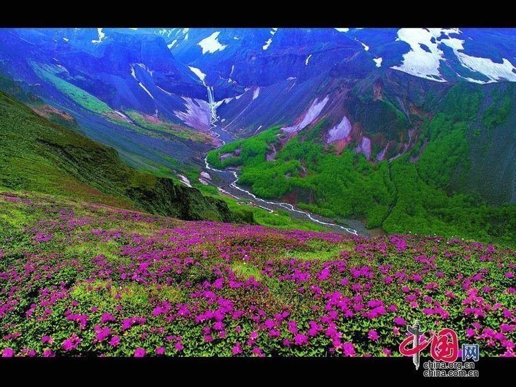
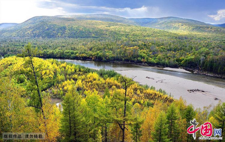
Heilongjiang is a land of varied topography. Much of the province is dominated by mountain ranges such as the Greater Khingan Range and Lesser Khingan Range, Zhangguangcai Mountains, Laoye Mountains, and Wanda Mountains. The highest peak is Mount Datudingzi at 1,690 metres (5,540 ft), located on the border with Jilin province. The Greater Khingan Range contains China's largest remaining virgin forest and is an important area for China's forestry industry.
The east and southwest of the province, which are relatively flat and low in altitude, contain the Muling River, the Naoli River, the Songhua River, the Nen River, and the Mudan River, all tributaries of the Amur, while the northern border forms part of the Amur valley. Xingkai Lake (or Khanka Lake) is found on the border with Russia's Primorsky Krai.
Climate
A humid continental climate (Köppen Dwa or Dwb) predominates in the province, though areas in the far north are subarctic (Köppen Dwc). Winters are long and bitter, with an average of −31 to −15 °C (−24 to 5 °F) in January, and summers are short and warm to very warm with an average of 18 to 23 °C (64 to 73 °F) in July. The annual average rainfall is 400 to 700 millimetres (16 to 28 in), concentrated heavily in summer. Clear weather is prevalent throughout the year, and in the spring, the Songnen Plain and the Sanpingjiang Plain provide abundant sources of wind energy.
The province's largest cities include Harbin, Qiqihar, Mudanjiang, Jiamusi, Daqing, Jixi, Shuangyashan, Hegang, Qitaihe, Yichun, and Heihe.
Transport
A road and highway proposal was accepted in 2006; the project plans to develop 38,000 kilometers of new roads and expand Heilongjiang’s total road network to 2.3 million kilometers.
There are 60 rail lines of around 5,300 kilometers including a section of the Asia-Europe Continental Bridge. The Harbin–Dalian High-Speed Railway, completed in 2012, stretches from Harbin, Heilongjiang’s capital, to Dalian in Liaoning province via Changchun and Shenyang comprising 23 stops. It is expected to transport 37 million passengers per year by 2020 and 51 million by 2030.
Major airports include Harbin Taiping International Airport, Qiqihar Airport, Mudanjiang Airport, Jiamusi Airport and Heihe Airport. Harbin International Airport is capable of handling six million passengers every year and connects to over 70 domestic and international cities.
Amur Bridge Project
The Amur Bridge Project was proposed in 2007 by Valery Solomonovich Gurevich, the vice-chairman of the Jewish Autonomous Oblast in Russia. The railway bridge over the Amur River will connect Tongjiang with Nizhneleninskoye, a village in the Jewish Autonomous Oblast.
The Chinese portion of the bridge was finished in July 2016. In December 2016, work began on the Russian portion of the bridge in December 2016. The bridge is expected to open in October 2019.
Administrative divisions
Heilongjiang is divided into thirteen prefecture-level divisions: twelve prefecture-level cities (including a sub-provincial city) and one prefecture:
(Additional information regarding the last prefecture can be found at Greater Khingan.)
The thirteen prefecture-level divisions of Heilongjiang are subdivided into 128 county-level divisions (65 districts, 19 county-level cities, 43 counties, and 1 autonomous county). Those are in turn divided into 1,284 township-level divisions (473 towns, 400 townships, 58 ethnic townships, and 353 subdistricts).
Politics
List of Secretaries of the CPC Heilongjiang Committee:
- Zhang Qilong 张启龙(1949–1950)
- Zhao Dezun 赵德尊 (1950–1953)
- Feng Jixin 冯纪新 (1953–1954)
- Ouyang Qin 欧阳钦 (1954–1965)
- Pan Fusheng 潘复生 (1965–1971)
- Wang Jiadao 汪家道 (1971–1974)
- Liu Guangtao 刘光涛 (1977)
- Yang Yichen 杨易辰 (1977–1983)
- Li Li'an 李力安 (1983–1985)
- Sun Weiben 孙维本 (1985–1994)
- Yue Qifeng 岳岐峰 (1994–1997)
- Xu Youfang 徐有芳 (1997–2003)
- Song Fatang 宋法棠 (2003–2005)
- Qian Yunlu 钱运录 (2005–2008)
- Ji Bingxuan 吉炳轩 (2008–2013)
- Wang Xiankui 王宪魁 (March 2013 – incumbent)
List of Governors:
- Yu Yifu 于毅夫 (1949–1952)
- Zhao Dezun 赵德尊 (1952–1953)
- Chen Lei 陈雷 (1953–1954)
- Han Guang 韩光 (1954–1956)
- Ouyang Qin 欧阳钦 (1956–1958)
- Li Fanwu 李范五 (1958–1966)
- Pan Fusheng 潘复生 (1967–1971)
- Wang Jiadao 汪家道 (1971–1974)
- Liu Guangtao 刘光涛 (February 1977 – December 1977)
- Yang Yichen 杨易辰(December 1977 – 1979)
- Chen Lei 陈雷 (1979–1985)
- Hou Jie 侯捷 (1985–1989)
- Shao Qihui 邵奇惠 (1989–1994)
- Tian Fengshan 田凤山(1994–2000)
- Song Fatang 宋法棠 (2000–2003)
- Zhang Zuoji 张左己 (2003 – December 2007)
- Li Zhanshu 栗战书 (December 2007 – August 2010)
- Wang Xiankui 王宪魁 (August 2010 – March 2013)
- Lu Hao 陆昊 (March 2013 – incumbent)
Economy
The agriculture of Heilongjiang, heavily defined by its cold climate, is based upon crops such as soybeans, maize, wheat and potatoes. Commercial crops grown include beets, flax, and sunflowers.
Heilongjiang is also an important source of lumber for China. Pine, especially the Korean pine and larch are the most important forms of lumber produced in Heilongjiang. Forests are mostly to be found in the Greater Khingan Mountains and Lesser Khingan Mountains, which are also home to protected animal species such as the Siberian tiger, the red-crowned crane, and the lynx.
Herding in Heilongjiang is centered upon horses and cattle; the province has the largest number of milk cows and the highest production of milk among all the province-level divisions of China.
Petroleum is of great importance in Heilongjiang, and the Daqing oilfields are an important source of petroleum for China. Coal, gold, and graphite are other important minerals to be found in Heilongjiang. Heilongjiang also has great potential for wind power, with an average wind energy density of 200 watts per square metre.
Heilongjiang is part of northeast China, the country's traditional industrial base. Industry is focused upon coal, petroleum, lumber, machinery, and food. Due to its location, Heilongjiang is also an important gateway for trade with Russia. Since a wave of privatization led to the closure of uncompetitive factories in the 1990s, Manchuria has suffered from stagnation. As a result, the government has started the Revitalize Northeast China campaign to deal with this problem, promoting the private sectors as the preferred method of economic reform.
At least five miners were killed after a coal mine fire in Heilongjiang it was reported on September 21, 2008.
Its GDP has been rising steadily since 2003, growing 37% from 2003 to 2007. The value of the private economy reached RMB234 billion in 2006 and accounted for 37.6 percent of the GDP. In that year, the tax revenue from private enterprises hit RMB20.5 billion.
Private enterprises in Heilongjiang led the overall economic growth of the province. Many leading private enterprises have begun to emerge. The province's three major private enterprises, namely the Heilongjiang Sunflower Medicine Ltd, Qitaihe Yidaxin Coal Co., and Heilongjiang Yiyang Group, each contributed more than RMB100 million in tax revenue in 2007.
During the first decade of this century, many private investors were involved in large construction projects in Heilongjiang. In 2006, 928 large projects absorbed private capital of RMB5 million each, and 101 projects attracted RMB100 million each within the province. In line with the central government’s policy to revitalize the Northeast, Heilongjiang also restructured its six pillar industries, namely equipment manufacturing, petrochemicals, food processing, energy, pharmaceuticals, and forest and timber processing.
In 2013, Heilongjiang's nominal GDP was 260.87 billion Chinese yuan, with an annual growth rate of 12.2%. Its per capita GDP was 21,640 yuan (US$3,168). Its primary, secondary, and tertiary industries were worth 108.9 billion yuan, 436.6 billion yuan, and 285.5 billion yuan respectively. The per capita disposable income of urban residents in Heilongjiang reached 11,581 yuan (US$1,667), a rise of 13% from the previous year. The per capita net income of rural residents in the province reached 4,856 yuan (US$700), a rise of 17.5 from 2007.
Economic and technological development zones
Demographics
The majority of Heilongjiang's population is Han Chinese, while other ethnic minorities include the Manchus, Koreans, Mongols, Hui, Xibe, and Hezhen
Excludes members of the People's Liberation Army in active service.
Source: Department of Population, Social, Science and Technology Statistics of the National Bureau of Statistics of China (国家统计局人口和社会科技统计司) and Department of Economic Development of the State Ethnic Affairs Commission of China (国家民族事务委员会经济发展司), eds. Tabulation on Nationalities of 2000 Population Census of China (《2000年人口普查中国民族人口资料》). 2 vols. Beijing: Nationalities Publishing House (民族出版社), 2003. (ISBN 7-105-05425-5)
Religion
Most of Heilongjiang's residents are either non-religious or practice Chinese folk religions, including Taoism. Manchu shamanism is practiced by many Manchu people. Chinese Buddhism and Tibetan Buddhism have an important presence in the province.
Culture
Heilongjiang's culture is part of a culture of Northeast China that is relatively homogeneous across this region, known in Mandarin Chinese as "Dongbei" (the northeast).
Media
Heilongjiang Television and Harbin Economy Radio serve as broadcasters.
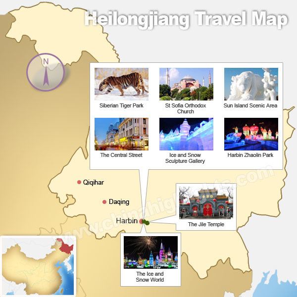
Tourism
Harbin, the provincial capital, is a city of contrasts, with Chinese, Russian, and eclectic worldwide influences clearly apparent. Bukui Mosque, a national heritage site, is the largest glazed tile building in the province. Eastern Orthodox, Roman Catholic, and Protestant churches as well as synagogues dot the city.
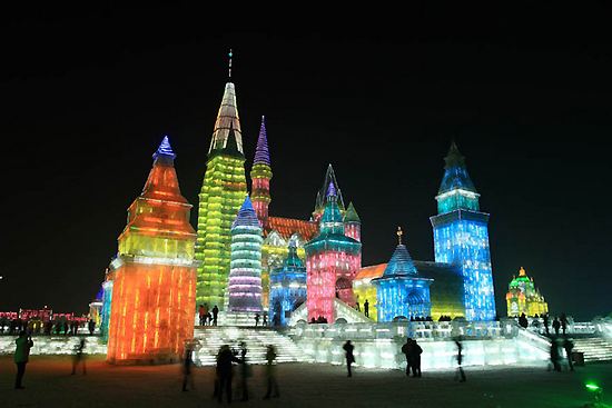
The long, cold winter is the backdrop for its famed ice sculpture exhibitions. In 2007 already the 8th Ice and Snow World opened to visitors in Harbin. More than 2000 ice sculptures were on display at the annual event.
Wudalianchi Lakes are a series of five lakes formed between 1719 and 1721 when volcanic eruption shaped one section of a tributary of the Amur into five interconnected lakes. The second lake in particular is renowned for its irregular geological sights.
Lake Jingbo, in Ning'an County, is a section of the Mudan River that has been narrowed and shaped by volcanic eruption into a series of sights, including the Diaoshuilou Falls.