
Type Highway | Length 202 km | |
 | ||
Major settlements Millmerran, Queensland, Pittsworth | ||
The Gore Highway is a highway in Queensland running between Toowoomba and Goondiwindi. Together with Goulburn Valley Highway and Newell Highway, it is a part of the National Highway's Melbourne-Brisbane link. It is signed as National Highway A39.
Contents
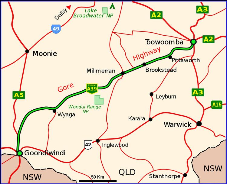
- Map of Gore Hwy Queensland Australia
- Speed Zones
- Towns and localities
- Toowoomba Second Range Crossing
- References
Map of Gore Hwy, Queensland, Australia
It is named after two brothers, George and Ralph Gore who established Yandilla station in the area (between Pittsworth and Milmerran), through which the road traverses.
It passes through Queensland's Darling Downs region. Typical of the scenery are grazing cattle, orchards and grain farmland. It was elevated to National Highway status in February 1993, and replaced the Cunningham Highway as the main route between Goondiwindi and Brisbane. Interstate traffic is rerouted through Toowoomba and the Warrego Highway as it presents a less steep gradient than via Warwick and Cunninghams Gap, shortening travel time especially for trucks. It was initially designated State Route 85 until February 1993 when National Highway 85 was proclaimed, splitting State Route 85 into two. In 2005 it was given the National Highway A39 designation.
Speed Zones
Towns and localities
Toowoomba Second Range Crossing
The Toowoomba Second Range Crossing is a major road proposal aimed at bypassing the urban area of Toowoomba and providing a better crossing of the Great Dividing Range. The bypass will link the Warrego Highway at Helidon (in the east) with Gore Highway at Athol (southwest of Toowoomba) via Charlton and will be 41 km in length.