
 | ||
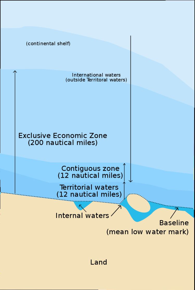
An exclusive economic zone (EEZ) is a sea zone prescribed by the United Nations Convention on the Law of the Sea over which a state has special rights regarding the exploration and use of marine resources, including energy production from water and wind. It stretches from the baseline out to 200 nautical miles (nmi) from its coast. In colloquial usage, the term may include the continental shelf. The term does not include either the territorial sea or the continental shelf beyond the 200 nmi limit. The difference between the territorial sea and the exclusive economic zone is that the first confers full sovereignty over the waters, whereas the second is merely a "sovereign right" which refers to the coastal state's rights below the surface of the sea. The surface waters, as can be seen in the map, are international waters.
Contents
Definition
Generally, a state's exclusive economic zone is an area beyond and adjacent to the territorial sea, extending seaward to a distance of no more than 200 nautical miles (370 km) out from its coastal baseline. The exception to this rule occurs when exclusive economic zones would overlap; that is, state coastal baselines are less than 400 nautical miles (740 km) apart. When an overlap occurs, it is up to the states to delineate the actual maritime boundary. Generally, any point within an overlapping area defaults to the nearest state.
A state's exclusive economic zone starts at the seaward edge of its territorial sea and extends outward to a distance of 200 nautical miles (370.4 km) from the baseline. The exclusive economic zone stretches much further into sea than the territorial waters, which end at 12 nmi (22 km) from the coastal baseline (if following the rules set out in the UN Convention on the Law of the Sea). Thus, the exclusive economic zones includes the contiguous zone. States also have rights to the seabed of what is called the continental shelf up to 350 nautical miles (648 km) from the coastal baseline, beyond the exclusive economic zones, but such areas are not part of their exclusive economic zones. The legal definition of the continental shelf does not directly correspond to the geological meaning of the term, as it also includes the continental rise and slope, and the entire seabed within the exclusive economic zone.
Origin
The idea of allotting nations EEZs to give them more control of maritime affairs outside territorial limits gained acceptance in the late 20th century.
Initially, a country's sovereign territorial waters extended 3 nautical miles or 6 km (range of cannon shot) beyond the shore. In modern times, a country's sovereign territorial waters extend to 12 nautical miles (~22 km) beyond the shore. One of the first assertions of exclusive jurisdiction beyond the traditional territorial seas was made by the United States in the Truman Proclamation of September 28, 1945. However, it was Chile and Peru respectively that first claimed maritime zones of 200 nautical miles with the Presidential Declaration Concerning Continental Shelf of 23 June 1947 (El Mercurio, Santiago de Chile, 29 June 1947) and Presidential Decree No. 781 of 1 August 1947 (El Peruano: Diario Oficial. Vol. 107, No. 1983, 11 August 1947).
It was not until 1982 with the UN Convention on the Law of the Sea that the 200 nautical mile exclusive economic zone was formally adopted as:
Part V, Article 55 of the Convention states:
The exclusive economic zone is an area beyond and adjacent to the territorial sea, subject to the specific legal regime established in this Part, under which the rights and jurisdiction of the coastal State and the rights and freedoms of other States are governed by the relevant provisions of this Convention.Disputes
The exact extent of exclusive economic zones is a common source of conflicts between states over marine waters.
Regions where a permanent ice shelf extends beyond the coastline are also a source of potential dispute.
Transboundary stocks
Fisheries management, usually adhering to guidelines set by the FAO, provides significant practical mechanisms for the control of EEZs. Transboundary fish stocks are an important concept in this control. Transboundary stocks are fish stocks that range in the EEZs of at least two countries. Straddling stocks, on the other hand, range both within an EEZ as well as in the high seas, outside any EEZ. A stock can be both transboundary and straddling.
Australia
Australia has the third largest exclusive economic zone, behind the United States and France, but ahead of Russia, with the total area actually exceeding that of its land territory. Per the UN convention, Australia's EEZ generally extends 200 nautical miles (370 km) from the coastline of Australia and its external territories, except where a maritime delimitation agreement exists with another state.
The United Nations Commission on the Limits of the Continental Shelf confirmed, in April 2008, Australia's rights over an additional 2.5 million square kilometres of seabed beyond the limits of Australia's EEZ. Australia also claimed, in its submission to the UN Commission on the Limits of the Continental Shelf, additional Continental Shelf past its EEZ from the Australian Antarctic Territory, but these claims were deferred on Australia's request. However, Australia's EEZ from its Antarctic Territory is approximately 2 million square kilometres.
Brazil
Brazil's EEZ includes areas around the Fernando de Noronha Islands, St Paul and St. Peter Archipelago and the Trindade and Martim Islands.
In 2004, the country submitted its claims to the United Nations Commission on the Limits of the Continental Shelf (CLCS) to extend its maritime continental margin.
Canada
Canada is unusual in that its exclusive economic zone, covering 2,755,564 km2, is slightly smaller than its territorial waters. The latter generally extend only 12 nautical miles from the shore, but also include inland marine waters such as Hudson Bay (about 300 nautical miles (560 km; 350 mi) across), the Gulf of Saint Lawrence and the internal waters of the Arctic archipelago.
Chile
Chile's EEZ includes areas around the Desventuradas Islands, Easter Island and the Juan Fernández Islands.
There is a dispute with Peru over the extent of Chile's EEZ: Chilean–Peruvian maritime dispute
China
The first figure excludes all disputed waters, while the last figure indicates China's claimed boundaries, and does not take into account neighboring powers' claims.
Cyprus
The Exclusive Economic Zone of Cyprus covers more than 70,000 km2 and is divided between 13 exploration blocks. The process of the establishment of Cyprus, Israel and Lebanon Exclusive Economic Zones was held in Nicosia in 2010 with separate meetings between each country. Cyprus and Israel as part of their wider cooperation have agreed to start their gas explorations with a common American company, specifically Noble Energy. Cypriot and Israeli governments are discussing to export their natural gas through the shipping of compressed Natural Gas to Greece and then to the rest of Europe or through a subsea Pipelines starting from Israel and then leading to Greece via Cyprus.
Denmark
The Kingdom of Denmark includes the constituent country (selvstyre) of Greenland and the constituent country (hjemmestyre) of the Faroe Islands.
France
Due to its numerous Overseas departments and territories scattered on all oceans of the planet, France possesses the largest EEZ in the world, covering 11,691,000 km2 (4,514,000 mi2), the EEZ of the United States is the second largest (11,351,000 km2 / 4,382,000 mi2). The EEZ of France covers approximately 8% of the total surface of all the EEZs of the world, whereas the land area of the French Republic is only 0.45% of the total land area of the Earth.
Greece
Greece has claimed an exclusive economic zone, as it is entitled to do so, as per UNCLOS 1982 as well as customary international law.
According to published maps, the Israeli government has recognized the Exclusive Economic Zones (EEZ) of Greece and Cyprus. They describe the course of the gas pipeline which will transfer gas produced by American Νoble Εnergy Ltd. from the Leviathan reservoir to Europe, through an undersea pipeline crossing Greece. The gas pipeline should traverse the sea area, which according to international law, is part of the Greek EEZ. By this proposal, Israel recognizes the Greek EEZ in the area and offers an advantage that Greece can use during negotiation procedures to support its claims on the area. In practice, this cooperation will set up a powerful energy coalition between Greece, Cyprus and Israel. The mining and operating part will be undertaken by an American company. "The substance of the issue is that in an effort to protect and secure vital Israeli interests in the Mediterranean Sea, Israel has been left with no choice other than to officially delimit its maritime borders".
India
India is currently seeking to extend its EEZ to 350 miles.
Israel
In 2010, an agreement was signed with Cyprus concerning the limit of territorial waters between Israel and Cyprus at the maritime halfway point, a clarification essential for safeguarding Israel's rights to oil and underwater gas reservoirs. The agreement was signed in Nicosia by Israeli Infrastructure Minister Uzi Landau and the Cypriot Foreign Minister Markos Kyprianou. The two countries agreed to cooperate in the development of any cross border resources discovered, and to negotiate an agreement on dividing joint resources, however this area is not a true EEZ as described in the UNCLOS.
Japan
Japan has disputes over its EEZ boundaries with all its Asian neighbors (Russia, Republic of Korea, China and Taiwan). The above, and relevant maps at the Sea Around Us Project both indicate Japan's claimed boundaries, and do not take into account neighboring powers' claims.
Japan also refers to various categories of "shipping area" – Smooth Water Area, Coasting Area, Major or Greater Coasting Area, Ocean Going Area – but it is unclear whether these are intended to have any territorial or economic implications.
Mexico
Mexico's exclusive economic zones comprise a total surface area of 3,144,295 km2, and places Mexico among the countries with the largest areas in the world.
New Zealand
New Zealand's EEZ covers 4,083,744 km2, which is approximately fifteen times the land area of the country. Sources vary significantly on the size of New Zealand's EEZ; for example, a recent government publication gave the area as roughly 4,300,000 km2. These figures are for the EEZ of New Zealand proper, and do not include the EEZs of other territories in the Realm of New Zealand (Tokelau, Niue, the Cook Islands and the Ross Dependency).
Norway
Norway has a large exclusive economic zone of 819 620 km2 around its coast. The country has a fishing zone of 1,878,953 km2, including fishing zones around Svalbard and Jan Mayen.
In April 2009, the United Nations Commission for the Limits of the Continental Shelf approved Norway's claim to an additional 235,000 square kilometres of continental shelf. The commission found that Norway and Russia both had valid claims over a portion of shelf in the Barents Sea.
Philippines
The Philippines' EEZ covers 2,263,816 km2
Poland
The Polish EEZ covers the area of 30,533 km2 within the Baltic Sea.
Portugal
Portugal has the 10th largest EEZ in the world. Presently, it is divided in three non-contiguous sub-zones:
Portugal submitted a claim to extend its jurisdiction over additional 2.15 million square kilometers of the neighboring continental shelf in May 2009, resulting in an area with a total of more than 3,877,408 km2. The submission, as well as a detailed map, can be found in the Task Group for the extension of the Continental Shelf website.
Spain disputes the EEZ's southern border, maintaining that it should be drawn halfway between Madeira and the Canary Islands. But Portugal exercises sovereignty over the Savage Islands, a small archipelago north of the Canaries, claiming an EEZ border further south. Spain objects, arguing that the Savage Islands do not have a separate continental shelf, citing article 121 of the United Nations Convention on the Law of the Sea.
Russia
Somalia
South Africa
South Africa's EEZ includes both that next to the African mainland and that around the Prince Edward Islands, totalling 1,535,538 km2.
South Korea
Area: 300,851 (225,214) km2
United Kingdom
The United Kingdom's exclusive economic zone is the fifth largest in the world at 6,805,586 square km. It comprises the exclusive economic zones surrounding the United Kingdom, the Crown Dependencies, and the British Overseas Territories. The figure does not include the EEZ of the British Antarctic Territory. The exclusive economic zones associated with the Falkland Islands and South Georgia are disputed by Argentina.
Only the United Kingdom and Gibraltar are part of the EU. The Channel Islands, the Isle of Man and the remaining overseas territories (that is, all except Gibraltar) are not part of the EU. The United Kingdom has not as yet claimed its rights with regards to Gibraltar or the Sovereign Base Areas in Cyprus.
†Part of the overseas territory of Saint Helena, Ascension and Tristan da Cunha, which together has an EEZ of 1,641,294 square km.
United States
The United States' exclusive economic zone is the second largest in the world, covering 11,351,000 km2. Areas of its EEZ are located in three oceans, the Gulf of Mexico, and the Caribbean Sea.
The sizes of the components of the US EEZ/territorial seas are (in decreasing size):
Total: 11,351,000 km2 (4,383,000 sq mi)
Rankings by area
This list includes dependent territories within their sovereign states (including uninhabited territories), but does not include claims on Antarctica. EEZ+TIA is exclusive economic zone (EEZ) plus total internal area (TIA).