
Area 920 km² Established November 28, 1986 | Phone +886 3 862 1100 | |
 | ||
Hours Open today · 8:30AM–5PMMonday8:30AM–5PMTuesday8:30AM–5PMWednesday8:30AM–5PMThursday8:30AM–5PMFriday8:30AM–5PMSaturday8:30AM–5PMSunday8:30AM–5PMSuggest an edit Similar Qingshui Cliff, Qixingtan Beach, Sun Moon Lake, Hehuanshan, Tianxiang Scenic Area Profiles | ||
Taroko National Park (Chinese: 太魯閣國家公園; pinyin: Tàilǔgé gúojiā gōngyuán; Pe̍h-ōe-jī: Taroko kok-ka kong-hn̂g) is one of the nine national parks in Taiwan and was named after the Taroko Gorge, the landmark gorge of the park carved by the Liwu River. The park spans Taichung Municipality, Nantou County, and Hualien County.
Contents
- Riding through taroko gorge in taroko national park
- Origin of the nameEdit
- GeologyEdit
- TransportationEdit
- References
The park was originally established as the Tsugitaka-Taroko National Park (Japanese: 次高タロコ国立公園, Hepburn: Tsugitaka Taroko kokuritsu kōen) by the Governor-General of Taiwan on 12 December 1937 when Taiwan was part of the Empire of Japan. After the Empire of Japan's defeat in World War II, the Republic of China assumed control of Taiwan. The ROC government subsequently abolished the park on 15 August 1945. It was not until 28 November 1986 that the park was reestablished.
Sights include:
Riding through taroko gorge in taroko national park
Origin of the nameEdit
The name, Taroko (formally as Truku), means "human being" in the Truku language of the Truku indigenous tribe. While most attribute the name Taroko to the Truku tribe which settled here from the Nantou region near Sun Moon Lake, some other more obscure stories have been noted.
GeologyEdit
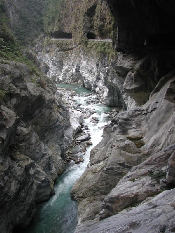
Taroko Gorge and its surrounding area are well known for their abundant supply of marble, leading to its nickname, "The Marble Gorge". The rock now seen in Taroko began over 200 million years ago as sediment on the bottom of the ocean. As the sediment collected, it was subject to increasingly large amounts of pressure which eventually hardened it into limestone. Over the past 100 million years, tectonic compression between the Philippine Sea Plate and the Eurasian Plate supplied additional pressure that metamorphosed the limestone into marble. Uplifting forces from the plate collision pushed this rock above the surface of the ocean to where we see it today. The region is still being uplifted by approximately 0.5 cm (half-centimeter) per year.
The gorge itself was carved into the marble by the erosive power of the Liwu River.
In addition, there is known to be jade in this gorge. This jade is only found in Taiwan and it supplies the jade market in Hualien. These mountains can be seen rafting (a common activity during summer months in Taroko Gorge) through the rivers.
The Tupido Tribe Trail was built by the Batto Bulego family of Taroko some 120 years ago, and now only parts of its ruins remain on the Tienhsyang Taiti mesa (天祥台地). Four generations of the family resided there until the Japanese army massacred the tribe and banished the survivors in 1914.
TransportationEdit
Taroko National Park is accessible West from Xincheng Station of the Taiwan Railways Administration.