
Simplified Chinese 南海 Hanyu Pinyin Hanyu Pinyin Area 3.5 million km² | Traditional Chinese 南海 Literal meaning South Sea Bopomofo ㄋㄢˊ ㄏㄞˇ Bridges Nan'ao Bridge | |
 | ||
Islands Scarborough Shoal, Woody Island, Taiping Island | ||
The South China Sea is a marginal sea that is part of the Pacific Ocean, encompassing an area from the Karimata and Malacca Straits to the Strait of Taiwan of around 3,500,000 square kilometres (1,400,000 sq mi). The area's importance largely results from one-third of the world's shipping sailing through its waters and that it is believed to hold huge oil and gas reserves beneath its seabed.
Contents
- Map of South China Sea
- Facts
- chexit south china sea japan to provide f 35 maintenance sites in pacific region
- Names
- Geography
- Extent
- Geology
- Islands and seamounts
- Territorial claims
- 2016 ruling
- References
Map of South China Sea
It is located
The minute South China Sea Islands, collectively an archipelago, number in the hundreds. The sea and its mostly uninhabited islands are subject to competing claims of sovereignty by several countries. These claims are also reflected in the variety of names used for the islands and the sea.
Facts
chexit south china sea japan to provide f 35 maintenance sites in pacific region
Names
South China Sea is the dominant term used in English for the sea, and the name in most European languages is equivalent. This name is a result of early European interest in the sea as a route from Europe and South Asia to the trading opportunities of China. In the sixteenth century Portuguese sailors called it the China Sea (Mare da China); later needs to differentiate it from nearby bodies of water led to calling it the South China Sea. The International Hydrographic Organization refers to the sea as "South China Sea (Nan Hai)".
The Yizhoushu, which was a chronicle of the Western Zhou dynasty (1046–771 BCE) gives the first Chinese name for the South China Sea as Nanfang Hai (Chinese: 南方海; pinyin: Nánfāng Hǎi; literally: "Southern Sea"), claiming that barbarians from that sea gave tributes of hawksbill sea turtles to the Zhou rulers. The Classic of Poetry, Zuo Zhuan, and Guoyu classics of the Spring and Autumn period (771–476 BCE) also referred to the sea, but by the name Nan Hai (Chinese: 南海; pinyin: Nán Hǎi; literally: "South Sea") in reference to the State of Chu's expeditions there. Nan Hai, the South Sea, was one of the Four Seas of Chinese literature. There are three other seas, one for each of the four cardinal directions. During the Eastern Han dynasty (23–220 CE), China's rulers called the Sea Zhang Hai (Chinese: 漲海; pinyin: Zhǎng Hǎi; literally: "distended sea"). Fei Hai (Chinese: 沸海; pinyin: Fèi Hǎi; literally: "boil sea") became popular during the Southern and Northern Dynasties period. Usage of the current Chinese name, Nan Hai (South Sea), became gradually widespread during the Qing Dynasty.
In Southeast Asia it was once called the Champa Sea or Sea of Cham, after the maritime kingdom of Champa that flourished there before the sixteenth century. The majority of the sea came under Japanese naval control during World War II following the military acquisition of many surrounding South East Asian territories in 1941. Japan calls the sea Minami Shina Kai "South China Sea". This was written 南支那海 until 2004, when the Japanese Foreign Ministry and other departments switched the spelling 南シナ海, which has become the standard usage in Japan.
In China, it is called the "South Sea", 南海 Nánhǎi, and in Vietnam the "East Sea", Biển Đông. In Malaysia, Indonesia and the Philippines, it was long called the "South China Sea" (Dagat Timog Tsina in Tagalog, Laut China Selatan in Malay), with the part within Philippine territorial waters often called the "Luzon Sea", Dagat Luzon, by the Philippines. However, following an escalation of the Spratly Islands dispute in 2011, various Philippine government agencies started using the name "West Philippine Sea". A PAGASA spokesperson said that the sea to the east of the Philippines will continue to be called the Philippine Sea.
In September 2012, Philippine President Benigno Aquino III signed Administrative Order No. 29, mandating that all government agencies use the name "West Philippine Sea" to refer to the parts of the South China Sea within the Philippines' exclusive economic zone, and tasked the National Mapping and Resource Information Authority (NAMRIA) to use the name in official maps.
Geography
States and territories with borders on the sea (clockwise from north) include: the People's Republic of China (including Macau and Hong Kong), the Republic of China (Taiwan), the Philippines, Malaysia, Brunei, Indonesia, Singapore, and Vietnam.
Major rivers that flow into the South China Sea include the Pearl, Min, Jiulong, Red, Mekong, Rajang, Pahang, Pampanga, and Pasig Rivers.
Extent
The International Hydrographic Organization defines the limits of the South China Sea as follows:
On the South. The Eastern and Southern limits of Singapore and Malacca Straits [A line joining Tanjong Datok, the Southeast point of Johore (1°22′N 104°17′E) through Horsburgh Reef to Pulo Koko, the Northeastern extreme of Bintan Island (1°13.5′N 104°35′E). The Northeastern coast of Sumatra] as far West as Tanjong Kedabu (1°06′N 102°58′E) down the East coast of Sumatra to Lucipara Point (3°14′S 106°05′E) thence to Tanjong Nanka, the Southwest extremity of Banka Island, through this island to Tanjong Berikat the Eastern point (2°34′S 106°51′E), on to Tanjong Djemang (2°36′S 107°37′E) in Billiton, along the North coast of this island to Tanjong Boeroeng Mandi (2°46′S 108°16′E) and thence a line to Tanjong Sambar (3°00′S 110°19′E) the Southwest extreme of Borneo.
On the East. From Tanjong Sambar through the West coast of Borneo to Tanjong Sampanmangio, the North point, thence a line to West points of Balabac and Secam Reefs, on to the West point of Bancalan Island and to Cape Buliluyan, the Southwest point of Palawan, through this island to Cabuli Point, the Northern point thereof, thence to the Northwest point of Busuanga and to Cape Calavite in the island of Mindoro, to the Northwest point of Lubang Island and to Point Fuego (14°08'N) in Luzon Island, through this island to Cape Engano, the Northeast point of Luzon, along a line joining this cape with the East point of Balintang Island (20°N) and to the East point of Y'Ami Island (21°05'N) thence to Garan Bi, the Southern point of Taiwan (Formosa), through this island to Santyo (25°N) its North Eastern Point.
On the North. From Fuki Kaku the North point of Formosa to Kiushan Tao (Turnabout Island) on to the South point of Haitan Tao (25°25'N) and thence Westward on the parallel of 25°24' North to the coast of Fukien.
On the West. The Mainland, the Southern limit of the Gulf of Thailand and the East coast of the Malay Peninsula.
Geology
The sea lies above a drowned continental shelf; during recent ice ages global sea level was hundreds of metres lower, and Borneo was part of the Asian mainland.
The South China Sea opened around 45 million years ago when the "Dangerous Ground" rifted away from southern China. Extension culminated in seafloor spreading around 30 million years ago, a process that propagated to the SW resulting in the V-shaped basin we see today. Extension ceased around 17 million years ago. Arguments have continued about the role of tectonic extrusion in forming the basin. Paul Tapponnier and colleagues have argued that as India collides with Asia it pushes Indochina to the SE. The relative shear between Indochina and China caused the South China Sea to open. This view is disputed by geologists who do not consider Indochina to have moved far relative to mainland Asia. Marine geophysical studies in the Gulf of Tonkin by Peter Clift has shown that the Red River Fault was active and causing basin formation at least by 37 million years ago in the NW South China Sea, consistent with extrusion playing a part in the formation of the sea. Since opening the South China Sea has been the repository of large sediment volumes delivered by the Mekong River, Red River and Pearl River. Several of these deltas are rich in oil and gas deposits.
Islands and seamounts
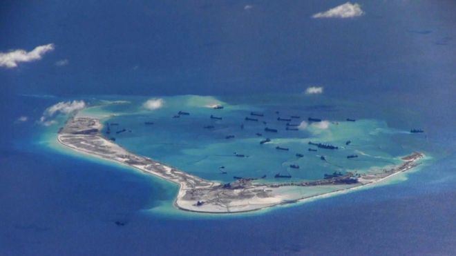
The South China Sea contains over 250 small islands, atolls, cays, shoals, reefs, and sandbars, most of which have no indigenous people, many of which are naturally under water at high tide, and some of which are permanently submerged. The features are grouped into three archipelagos (listed by area size), Macclesfield Bank and Scarborough Shoal:
The Spratly Islands spread over an 810 by 900 km area covering some 175 identified insular features, the largest being Taiping Island (Itu Aba) at just over 1.3 km long and with its highest elevation at 3.8 metres.
The largest singular feature in the area of the Spratly Islands is a 100 km wide seamount called Reed Tablemount, also known as Reed Bank, in the northeast of the group, separated from Palawan Island of the Philippines by the Palawan Trench. Now completely submerged, with a depth of 20 m, it was an island until it sank about 7,000 years ago due to the increasing sea level after the last ice age. With an area of 8,866 km², it is one of the largest submerged atoll structures in the world.
Territorial claims
Several countries have made competing territorial claims over the South China Sea. Such disputes have been regarded as Asia's most potentially dangerous point of conflict. Both People's Republic of China (PRC) and the Republic of China (ROC, commonly known as Taiwan) claim almost the entire body as their own, demarcating their claims within what is known as the nine-dotted line, which claims overlap with virtually every other country in the region. Competing claims include:
China and Vietnam have both been vigorous in prosecuting their claims. China (various governments) and South Vietnam each controlled part of the Paracel Islands before 1974. A brief conflict in 1974 resulted in 18 Chinese and 53 Vietnamese deaths, and China has controlled the whole of Paracel since then. The Spratly Islands have been the site of a naval clash, in which over seventy Vietnamese sailors were killed just south of Chigua Reef in March 1988. Disputing claimants regularly report clashes between naval vessels.
ASEAN in general, and Malaysia in particular, has been keen to ensure that the territorial disputes within the South China Sea do not escalate into armed conflict. As such, Joint Development Authorities have been set up in areas of overlapping claims to jointly develop the area and dividing the profits equally without settling the issue of sovereignty over the area. This is true, particularly in the Gulf of Thailand. Generally, China has preferred to resolve competing claims bi-laterally, while some ASEAN countries prefer multi-lateral talks, believing that they are disadvantaged in bi-lateral negotiations with the much larger China and that because many countries claim the same territory only multilateral talks could effectively resolve the competing claims.
The overlapping claims over Pedra Branca or Pulau Batu Putih including neighboring Middle Rocks by both Singapore and Malaysia were settled in 2008 by the International Court of Justice, awarding Pedra Branca/Pulau Batu Puteh to Singapore and Middle Rocks to Malaysia.
In July 2010, US Secretary of State Hillary Clinton called for the People's Republic of China to resolve the territorial dispute. China responded by demanding the US keep out of the issue. This came at a time when both countries have been engaging in naval exercises in a show of force to the opposing side, which increased tensions in the region. The US Department of Defense released a statement on August 18 where it opposed the use of force to resolve the dispute, and accused China of assertive behaviour. On July 22, 2011, one of India's amphibious assault vessels, the INS Airavat which was on a friendly visit to Vietnam, was reportedly contacted at a distance of 45 nautical miles from the Vietnamese coast in the disputed South China Sea on an open radio channel by a vessel identifying itself as the Chinese Navy and stating that the ship was entering Chinese waters. The spokesperson for the Indian Navy clarified that as no ship or aircraft was visible from INS Airavat it proceeded on her onward journey as scheduled. The Indian Navy further clarified that "[t]here was no confrontation involving the INS Airavat. India supports freedom of navigation in international waters, including in the South China Sea, and the right of passage in accordance with accepted principles of international law. These principles should be respected by all."
In September 2011, shortly after China and Vietnam had signed an agreement seeking to contain a dispute over the South China Sea, India's state-run explorer, Oil and Natural Gas Corporation (ONGC) said that its overseas investment arm ONGC Videsh Limited had signed a three-year deal with PetroVietnam for developing long-term cooperation in the oil sector and that it had accepted Vietnam's offer of exploration in certain specified blocks in the South China Sea. In response, Chinese Foreign Ministry spokesperson Jiang Yu issued a protest. The spokesman of the Ministry of External Affairs of the Government of India responded by saying that “The Chinese had concerns but we are going by what the Vietnamese authorities have told us and have conveyed this to the Chinese.” The Indo-Vietnamese deal was also denounced by the Chinese state-run newspaper Global Times.
In 1999, Taiwan claimed the entirety of the South China Sea islands under the Lee Teng-hui administration. The entire subsoil, seabed and waters of the Paracels and Spratlys are claimed by Taiwan.
In 2012 and 2013, Vietnam and Taiwan butted heads against each due over anti-Vietnamese military exercises by Taiwan.
In May 2014, China established an oil rig near the Paracel Islands, leading to multiple incidents between Vietnamese and Chinese ships.
In 2017, analysts expect the US, under Donald Trump's administration, to take a more aggressive stance against China in the South China Sea.
2016 ruling
In January 2013, the Philippines formally initiated arbitration proceedings against China's claim on the territories within the "nine-dash line" that includes Spratly Islands, which it said is unlawful under the United Nations Convention on the Law of the Sea (UNCLOS). On July 12, 2016, the arbitral tribunal backed the Philippines, saying that there was no evidence that China had historically exercised exclusive control over the waters or resources, hence there was "no legal basis for China to claim historic rights" over the nine-dash line. The tribunal also criticized China's land reclamation projects and its construction of artificial islands in the Spratly Islands, saying that it had caused "severe harm to the coral reef environment". It also characterized Taiping Island and other features of the Spratly Islands as "rocks" under UNCLOS, and therefore are not entitled to a 200 nautical mile exclusive economic zone. China however rejected the ruling, calling it "ill-founded". Taiwan, which currently administers Taiping Island, the largest of the Spratly Islands, also rejected the ruling.