
Length 187.7 km | ||
 | ||
Existed: 1964 renumbering (from US 6) – present South end: | ||
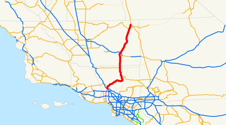
State Route 14 (SR 14) is a north–south state highway in the U.S. state of California, largely in the Mojave Desert. The southern portion of the highway is signed as the Antelope Valley Freeway. The route connects Interstate 5, or Golden State Freeway, on the border of the city of Santa Clarita to the north and the Los Angeles neighborhoods of Granada Hills and Sylmar to the south, with U.S. Route 395 near Inyokern. Legislatively, the route extends south of I-5 to State Route 1 in the Pacific Palisades area of Los Angeles, however the portion south of the junction with I-5 has not been constructed. The southern part of the constructed route is a busy commuter freeway serving and connecting the cities of Santa Clarita, Palmdale, and Lancaster with the rest of the Greater Los Angeles area. The northern portion, from Vincent (south of Palmdale) to Route 395, is legislatively named the Aerospace Highway, as the highway serves Edwards Air Force Base, once one of the primary landing strips for NASA's Space Shuttle. This section is rural, following the line between the hot Mojave desert and the forming Sierra Nevada mountain range. Most of Route 14 is loosely paralleled by a main line of the Southern Pacific Railroad, used for the Antelope Valley Line of the Metrolink commuter rail system as well as a connection between Los Angeles and the Central Valley via Tehachapi Pass.
Contents
- Map of CA 14 California USA
- Antelope Valley Freeway
- Aerospace Highway
- Trails
- US Route 6
- Incidents
- Cancelled plans
- Future
- Major intersections
- References
Map of CA-14, California, USA
Linked with US 395, this road connects Los Angeles with such places as Mammoth Mountain, Mono Lake, Yosemite National Park and Reno, Nevada. Route 14 was part of U.S. Route 6 prior to truncation in 1964, when U.S. 6 was a coast-to-coast route from Long Beach to Provincetown, Massachusetts. The non-freeway segment of SR 14 from Silver Queen Road north of Rosamond to Mojave is known as Sierra Highway, as is the old routing between Interstate 5 and Silver Queen Road where SR 14 has been moved to a newer freeway alignment. Portions of Route 14 remain signed with names associated with US 6, including Midland Trail, Theodore Roosevelt Highway and Grand Army of the Republic Highway. This route is part of the California Freeway and Expressway System.
Antelope Valley Freeway
The southern portion of the freeway, from Interstate 5 to the Avenue D exit near Lancaster, has been designated the Antelope Valley Freeway by the state legislature. The Antelope Valley Freeway begins in the Santa Susana Mountains at the Newhall Pass interchange by splitting from the Golden State Freeway (Interstate 5). This is the busiest portion of the route with an annual average daily traffic (AADT) count of 169,000 vehicles per day. The freeway forms the eastern boundary of Santa Clarita along its route. Past Santa Clarita, the road continues to the northeast and crosses the Sierra Pelona Mountains and western San Gabriel Mountains via the canyon of the seasonal Santa Clara River. The ascent is mostly rugged and rural terrain, with only two small towns along the ascent, first Agua Dulce and later Acton. Between the two towns the freeway forms the southern boundary of Vasquez Rocks Park, a county park. The highway crests the Sierra Pelona Mountains via Escondido Summit, at an elevation of 3,258 feet (993 m), before descending and passing by Acton to the north. The highway then crests the San Gabriel Mountains via Soledad Pass, at an elevation of 3,209 feet (978 m). The route of the highway through the mountains loosely parallels that of the main line of the Southern Pacific Railroad, which is also used for the Metrolink Antelope Valley Line.
After cresting both mountain passes, the highway descends into the Antelope Valley, a large valley within the Mojave Desert. The highway crosses Angeles Forest Highway and the California Aqueduct in the descent. Route 14 serves as the primary north–south thoroughfare for the communities of Palmdale and Lancaster. Between Palmdale Boulevard (County Route N2) and Avenue D in Lancaster, SR 14 runs concurrently with SR 138.
Aerospace Highway
From the Pearblossom Highway exit south of Palmdale to its northern terminus at Route 395 near Inyokern, SR 14 has been designated the Aerospace Highway. Between Pearblossom Highway and Avenue S, there is a vista point overlooking Lake Palmdale, which features a historic plaque that honors aviation accomplishments including the space shuttle, breaking the sound barrier and the speed record. The freeway passes the Los Angeles/Kern County line at Avenue A, and continues to run north through Rosamond and Mojave. In Rosamond, the highway passes close to Edwards Air Force Base, which was often used as one of the main landing strips for NASA's Space Shuttle, and as the base for the X-15 and many other air and spacecraft.
The freeway portion terminates just south of Mojave, where SR 14 serves as the main street and runs through the downtown area. To the east of the route is Mojave Air & Space Port, home to the National Test Pilot School and SpaceShipOne, the first privately funded human spaceflight, as well as a vast airplane graveyard; all are visible from Route 14.
State Route 58 was formerly routed concurrent with SR 14 through Mojave, before it was rerouted onto a bypass running north and east of the town.
The character of the highway changes as it leaves Mojave. The road, now a divided highway with at-grade intersections, departs the corridor of the main Southern Pacific Line, to follow the crest of the forming Sierra Nevada mountains. The route continues to follow a branch line of the Southern Pacific used as a connector for the Trona Railway. The main line of the railroad proceeds towards the Central Valley via Tehachapi Pass. Though Route 14 heads away from the pass, the highway has views of the mountains and the Tehachapi Pass Wind Farm. The scenery also changes, as the highway departs the Mojave Desert and crosses Red Rock Canyon State Park. Traffic counts drop dramatically as the highway becomes more rural, with an AADT of 3200 vehicles at the northern terminus. SR 14 continues north toward U.S. Route 395 in Inyokern, much of its routing as an expressway. Towards its northern terminus, SR 14 runs briefly concurrent with State Route 178. At its northern terminus, SR 14 merges with US 395 as it turns into an expressway heading north to Bishop. As US 395 the route continues to follow the crest of the Sierra Nevada, serving Owens Valley, Mammoth Mountain, Yosemite National Park and Mono Lake.
Trails
The first road to use the general alignment of modern Route 14 was called the El Camino Sierra, or Sierra Highway, which extended from Los Angeles to Lake Tahoe. A dirt road was completed in the 1910s from what had been a pack trail. The Los Angeles Times declared El Camino Sierra complete in 1931, when the portion from Mojave to the Owens Valley, along modern US 395, was paved.
During the late 19th century, the corridor of modern Route 14 was also in use by the Southern Pacific Railroad for two lines. The first is a line to connect Los Angeles with the Central Valley, via Tehachapi Pass. While significantly longer than the more direct Ridge Route (east of modern Interstate 5), Tehachapi Pass is lower than Tejon Pass along the Ridge Route, with a longer, less steep grade on the descent into the Central Valley. This rail line remains the primary rail line to connect southern and northern California in use today, now owned and operated by the Union Pacific Railroad. The second resulted when the Southern Pacific acquired the un-finished Carson and Colorado Railroad in 1900. The Southern Pacific built a standard gauge connector to the narrow gauge Carson and Colorado line from their main at Mojave. Although plans were to eventually convert this acquired line to standard gauge, most of the line was abandoned before the conversion was complete. However, the southern portion of this line is still active and used for connections to the Trona Railway.
The Midland Trail was one of the first organized coast-to-coast trails in the United States. In the trail's infancy, its routing changed numerous times. By 1925, the Midland Trail was established along what is modern State Route 168, joining El Camino Sierra in Big Pine. Other named trails that would eventually follow this route included the Theodore Roosevelt highway, and Grand Army of the Republic Highway. Parts of modern Route 14 continue to be signed with these names, and north of Los Angeles County is still officially designated "El Camino Sierra / Midland Trail" as well as the aforementioned "Aerospace Highway".
U.S. Route 6
U.S. Route 6 was extended from Greeley, Colorado to Long Beach, California on June 21, 1937. Most of this extension used the Midland Trail, although the route entered California from Nevada slightly north of the previous route of the Midland Trail, instead passing through Bishop. While being designated US 6, parts of modern Route 14 began to be upgraded to freeway standards.
As part of the 1964 state highway renumbering, US 6 was truncated at Bishop. The portion of US 6 from Inyokern to Los Angeles was designated State Route 14. Previously the Route 14 designation was used for Artesia Boulevard and Lincoln Avenue, in the Los Angeles area, a portion of modern State Route 91.
Between 1963 and 1975 significant portions of US 6/SR 14 were moved to a freeway alignment. The former routing south of Mojave (and the current routing to the north) is still known as Sierra Highway. The first freeway section, from just east of Solemint Junction to Red Rover Mine Road, was completed in 1963. Further portions in the intercanyon areas of Acton to Soledad Pass were completed by 1965. By 1966 the freeway was complete as far north as Avenue P-8 in Palmdale. The freeway was completed to Mojave by 1972.
Incidents
The Newhall Pass interchange, where I-5, Sierra Highway, Foothill Boulevard, San Fernando Road and the southern terminus of Route 14 meet, has been the site of a number of catastrophic incidents. The interchange has partially collapsed twice due to earthquakes; the 1971 Sylmar earthquake and the 1994 Northridge earthquake. As a result of the 1994 collapse this intersection was renamed the "Clarence Wayne Dean Memorial Interchange", honoring a Los Angeles Police Department motorcycle officer killed when he was unable to stop in time and drove off the collapsed flyover ramp from SR 14 south to I-5 south. After both earthquakes, the collapsed portions were rebuilt and surviving portions reinforced.
In 2007, two tractor-trailer trucks collided in a tunnel along the truck lanes for southbound I-5 at the interchange. A resulting fire started, soon encompassing the entire tunnel along with 30 other trucks and one passenger vehicle that were in the tunnel at the time. The truck tunnel was closed for several days for structural damage inspections and repairs.
Cancelled plans
Route 14 is an unfinished route, as the definition in the California Streets and Highways Code states that the route begins at State Route 1 (Pacific Coast Highway), near Sunset Blvd. in the Pacific Palisades area of Los Angeles. Between the constructed end and legislative end of Route 14 is the area of Los Angeles called Reseda and Topanga State Park. There is no paved road that directly connects these two points, with State Route 27 or Interstate 405 being the nearest through roads in this area.
The intersection of Route 14 with Via Princessa in Santa Clarita is an unusual design, with long flyover ramps for the connections. This is the result of a freeway revolt by the residents of Santa Clarita, that canceled plans for a freeway extension of Route 126. While the Via Princessa alignment of Route 126 was canceled, a different alignment is being constructed with proposed connections to Route 14.
Future
Rapid exurban growth in Santa Clarita, Lancaster, and Palmdale has made the Antelope Valley Freeway one of the most congested in southern California, with average rush hour speeds well below 20 miles per hour (30 km/h). Future predictions call for continued growth along the Route 14 corridor, including predictions of a tripling of the population of Palmdale by 2030. In response, multiple government agencies have proposed adding more transportation arteries between Los Angeles and the Antelope Valley, as well expanding the capacity of the existing Route 14 and rail corridors.
Several proposals have been made to bypass the Antelope Valley Freeway by boring a tunnel under the San Gabriel Mountains and extending the Glendale Freeway through it to the Antelope Valley. In 2003, Caltrans published a map showing potential improvements to the transportation infrastructure of southern California. The proposal showed both the unconstructed portion of Route 14 and new routes over or under the mountains to Antelope Valley. In 2005, the idea was advanced as a combination toll tunnel and surface highway. Preliminary studies estimated costs around $3 billion and suggested charging a varying toll, adjusted for the time of day, averaging around $8 for one-way passage.
Major intersections
Except where prefixed with a letter, postmiles were measured on the road as it was in 1964, based on the alignment that existed at the time, and do not necessarily reflect current mileage. R reflects a realignment in the route since then, M indicates a second realignment, L refers an overlap due to a correction or change, and T indicates postmiles classified as temporary (for a full list of prefixes, see the list of postmile definitions). Segments that remain unconstructed or have been relinquished to local control may be omitted. The numbers reset at county lines; the start and end postmiles in each county are given in the county column.