
Existed: 1934 – present Constructed 1934 | Length 199.6 km | |
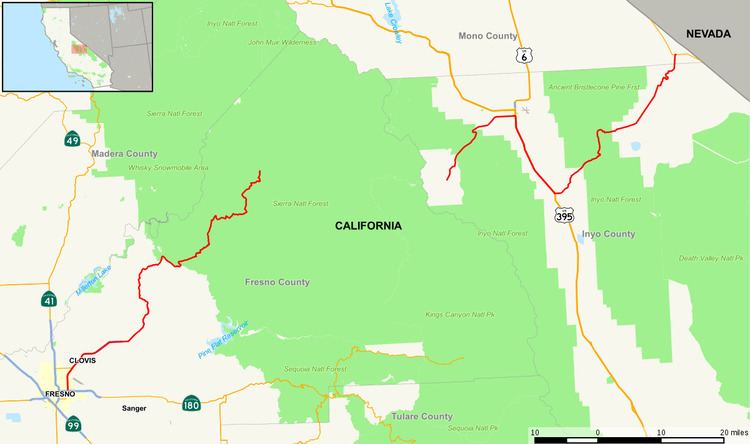 | ||
State Route 168 is a state highway in California, USA, which is separated into three distinct segments, in part by the Sierra Nevada mountains. This route is part of the California Freeway and Expressway System and is eligible for the State Scenic Highway System.
Contents
Map of CA-168, California, USA
Route description
The westernmost segment of SR 168 begins in southeast Fresno at the interchange with State Route 180, where it is known as the Sierra Freeway until it becomes Tollhouse Road near the northeast edge of Clovis. Tollhouse Road is a 4-lane expressway from the end of the freeway to Shepherd Avenue, east of which the highway is mostly an undivided 2-lane road. This segment continues east up into the Sierra Nevada, ending at Huntington Lake along the western slope of the range.
Before the reconstruction of urban Route 168 as a freeway, the route started at SR 41 and Shaw Avenue in Fresno. SR 168 ran along Shaw Avenue, Clovis Avenue, Third Street (Clovis), and Tollhouse Road to the current end of the freeway.
SR 168 cannot be used to cross the Sierra Nevada. The closest crossings of the Sierra Nevada are SR 120 via Tioga Pass to the north and Sherman Pass to the south. Both of these passes are accessible in warmer months only.
The middle segment of SR 168 has its western terminus at Lake Sabrina on the eastern slope of the Sierra Nevada. This rural mountain road runs east to US Highway 395 in Bishop.
The easternmost segment of SR 168 begins in Big Pine at US 395, and climbs into the White Mountains through Westgard Pass, passing the Ancient Bristlecone Pine Forest. From here it traverses Deep Springs Valley, home of Deep Springs College, before crossing into Fish Lake Valley, where the segment ends at State Route 266, just west of the Nevada Border.
History
Although conceived as a trans-Sierra highway connecting Fresno and Bishop the two segments were never connected. The rugged Sierra crest would have made construction very difficult and today two congressionally designated wilderness areas block the way.
Major intersections
Except where prefixed with a letter, postmiles were measured on the road as it was in 1964, based on the alignment that existed at the time, and do not necessarily reflect current mileage. R reflects a realignment in the route since then, M indicates a second realignment, L refers an overlap due to a correction or change, and T indicates postmiles classified as temporary (for a full list of prefixes, see the list of postmile definitions). Segments that remain unconstructed or have been relinquished to local control may be omitted. The numbers reset at county lines; the start and end postmiles in each county are given in the county column.