
Length 3.219 km | ||
 | ||
County | ||
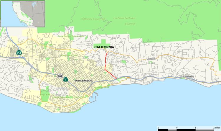
State Route 144 runs from Route 101 at Milpas Street in Santa Barbara, California to State Route 192 through the Sycamore Canyon.
Contents
Map of CA-144, Santa Barbara, CA, USA
Route description
Route 144 starts at Route 101's interchange with Milpas Street. The route heads northwest on Milpas, a conventional 4-lane thoroughfare. In less than four blocks, however, the route turns northeast on 'Mason Street, a two-lane residential street, passing by an elementary school and through a narrow bridge crossing the Sycamore Creek. Mason Street ends at Salinas Street; here, the route turns northwest onto Salinas Street, another two-lane street, until it reaches a traffic circle. From the circle, Route 144 continues north onto Sycamore Canyon Road, a winding two-lane road between steep hillsides to its terminus with Route 192/Stanwood Drive.
History
In 1999, the state law was changed to permit the relinquishment of Route 144 to the City of Santa Barbara. This was because the City of Santa Barbara wished to do several improvements on Milpas Street. One of these improvements includes the installation of a roundabout at the off-ramp from northbound Route 101, which Caltrans did not approve of. The roundabout controls traffic coming from Milpas Street, Carpinteria Street, and two ramps from and to Route 101. It is a significantly larger and bolder version of the Salinas Street roundabout, though the latter channels five streets. Currently, the portion from Route 101 to the Salinas traffic circle has been relinquished to the city but the portion on Sycamore Canyon remains as a state highway.
The final portion of Route 144 from Ranchito Vista Road to its junction with Route 192 had been closed off and on between 2005 and 2012 due to repetitive mudslides. In April 2012, crews completed repairs to the surrounding hillsides and reopened this segment of the highway.
Major intersections
Except where prefixed with a letter, postmiles were measured on the road as it was in 1964, based on the alignment that existed at the time, and do not necessarily reflect current mileage. R reflects a realignment in the route since then, M indicates a second realignment, L refers an overlap due to a correction or change, and T indicates postmiles classified as temporary (for a full list of prefixes, see the list of postmile definitions). Segments that remain unconstructed or have been relinquished to local control may be omitted. The entire route is in Santa Barbara, Santa Barbara County.