
Traversed by I-5 Road US Interstate 5 | Elevation 1,268 m Range Tehachapi Mountains | |
 | ||
Location Los Angeles and Kern counties, California Similar Fort Tejon, Frazier Mountain, San Emigdio Mountains, Mount Pinos, Newhall Pass | ||
Tejon pass ca
The Tejon Pass (pronounced "tay-HONE, tuh-HONE, or TAY-hone), previously known as Portezuelo de Cortes, Portezuela de Castac, and Fort Tejon Pass, is a mountain pass between the southwest end of the Tehachapi Mountains and northeastern San Emigdio Mountains, linking Southern California north to the Central Valley. It has been traversed by major roads such as the El Camino Viejo, the Stockton – Los Angeles Road, the Ridge Route, U.S. Route 99, and now Interstate 5.
Contents
- Tejon pass ca
- Map of Tejon Pass California 93243 USA
- GeographyEdit
- Pre ColumbianEdit
- 18th centuryEdit
- Old Tejon PassEdit
- Castaic PassEdit
- Fort Tejon PassEdit
- 20th centuryEdit
- Weather concernsEdit
- CommunitiesEdit
- References
Map of Tejon Pass, California 93243, USA
GeographyEdit
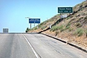
The highest point of the pass is near the northwestern-most corner of Los Angeles County, north of Gorman. Its highest point is 4,144 feet (1,263 m) or 4,160 feet (1,270 m) (the difference arises from the altitudes of Interstate 5, and both Peace Valley Road and Gorman Post Road that run next to the freeway at the pass' apex, respectively), 75 miles (121 km) northwest of downtown Los Angeles and 47 miles (76 km) south of Bakersfield.
The route of Interstate 5 winds through Tejon Pass (the highway's highest point in the state), connecting the southern part of the state with the San Joaquin Valley and the north.
The pass has a gradual rise from its southern approach of 1,362 feet (415 m) at Santa Clarita, but a precipitous descent through Grapevine Canyon toward the San Joaquin Valley on the north, where it ends at Grapevine at 1,499 feet (457 m).
On its northward slope lies Fort Tejon State Historic Park, the site of a former U.S. Army post, first garrisoned on August 10, 1854.
Pre-ColumbianEdit
Historians speak of the area around Gorman, California (just south of the crest of the Tejon Pass), as "one of the oldest continuously used roadside rest stops in California." This is because pre-Columbian indigenous Californians "would have stopped there when it was the Tataviam village of Kulshra'jek", a trading crossroads for hundreds to thousands of years.
18th centuryEdit
In 1772, Lieutenant Pedro Fages crossed the pass in pursuit of military deserters, and named it Portezuelo de Cortes (Cortes Pass). Fages also named the canyon beyond the pass leading down into the Tulare Basin, Cañada de las Uvas (Canyon of the Grapes) for all the grape vines growing in it.
In the late 18th century, El Camino Viejo, a road between Los Angeles and the Mission Santa Clara de Asis began to be used for travel north and south along the western San Joaquin Valley. It crossed over the pass and turned westward up Cuddy Canyon and then down San Emigdio Creek into the San Joaquin Valley.
Old Tejon PassEdit
In 1806, Father Jose Maria Zalvidea, diarist for the expedition of First Lieutenant Francisco Ruiz into the San Joaquin Valley, named the canyon, creek, and pass which had been discovered in 1776 by the explorer priest, Father Francisco Garces. He recorded the name as "Tejon" (badger)—after a dead badger found at the canyon's mouth. This original Tejon Pass (later called "Old Tejon Pass"), was situated 15 miles to the northeast of what is now Tejon Pass. The old pass went through the Tehachapi Mountains, at the top of the divide between Tejon Creek Canyon in the San Joaquin Valley and Cottonwood Creek Canyon in Antelope Valley.
Before 1854, the main route of travel into the San Joaquin Valley had come directly north from Elizabeth Lake (originally Laguna de Chico Lopez) across the Antelope Valley, over this original Tejon Pass, and down into Tejon Canyon, and then proceeded west along Tejon Creek—into the lands of the Rancho Tejon, that had been granted in 1843. This route to the pass diverted from the El Camino Viejo at Elisabeth Lake, and from 1849 to before 1854 it was the main road connecting the southern part of the state to the trail along the eastern side of the San Joaquin Valley to the goldfields to the north.
Castaic PassEdit
In 1843, Rancho Castac was established in La Cañada de las Uvas. During that same year, the first grant of Rancho Los Alamos y Agua Caliente included the pass, which was now called Portezuela de Castac (Castaic Pass).
Fort Tejon PassEdit
After the establishment of Fort Tejon and the Stockton - Los Angeles Road, the Portezuela de Castac began to be called the "Fort Tejon Pass." The rather poor wagon route of the old Tejon Pass route was generally abandoned, and eventually the Fort Tejon Pass took the shortened name it has today.
In 1858 the Butterfield Overland Mail stagecoach line ran through the pass on the Stockton - Los Angeles Road. The Butterfield Overland was discontinued in 1861 but was replaced by the Telegraph Stage Line, which stopped at almost all the former stations, including Gorman's, where the horses were changed. Six of them were used for the pull up from Bakersfield to Gorman's.
20th centuryEdit
The Ridge Route was the first automobile highway linking the Central Valley with the Los Angeles Basin. It was laid in a sinuous fashion through the ridges and gullies of the Sierra Pelona Mountains to the Tejon Pass around 1910. The northern portion of this highway, which became a part of U.S. Route 99, was known as "The Grapevine." The Ridge Route was replaced by a three-lane alternate highway in 1933, a four-lane expressway in 1947, and later by the eight-lane Interstate 5 Freeway in 1970.
Weather concernsEdit
The pass is sunny in the summer, spring, and fall, but is subject to severe weather and closure to traffic in the winter. The 40-mile stretch of Interstate 5 between Grapevine and Castaic is sometimes closed by the California Highway Patrol, generally because of the icy conditions combined with the steep grade of the pass, and the high traffic during the winter holidays. The Highway Patrol is also concerned, especially with the number of big-rigs that pass through, that one accident in the snowy conditions might force traffic to slow down or come to a complete stop, leaving hundreds of vehicles stalled at once. Whenever there is such a closure, traffic must either wait for it to reopen, or endure a multi-hour detour running between Bakersfield and Los Angeles via CA 58.
CommunitiesEdit
This historic gap has given its name to the Mountain Communities of the Tejon Pass. Beginning on the south at Santa Clarita, it passes through Castaic, Gorman, and Lebec, to end at Grapevine. It skirts the Tejon Ranch, where two large planned communities—Centennial and Tejon Mountain Village—are proposed.